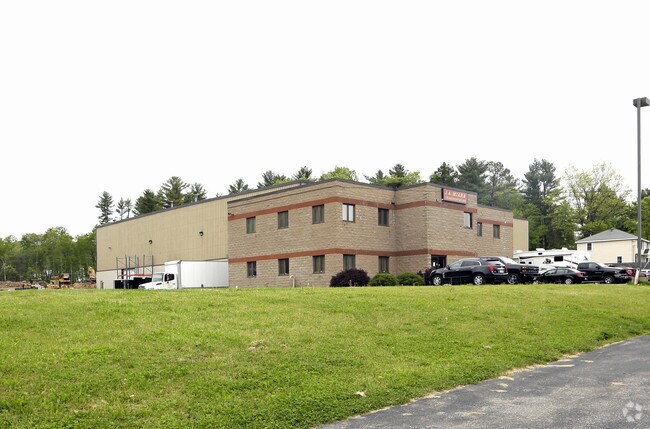
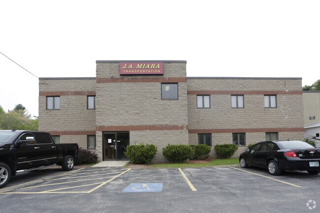
Property Record
12 Bockes Rd, Hudson, NH 03051

Save to a Folder
{{folder.Name}}
{{folder.ListingIds.length}} Properties
{{folder.ListingIds.length}} Property
Create a New Folder
Property Detail
12 Bockes Rd
Telephonefacility
Hillsborough
R2
New Hampshire
B and X Area of moderate flood hazard, usually the area between the limits of the 100-year and 500-year floods.
9.22 AC
2025
Hillsborough
2025
Boston
012102
Manchester-Nashua, NH
26,764 SF
HDSO-000136-000001
NEARBY LISTINGS FOR SALE OR LEASE
DEMOGRAPHICS near 12 Bockes Rd
1 mile
3 mile
5 mile
2025 Total Population
2,429
19,531
64,904
2030 Population
2,447
19,792
66,012
Pop Growth 2025-2030
+ 0.74%
+ 1.34%
+ 1.71%
Average Age
41
42
42
2025 Total Households
858
6,900
24,023
HH Growth 2025-2030
+ 0.70%
+ 1.30%
+ 1.70%
Median Household Inc
$145,070
$159,774
$135,140
Avg Household Size
2.80
2.80
2.70
2025 Avg HH Vehicles
2.00
3.00
2.00
Median Home Value
$484,047
$504,889
$498,885
Median Year Built
1989
1986
1983
Nearby Places
Map Layers
Map Styles
 Street
 Aerial
Layers
 Traffic
 Biking
Places
Listings with unknown addresses are not visible on the map
- Restaurants
- Banks
- Shops
- Fitness
- Groceries
PUBLIC TRANSPORTATION
AIRPORT
Manchester Boston Regional
Drive
Walk
Distance
Manchester Boston Regional
32 min
14.0 mi
Portsmouth International at Pease
Drive
Walk
Distance
Portsmouth International at Pease
72 min
46.9 mi
Freight Ports
Port of Boston
Drive
Walk
Distance
Port of Boston
64 min
44.2 mi
SALE & LEASE HISTORY
LISTING DATE
SALE/LEASE

Sep 14, 2018
For Lease
Jun 29, 2018
For Lease
Nearby Properties
Address
Land Use
TOTAL SIZE
Lot Size
Zoning
Address
Land Use
TOTAL SIZE
Lot Size
Zoning
195,778 SF
101.88 AC
RD
Address
Land Use
TOTAL SIZE
Lot Size
Zoning
58,339 SF
47.49 AC
RD
Address
Land Use
TOTAL SIZE
Lot Size
Zoning
142,524 SF
8.80 AC
ID
Address
Land Use
TOTAL SIZE
Lot Size
Zoning
119,547 SF
3.78 AC
B
Address
Land Use
TOTAL SIZE
Lot Size
Zoning
2,400 SF
15.50 AC
G1
Address
Land Use
TOTAL SIZE
Lot Size
Zoning
115,747 SF
9.99 AC
ID
Address
Land Use
TOTAL SIZE
Lot Size
Zoning
31,091 SF
3.42 AC
BD
Address
Land Use
TOTAL SIZE
Lot Size
Zoning
17,214 SF
18.60 AC
ID
Address
Land Use
TOTAL SIZE
Lot Size
Zoning
684 SF
178.86 AC
R2
Address
Land Use
TOTAL SIZE
Lot Size
Zoning
85,145 SF
6.10 AC
ID
Address
Land Use
TOTAL SIZE
Lot Size
Zoning
19,875 SF
4.56 AC
ID
Address
Land Use
TOTAL SIZE
Lot Size
Zoning
57,012 SF
6.76 AC
ID
Address
Land Use
TOTAL SIZE
Lot Size
Zoning
9,800 SF
10.09 AC
B
Address
Land Use
TOTAL SIZE
Lot Size
Zoning
1,352 SF
5.53 AC
BD
Address
Land Use
TOTAL SIZE
Lot Size
Zoning
24,225 SF
7 AC
AR-I
Address
Land Use
TOTAL SIZE
Lot Size
Zoning
48,675 SF
3.83 AC
ID
Address
Land Use
TOTAL SIZE
Lot Size
Zoning
78,595 SF
5.24 AC
ID
Address
Land Use
TOTAL SIZE
Lot Size
Zoning
3,095 SF
5.61 AC
NBD
Address
Land Use
TOTAL SIZE
Lot Size
Zoning
15,253 SF
5.09 AC
G1
Address
Land Use
TOTAL SIZE
Lot Size
Zoning
31,424 SF
7.03 AC
BD
Address
Land Use
TOTAL SIZE
Lot Size
Zoning
37,590 SF
3.94 AC
ID
Address
Land Use
TOTAL SIZE
Lot Size
Zoning
165.22 AC
G1
Address
Land Use
TOTAL SIZE
Lot Size
Zoning
25,140 SF
3.64 AC
ID
Address
Land Use
TOTAL SIZE
Lot Size
Zoning
36,068 SF
2.17 AC
ID
Address
Land Use
TOTAL SIZE
Lot Size
Zoning
22,500 SF
7.11 AC
G1
Address
Land Use
TOTAL SIZE
Lot Size
Zoning
2,480 SF
33.41 AC
ID
Address
Land Use
TOTAL SIZE
Lot Size
Zoning
31,370 SF
13.05 AC
ID
Address
Land Use
TOTAL SIZE
Lot Size
Zoning
3,000 SF
28.41 AC
G1
Address
Land Use
TOTAL SIZE
Lot Size
Zoning
6,100 SF
4.19 AC
I
The World's #1 Commercial Real Estate Marketplace
Connect with us
© 2026 CoStar Group
The information above has been obtained from sources believed reliable. While we do not doubt its accuracy we have not verified it and make no guarantee, warranty or representation about it. It is your responsibility to independently confirm its accuracy and completeness. Any projections, opinions, assumptions, or estimates used are for example only and do not represent the current or future performance of the property. The value of this transaction to you depends on tax and other factors which should be evaluated by your tax, financial, and legal advisors. You and your advisors should conduct a careful, independent investigation of the property to determine to your satisfaction the suitability of the property for your needs.