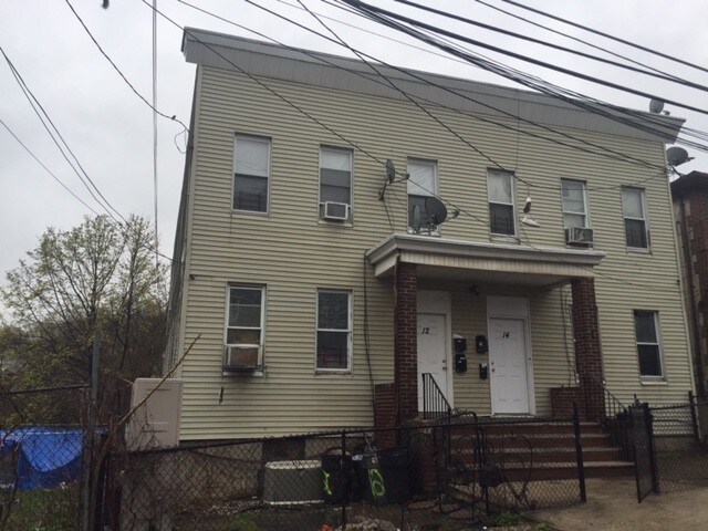
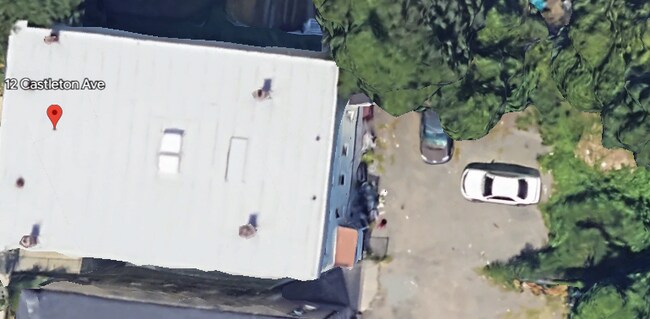
Property Record
12 Castleton Ave, Staten Island, NY 10301


Property Detail
12 Castleton Ave
00109-0032
Richmond
Multifamilydwelling
New York
R3A
32
B and X Area of moderate flood hazard, usually the area between the limits of the 100-year and 500-year floods.
0.16 AC
2024
Tompkinsville
2025
Long Island (New York)
007500
New York-Jersey City-White Plains, NY-NJ
4,440 SF
NEARBY LISTINGS FOR SALE OR LEASE
DEMOGRAPHICS near 12 Castleton Ave
1 mile
3 mile
5 mile
2025 Total Population
44,953
258,267
764,622
2030 Population
45,590
263,207
759,412
Pop Growth 2025-2030
+ 1.42%
+ 1.91%
(0.68%)
Average Age
40
41
40
2025 Total Households
16,229
94,627
261,319
HH Growth 2025-2030
+ 1.53%
+ 2.00%
(0.56%)
Median Household Inc
$64,816
$82,552
$77,994
Avg Household Size
2.50
2.60
2.80
2025 Avg HH Vehicles
1.00
1.00
1.00
Median Home Value
$706,392
$700,683
$735,130
Median Year Built
1954
1957
1953
Nearby Places
Map Layers
Map Styles
 Street
 Aerial
Transit
 Traffic
 Biking
Places
Listings with unknown addresses are not visible on the map
- Restaurants
- Banks
- Shops
- Fitness
- Groceries
PUBLIC TRANSPORTATION
TRANSIT/SUBWAY
Tompkinsville (Staten Island Railway - New York MTA Subway (The Subway))
Drive
Walk
Distance
Tompkinsville (Staten Island Railway - New York MTA Subway (The Subway))
3 min
13 min
0.7 mi
Stapleton (Staten Island Railway - New York MTA Subway (The Subway))
Drive
Walk
Distance
Stapleton (Staten Island Railway - New York MTA Subway (The Subway))
4 min
20 min
1.0 mi
St George (Staten Island Railway - New York MTA Subway (The Subway))
Drive
Walk
Distance
St George (Staten Island Railway - New York MTA Subway (The Subway))
5 min
20 min
1.0 mi
COMMUTER RAIL
Tompkinsville (Staten Island Railway - New York MTA Subway (The Subway))
Drive
Walk
Distance
Tompkinsville (Staten Island Railway - New York MTA Subway (The Subway))
3 min
13 min
0.7 mi
Stapleton (Staten Island Railway - New York MTA Subway (The Subway))
Drive
Walk
Distance
Stapleton (Staten Island Railway - New York MTA Subway (The Subway))
4 min
20 min
1.0 mi
AIRPORT
Newark Liberty International
Drive
Walk
Distance
Newark Liberty International
26 min
14.3 mi
LaGuardia
Drive
Walk
Distance
LaGuardia
42 min
22.6 mi
John F Kennedy International
Drive
Walk
Distance
John F Kennedy International
45 min
25.1 mi
Freight Ports
New York Container Terminal
Drive
Walk
Distance
New York Container Terminal
15 min
7.2 mi
SALE & LEASE HISTORY
LISTING DATE
SALE/LEASE

Sep 28, 2023
For Lease
Oct 05, 2022
For Sale
Jan 02, 2018
For Sale
Nearby Properties
Address
Land Use
TOTAL SIZE
Lot Size
Zoning
Address
Land Use
TOTAL SIZE
Lot Size
Zoning
Address
Land Use
TOTAL SIZE
Lot Size
Zoning
22.49 AC
HC
Address
Land Use
TOTAL SIZE
Lot Size
Zoning
1.01 AC
Address
Land Use
TOTAL SIZE
Lot Size
Zoning
30.92 AC
Address
Land Use
TOTAL SIZE
Lot Size
Zoning
3.27 AC
Address
Land Use
TOTAL SIZE
Lot Size
Zoning
17.60 AC
Address
Land Use
TOTAL SIZE
Lot Size
Zoning
28.47 AC
I-H
Address
Land Use
TOTAL SIZE
Lot Size
Zoning
114.66 AC
BMHO
Address
Land Use
TOTAL SIZE
Lot Size
Zoning
115.33 AC
IH
Address
Land Use
TOTAL SIZE
Lot Size
Zoning
74.35 AC
TDD
Address
Land Use
TOTAL SIZE
Lot Size
Zoning
Address
Land Use
TOTAL SIZE
Lot Size
Zoning
1,502 SF
0.69 AC
C-1
Address
Land Use
TOTAL SIZE
Lot Size
Zoning
Address
Land Use
TOTAL SIZE
Lot Size
Zoning
236,591 SF
207.66 AC
R3-2
Address
Land Use
TOTAL SIZE
Lot Size
Zoning
73.85 AC
IH
Address
Land Use
TOTAL SIZE
Lot Size
Zoning
5.77 AC
BMHO
Address
Land Use
TOTAL SIZE
Lot Size
Zoning
2.77 AC
Address
Land Use
TOTAL SIZE
Lot Size
Zoning
538,240 SF
12.08 AC
R2
Address
Land Use
TOTAL SIZE
Lot Size
Zoning
25.67 AC
Address
Land Use
TOTAL SIZE
Lot Size
Zoning
286,000 SF
12.63 AC
PARK
Address
Land Use
TOTAL SIZE
Lot Size
Zoning
521,405 SF
52.79 AC
R3-1
Address
Land Use
TOTAL SIZE
Lot Size
Zoning
816 SF
1.57 AC
Address
Land Use
TOTAL SIZE
Lot Size
Zoning
Address
Land Use
TOTAL SIZE
Lot Size
Zoning
111,000 SF
186.03 AC
PARK
Address
Land Use
TOTAL SIZE
Lot Size
Zoning
Address
Land Use
TOTAL SIZE
Lot Size
Zoning
48.68 AC
IH
Address
Land Use
TOTAL SIZE
Lot Size
Zoning
Address
Land Use
TOTAL SIZE
Lot Size
Zoning
Address
Land Use
TOTAL SIZE
Lot Size
Zoning
Address
Land Use
TOTAL SIZE
Lot Size
Zoning
The World's #1 Commercial Real Estate Marketplace
Connect with us
© 2026 CoStar Group
The information above has been obtained from sources believed reliable. While we do not doubt its accuracy we have not verified it and make no guarantee, warranty or representation about it. It is your responsibility to independently confirm its accuracy and completeness. Any projections, opinions, assumptions, or estimates used are for example only and do not represent the current or future performance of the property. The value of this transaction to you depends on tax and other factors which should be evaluated by your tax, financial, and legal advisors. You and your advisors should conduct a careful, independent investigation of the property to determine to your satisfaction the suitability of the property for your needs.