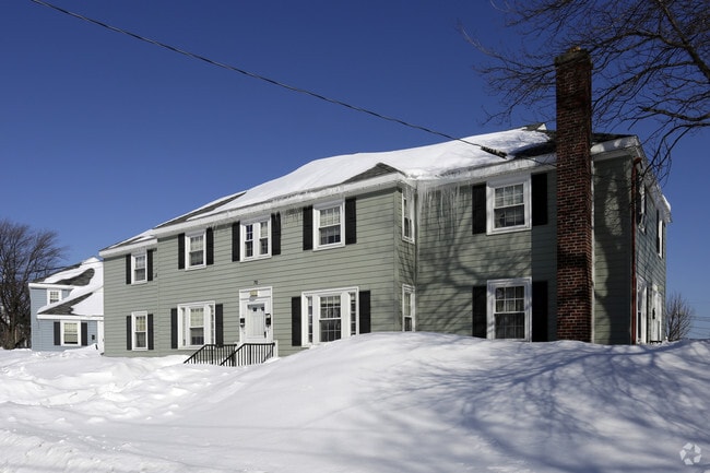
Property Record
12 Doane St, Quincy, MA 02169
NEARBY LISTINGS FOR SALE OR LEASE
Property Detail
12 Doane St
Governmentalpublicusegeneral
Norfolk
AE
Massachusetts
25021C0089F
3.23 AC
0
Germantown
2025
Boston
417703
Boston-Cambridge-Newton, MA-NH
5,322 SF
QUIN-001098I-000000-000001
DEMOGRAPHICS near 12 Doane St
1 Mile
3 Mile
5 Mile
2024 Total Population
10,626
95,582
206,273
2029 Population
10,458
95,167
205,369
Pop Growth 2024-2029
(1.58%)
(0.43%)
(0.44%)
Average Age
42
42
42
2024 Total Households
4,507
41,598
87,042
HH Growth 2024-2029
(1.82%)
(0.37%)
(0.41%)
Median Household Inc
$73,961
$89,984
$97,813
Avg Household Size
2.30
2.20
2.30
2024 Avg HH Vehicles
2.00
1.00
2.00
Median Home Value
$483,948
$545,766
$610,896
Median Year Built
1952
1958
1958
Nearby Places
Map Layers
Map Styles
 Street
 Aerial
- Restaurants
- Banks
- Shops
- Fitness
- Groceries
PUBLIC TRANSPORTATION
COMMUTER RAIL
Quincy Center Station (Greenbush Line - Massachusetts Bay Transportation Authority Commuter Rail (Purple Line), Kingston/Plymouth Line - Massachusetts Bay Transportation Authority Commuter Rail (Purple Line), Middleborough/Lakeville Line - Massachusetts Bay Transportation Authority Commuter Rail (Purple Line), Red Line - Massachusetts Bay Transportation Authority Commuter Rail (Purple Line))
DRIVE
WALK
Distance
Quincy Center Station (Greenbush Line - Massachusetts Bay Transportation Authority Commuter Rail (Purple Line), Kingston/Plymouth Line - Massachusetts Bay Transportation Authority Commuter Rail (Purple Line), Middleborough/Lakeville Line - Massachusetts Bay Transportation Authority Commuter Rail (Purple Line), Red Line - Massachusetts Bay Transportation Authority Commuter Rail (Purple Line))
7 min
3.2 mi
Weymouth Landing/East Braintree (Greenbush Line - MBTA)
DRIVE
WALK
Distance
Weymouth Landing/East Braintree (Greenbush Line - MBTA)
13 min
5.8 mi
AIRPORT
General Edward Lawrence Logan International
DRIVE
WALK
Distance
General Edward Lawrence Logan International
27 min
13.8 mi
Freight Ports
Port of Boston
DRIVE
WALK
Distance
Port of Boston
24 min
11.6 mi
Nearby Properties
Address
Land Use
TOTAL SIZE
Lot Size
Zoning
Address
Land Use
TOTAL SIZE
Lot Size
Zoning
148,456 SF
0.43 AC
Address
Land Use
TOTAL SIZE
Lot Size
Zoning
3.31 AC
BUSC
Address
Land Use
TOTAL SIZE
Lot Size
Zoning
236,154 SF
1.41 AC
BUSC
Address
Land Use
TOTAL SIZE
Lot Size
Zoning
14.81 AC
Address
Land Use
TOTAL SIZE
Lot Size
Zoning
9.10 AC
RESC
Address
Land Use
TOTAL SIZE
Lot Size
Zoning
202,858 SF
2.30 AC
Address
Land Use
TOTAL SIZE
Lot Size
Zoning
5.06 AC
BUSC
Address
Land Use
TOTAL SIZE
Lot Size
Zoning
233,488 SF
9.82 AC
Address
Land Use
TOTAL SIZE
Lot Size
Zoning
132,997 SF
1.45 AC
Address
Land Use
TOTAL SIZE
Lot Size
Zoning
147,611 SF
0.62 AC
BUSC
Address
Land Use
TOTAL SIZE
Lot Size
Zoning
11.90 AC
PUD
Address
Land Use
TOTAL SIZE
Lot Size
Zoning
229,928 SF
3.79 AC
Address
Land Use
TOTAL SIZE
Lot Size
Zoning
133,254 SF
4.21 AC
Address
Land Use
TOTAL SIZE
Lot Size
Zoning
124,274 SF
0.62 AC
Address
Land Use
TOTAL SIZE
Lot Size
Zoning
10.38 AC
Address
Land Use
TOTAL SIZE
Lot Size
Zoning
233,530 SF
6.70 AC
PUD
Address
Land Use
TOTAL SIZE
Lot Size
Zoning
24,156 SF
7.65 AC
RESB
Address
Land Use
TOTAL SIZE
Lot Size
Zoning
134,342 SF
1.03 AC
BUSC
Address
Land Use
TOTAL SIZE
Lot Size
Zoning
617,116 SF
79.59 AC
INDB
Address
Land Use
TOTAL SIZE
Lot Size
Zoning
204,944 SF
3.83 AC
Address
Land Use
TOTAL SIZE
Lot Size
Zoning
9.94 AC
Address
Land Use
TOTAL SIZE
Lot Size
Zoning
3,375 SF
12.03 AC
PUD
Address
Land Use
TOTAL SIZE
Lot Size
Zoning
10.04 AC
PUD
Address
Land Use
TOTAL SIZE
Lot Size
Zoning
244,796 SF
2.42 AC
Address
Land Use
TOTAL SIZE
Lot Size
Zoning
11.39 AC
100
Address
Land Use
TOTAL SIZE
Lot Size
Zoning
111,871 SF
4.72 AC
RESC
Address
Land Use
TOTAL SIZE
Lot Size
Zoning
122,808 SF
3.41 AC
Address
Land Use
TOTAL SIZE
Lot Size
Zoning
1.36 AC
BUSC
Address
Land Use
TOTAL SIZE
Lot Size
Zoning
122,160 SF
6.61 AC
PUD
Address
Land Use
TOTAL SIZE
Lot Size
Zoning
5.03 AC
The World's #1 Commercial Real Estate Marketplace
Connect with us
© 2025 CoStar Group
The information above has been obtained from sources believed reliable. While we do not doubt its accuracy we have not verified it and make no guarantee, warranty or representation about it. It is your responsibility to independently confirm its accuracy and completeness. Any projections, opinions, assumptions, or estimates used are for example only and do not represent the current or future performance of the property. The value of this transaction to you depends on tax and other factors which should be evaluated by your tax, financial, and legal advisors. You and your advisors should conduct a careful, independent investigation of the property to determine to your satisfaction the suitability of the property for your needs.