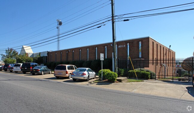
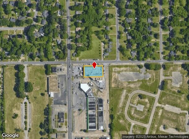
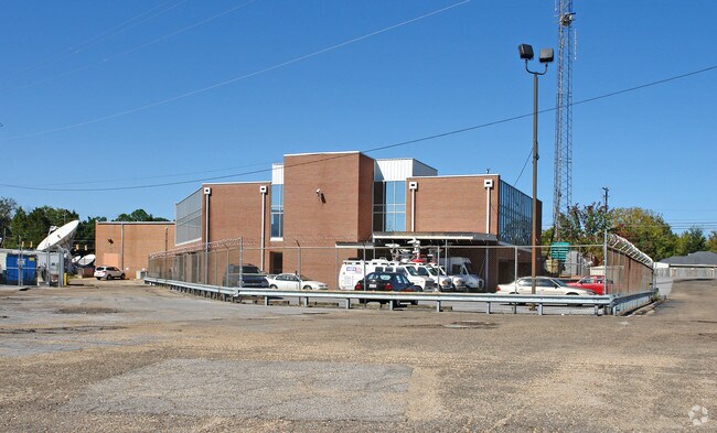
Property Record
12 E Delano Ave, Montgomery, AL 36105
NEARBY LISTINGS FOR SALE OR LEASE
Property Detail
12 E Delano Ave
Montgomery, AL
Cloverland Section 2 Replat
10-09-30-3-004-001.000
REPLAT OF PART OF BLK I 1009303004001000
Religious
Montgomery
X
Alabama
01101C0208J
a2
0
0.53 AC
2025
South Montgomery
002201
Montgomery
33,462 SF
DEMOGRAPHICS near 12 E Delano Ave
1 Mile
3 Mile
5 Mile
2024 Total Population
10,270
53,557
110,539
2029 Population
10,307
53,568
109,338
Pop Growth 2024-2029
+ 0.36%
+ 0.02%
(1.09%)
Average Age
41
39
38
2024 Total Households
4,262
21,815
45,021
HH Growth 2024-2029
+ 0.31%
+ 0.29%
(1.00%)
Median Household Inc
$32,639
$34,742
$36,102
Avg Household Size
2.30
2.20
2.30
2024 Avg HH Vehicles
2.00
2.00
2.00
Median Home Value
$68,004
$97,834
$106,801
Median Year Built
1957
1962
1969
Nearby Places
Map Layers
Map Styles
 Street
 Aerial
- Restaurants
- Banks
- Shops
- Fitness
- Groceries
PUBLIC TRANSPORTATION
AIRPORT
Montgomery Regional (Dannelly Field)
DRIVE
WALK
Distance
Montgomery Regional (Dannelly Field)
10 min
7.1 mi
Freight Ports
Port of Mobile
DRIVE
WALK
Distance
Port of Mobile
180 min
166.2 mi
Nearby Properties
Address
Land Use
TOTAL SIZE
Lot Size
Zoning
Address
Land Use
TOTAL SIZE
Lot Size
Zoning
800,140 SF
2.27 AC
T5
Address
Land Use
TOTAL SIZE
Lot Size
Zoning
392,741 SF
2.98 AC
T5
Address
Land Use
TOTAL SIZE
Lot Size
Zoning
150,842 SF
5.40 AC
T5
Address
Land Use
TOTAL SIZE
Lot Size
Zoning
260,402 SF
17 AC
O-2
Address
Land Use
TOTAL SIZE
Lot Size
Zoning
193,643 SF
1.61 AC
T5
Address
Land Use
TOTAL SIZE
Lot Size
Zoning
36,543 SF
0.62 AC
SD-M
Address
Land Use
TOTAL SIZE
Lot Size
Zoning
40,829 SF
50.49 AC
SD
Address
Land Use
TOTAL SIZE
Lot Size
Zoning
10,844 SF
1.63 AC
Address
Land Use
TOTAL SIZE
Lot Size
Zoning
285,162 SF
M-1
Address
Land Use
TOTAL SIZE
Lot Size
Zoning
107,355 SF
4.12 AC
T5
Address
Land Use
TOTAL SIZE
Lot Size
Zoning
93,981 SF
1.90 AC
T5
Address
Land Use
TOTAL SIZE
Lot Size
Zoning
13,273 SF
2.05 AC
T5
Address
Land Use
TOTAL SIZE
Lot Size
Zoning
32,902 SF
14 AC
R-75-M
Address
Land Use
TOTAL SIZE
Lot Size
Zoning
8,519 SF
15.60 AC
B-2
Address
Land Use
TOTAL SIZE
Lot Size
Zoning
58,930 SF
2.24 AC
T5
Address
Land Use
TOTAL SIZE
Lot Size
Zoning
91,378 SF
2.46 AC
SD-M
Address
Land Use
TOTAL SIZE
Lot Size
Zoning
117,175 SF
1.49 AC
T5
Address
Land Use
TOTAL SIZE
Lot Size
Zoning
113,449 SF
0.80 AC
T5
Address
Land Use
TOTAL SIZE
Lot Size
Zoning
77,905 SF
0.83 AC
T5
Address
Land Use
TOTAL SIZE
Lot Size
Zoning
341,170 SF
O-2
Address
Land Use
TOTAL SIZE
Lot Size
Zoning
38,226 SF
5.77 AC
T5
Address
Land Use
TOTAL SIZE
Lot Size
Zoning
120,509 SF
0.29 AC
T5
Address
Land Use
TOTAL SIZE
Lot Size
Zoning
1.72 AC
T5
Address
Land Use
TOTAL SIZE
Lot Size
Zoning
14,733 SF
19 AC
O-2
Address
Land Use
TOTAL SIZE
Lot Size
Zoning
249,231 SF
20 AC
INST
Address
Land Use
TOTAL SIZE
Lot Size
Zoning
135,573 SF
35 AC
O-2
Address
Land Use
TOTAL SIZE
Lot Size
Zoning
116,707 SF
0.28 AC
T5
Address
Land Use
TOTAL SIZE
Lot Size
Zoning
81,736 SF
0.63 AC
T5
Address
Land Use
TOTAL SIZE
Lot Size
Zoning
3,401 SF
3.21 AC
T5
Address
Land Use
TOTAL SIZE
Lot Size
Zoning
128,328 SF
2.27 AC
T5
The World's #1 Commercial Real Estate Marketplace
Connect with us
© 2025 CoStar Group
The information above has been obtained from sources believed reliable. While we do not doubt its accuracy we have not verified it and make no guarantee, warranty or representation about it. It is your responsibility to independently confirm its accuracy and completeness. Any projections, opinions, assumptions, or estimates used are for example only and do not represent the current or future performance of the property. The value of this transaction to you depends on tax and other factors which should be evaluated by your tax, financial, and legal advisors. You and your advisors should conduct a careful, independent investigation of the property to determine to your satisfaction the suitability of the property for your needs.