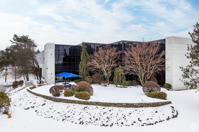
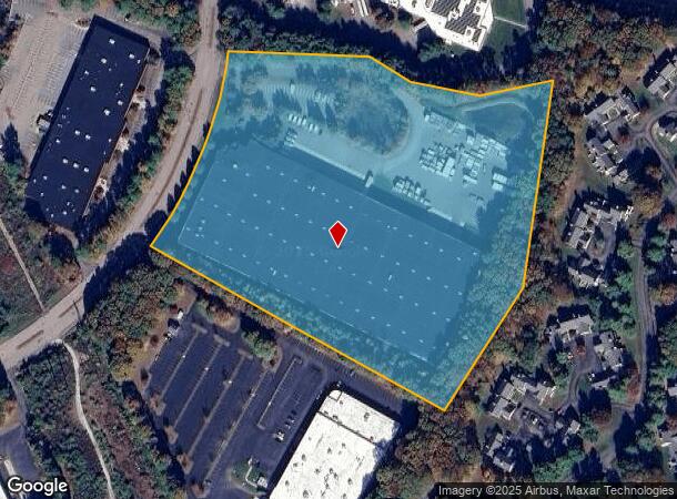
Property Record
12 Forge Pky, Franklin, MA 02038

Current Lease Availabilities
NEARBY LISTINGS FOR SALE OR LEASE
Property Detail
12 Forge Pky
FRAN-000275-000000-000003
Norfolk
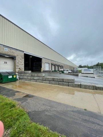
Warehouse
Massachusetts
X
3
25021C0308F
14.60 AC
2025
I-95 Corridor South
2025
Boston
442105
Boston-Cambridge-Newton, MA-NH
241,740 SF
DEMOGRAPHICS near 12 Forge Pky
1 Mile
3 Mile
5 Mile
2024 Total Population
2,603
33,814
69,698
2029 Population
2,551
33,644
69,346
Pop Growth 2024-2029
(2.00%)
(0.50%)
(0.51%)
Average Age
42
41
41
2024 Total Households
1,058
12,670
25,336
HH Growth 2024-2029
(2.08%)
(0.53%)
(0.56%)
Median Household Inc
$145,201
$123,989
$131,656
Avg Household Size
2.40
2.60
2.70
2024 Avg HH Vehicles
2.00
2.00
2.00
Median Home Value
$466,019
$474,788
$487,801
Median Year Built
1984
1982
1981
Nearby Places
Map Layers
Map Styles
 Street
 Aerial
- Restaurants
- Banks
- Shops
- Fitness
- Groceries
PUBLIC TRANSPORTATION
COMMUTER RAIL
Forge Park/Route 495 (Franklin Line - Massachusetts Bay Transportation Authority Commuter Rail (Purple Line))
DRIVE
WALK
Distance
Forge Park/Route 495 (Franklin Line - Massachusetts Bay Transportation Authority Commuter Rail (Purple Line))
3 min
18 min
1.0 mi
Franklin (Franklin Line - Massachusetts Bay Transportation Authority Commuter Rail (Purple Line))
DRIVE
WALK
Distance
Franklin (Franklin Line - Massachusetts Bay Transportation Authority Commuter Rail (Purple Line))
6 min
2.8 mi
AIRPORT
Rhode Island Tf Green International
DRIVE
WALK
Distance
Rhode Island Tf Green International
48 min
30.6 mi
Worcester Regional
DRIVE
WALK
Distance
Worcester Regional
52 min
35.0 mi
General Edward Lawrence Logan International
DRIVE
WALK
Distance
General Edward Lawrence Logan International
61 min
43.1 mi
Freight Ports
Port of Boston
DRIVE
WALK
Distance
Port of Boston
58 min
37.7 mi
Nearby Properties
Address
Land Use
TOTAL SIZE
Lot Size
Zoning
Address
Land Use
TOTAL SIZE
Lot Size
Zoning
85.04 AC
Address
Land Use
TOTAL SIZE
Lot Size
Zoning
20.97 AC
CRPC
Address
Land Use
TOTAL SIZE
Lot Size
Zoning
322,615 SF
17.33 AC
SUBN
Address
Land Use
TOTAL SIZE
Lot Size
Zoning
14.82 AC
AGR
Address
Land Use
TOTAL SIZE
Lot Size
Zoning
23.38 AC
Address
Land Use
TOTAL SIZE
Lot Size
Zoning
Address
Land Use
TOTAL SIZE
Lot Size
Zoning
39.30 AC
Address
Land Use
TOTAL SIZE
Lot Size
Zoning
31.57 AC
Address
Land Use
TOTAL SIZE
Lot Size
Zoning
279,174 SF
59.96 AC
Address
Land Use
TOTAL SIZE
Lot Size
Zoning
0.58 AC
Address
Land Use
TOTAL SIZE
Lot Size
Zoning
345,000 SF
60.44 AC
BUS1
Address
Land Use
TOTAL SIZE
Lot Size
Zoning
183,839 SF
39.29 AC
IND
Address
Land Use
TOTAL SIZE
Lot Size
Zoning
300,000 SF
64.63 AC
IND
Address
Land Use
TOTAL SIZE
Lot Size
Zoning
148,387 SF
47.03 AC
Address
Land Use
TOTAL SIZE
Lot Size
Zoning
253,656 SF
44.84 AC
IND
Address
Land Use
TOTAL SIZE
Lot Size
Zoning
238,602 SF
109.37 AC
Address
Land Use
TOTAL SIZE
Lot Size
Zoning
238,975 SF
33.82 AC
IND
Address
Land Use
TOTAL SIZE
Lot Size
Zoning
4.14 AC
Address
Land Use
TOTAL SIZE
Lot Size
Zoning
451,000 SF
90.70 AC
IND
Address
Land Use
TOTAL SIZE
Lot Size
Zoning
151,021 SF
14.56 AC
Address
Land Use
TOTAL SIZE
Lot Size
Zoning
208,826 SF
18.96 AC
IND
Address
Land Use
TOTAL SIZE
Lot Size
Zoning
300,000 SF
37.97 AC
Address
Land Use
TOTAL SIZE
Lot Size
Zoning
16.99 AC
Address
Land Use
TOTAL SIZE
Lot Size
Zoning
232,152 SF
17.07 AC
Address
Land Use
TOTAL SIZE
Lot Size
Zoning
39.40 AC
Address
Land Use
TOTAL SIZE
Lot Size
Zoning
203,792 SF
27.93 AC
IND
Address
Land Use
TOTAL SIZE
Lot Size
Zoning
152,752 SF
10.21 AC
Address
Land Use
TOTAL SIZE
Lot Size
Zoning
120,327 SF
28.75 AC
BUS2
Address
Land Use
TOTAL SIZE
Lot Size
Zoning
209,282 SF
15.61 AC
The World's #1 Commercial Real Estate Marketplace
Connect with us
© 2025 CoStar Group
The information above has been obtained from sources believed reliable. While we do not doubt its accuracy we have not verified it and make no guarantee, warranty or representation about it. It is your responsibility to independently confirm its accuracy and completeness. Any projections, opinions, assumptions, or estimates used are for example only and do not represent the current or future performance of the property. The value of this transaction to you depends on tax and other factors which should be evaluated by your tax, financial, and legal advisors. You and your advisors should conduct a careful, independent investigation of the property to determine to your satisfaction the suitability of the property for your needs.