Property Record
12 Frye Mill Rd, Wilton, NH 03086


NEARBY LISTINGS FOR SALE OR LEASE
-
-
View all Wilton listings for sale on LoopNet.com
Property Detail
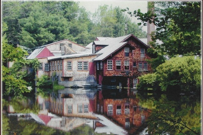
12 Frye Mill Rd
WLTN-000000-A000023
Hillsborough
Industrialgeneral
New Hampshire
X
23
33011C0431D
2.40 AC
2024
Hillsborough
2024
Boston
019000
Manchester-Nashua, NH
DEMOGRAPHICS near 12 Frye Mill Rd
1 Mile
3 Mile
5 Mile
2024 Total Population
246
3,431
7,815
2029 Population
250
3,438
7,884
Pop Growth 2024-2029
+ 1.63%
+ 0.20%
+ 0.88%
Average Age
44
44
43
2024 Total Households
95
1,367
3,054
HH Growth 2024-2029
+ 1.05%
+ 0.07%
+ 0.79%
Median Household Inc
$111,956
$100,309
$105,550
Avg Household Size
2.60
2.50
2.50
2024 Avg HH Vehicles
3.00
2.00
2.00
Median Home Value
$409,677
$371,402
$374,399
Median Year Built
1985
1971
1979
Nearby Places
Map Layers
Map Styles
 Street
 Aerial
- Restaurants
- Banks
- Shops
- Fitness
- Groceries
PUBLIC TRANSPORTATION
AIRPORT
Manchester Boston Regional
DRIVE
WALK
Distance
Manchester Boston Regional
52 min
26.7 mi
Freight Ports
Port of Boston
DRIVE
WALK
Distance
Port of Boston
104 min
67.6 mi
Nearby Properties
Address
Land Use
TOTAL SIZE
Lot Size
Zoning
Address
Land Use
TOTAL SIZE
Lot Size
Zoning
87,438 SF
55.60 AC
SZ
Address
Land Use
TOTAL SIZE
Lot Size
Zoning
127,722 SF
23.87 AC
I
Address
Land Use
TOTAL SIZE
Lot Size
Zoning
37,157 SF
1.60 AC
RA
Address
Land Use
TOTAL SIZE
Lot Size
Zoning
112,299 SF
3.50 AC
I
Address
Land Use
TOTAL SIZE
Lot Size
Zoning
10.10 AC
I
Address
Land Use
TOTAL SIZE
Lot Size
Zoning
29,404 SF
1.40 AC
I
Address
Land Use
TOTAL SIZE
Lot Size
Zoning
15,426 SF
6.40 AC
RA
Address
Land Use
TOTAL SIZE
Lot Size
Zoning
75.38 AC
RA R
Address
Land Use
TOTAL SIZE
Lot Size
Zoning
6.50 AC
I
Address
Land Use
TOTAL SIZE
Lot Size
Zoning
23.50 AC
RA R
Address
Land Use
TOTAL SIZE
Lot Size
Zoning
4,702 SF
136.50 AC
RA
Address
Land Use
TOTAL SIZE
Lot Size
Zoning
Address
Land Use
TOTAL SIZE
Lot Size
Zoning
6,000 SF
5.10 AC
I
Address
Land Use
TOTAL SIZE
Lot Size
Zoning
20.30 AC
RA
Address
Land Use
TOTAL SIZE
Lot Size
Zoning
13,916 SF
8.20 AC
VILLAG
Address
Land Use
TOTAL SIZE
Lot Size
Zoning
6.33 AC
I
Address
Land Use
TOTAL SIZE
Lot Size
Zoning
15,702 SF
0.90 AC
SZ
Address
Land Use
TOTAL SIZE
Lot Size
Zoning
9,213 SF
18.76 AC
RA R
Address
Land Use
TOTAL SIZE
Lot Size
Zoning
Address
Land Use
TOTAL SIZE
Lot Size
Zoning
9,266 SF
0.88 AC
RD
Address
Land Use
TOTAL SIZE
Lot Size
Zoning
44,774 SF
1.33 AC
I
Address
Land Use
TOTAL SIZE
Lot Size
Zoning
2.10 AC
RD
Address
Land Use
TOTAL SIZE
Lot Size
Zoning
10,364 SF
0.30 AC
RD
Address
Land Use
TOTAL SIZE
Lot Size
Zoning
46,146 SF
2.30 AC
I
Address
Land Use
TOTAL SIZE
Lot Size
Zoning
8,520 SF
0.80 AC
RD
Address
Land Use
TOTAL SIZE
Lot Size
Zoning
2.41 AC
C
Address
Land Use
TOTAL SIZE
Lot Size
Zoning
4,192 SF
3 AC
C
Address
Land Use
TOTAL SIZE
Lot Size
Zoning
25 AC
RA R
Address
Land Use
TOTAL SIZE
Lot Size
Zoning
7,175 SF
0.40 AC
RD
Address
Land Use
TOTAL SIZE
Lot Size
Zoning
37,424 SF
6.15 AC
I
The World's #1 Commercial Real Estate Marketplace
Connect with us
© 2025 CoStar Group
The information above has been obtained from sources believed reliable. While we do not doubt its accuracy we have not verified it and make no guarantee, warranty or representation about it. It is your responsibility to independently confirm its accuracy and completeness. Any projections, opinions, assumptions, or estimates used are for example only and do not represent the current or future performance of the property. The value of this transaction to you depends on tax and other factors which should be evaluated by your tax, financial, and legal advisors. You and your advisors should conduct a careful, independent investigation of the property to determine to your satisfaction the suitability of the property for your needs.