Property Record
12 Main St, Pelham, NH 03076

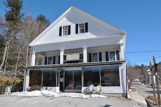
Property Detail
12 Main St
PLHM-000022-000000-000007-000255
HILLSBOROUGH
Religious
New Hampshire
MUZD
4.44 AC
B and X Area of moderate flood hazard, usually the area between the limits of the 100-year and 500-year floods.
Hillsborough
2025
Boston
2025
Manchester-Nashua, NH
002701
NEARBY LISTINGS FOR SALE OR LEASE
-
-
View all Pelham listings for sale on LoopNet.com
DEMOGRAPHICS near 12 Main St
1 mile
3 mile
5 mile
2025 Total Population
972
6,859
17,416
2030 Population
977
6,956
17,684
Pop Growth 2025-2030
+ 0.51%
+ 1.41%
+ 1.54%
Average Age
40
40
42
2025 Total Households
318
2,273
6,127
HH Growth 2025-2030
+ 0.63%
+ 1.41%
+ 1.53%
Median Household Inc
$163,666
$165,230
$148,412
Avg Household Size
3.10
3.00
2.80
2025 Avg HH Vehicles
3.00
3.00
2.00
Median Home Value
$559,122
$597,778
$568,246
Median Year Built
1988
1987
1983
Nearby Places
Map Layers
Map Styles
 Street
 Aerial
Layers
 Traffic
 Biking
Places
Listings with unknown addresses are not visible on the map
- Restaurants
- Banks
- Shops
- Fitness
- Groceries
PUBLIC TRANSPORTATION
COMMUTER RAIL
Lowell (Lowell Line - Massachusetts Bay Transportation Authority Commuter Rail (Purple Line))
Drive
Walk
Distance
Lowell (Lowell Line - Massachusetts Bay Transportation Authority Commuter Rail (Purple Line))
17 min
7.5 mi
AIRPORT
Manchester Boston Regional
Drive
Walk
Distance
Manchester Boston Regional
41 min
23.0 mi
Freight Ports
Port of Boston
Drive
Walk
Distance
Port of Boston
56 min
37.2 mi
SALE & LEASE HISTORY
LISTING DATE
SALE/LEASE

Sep 01, 2017
For Sale
Mar 25, 2019
For Sale
Jul 06, 2022
For Sale
Nearby Properties
Address
Land Use
TOTAL SIZE
Lot Size
Zoning
Address
Land Use
TOTAL SIZE
Lot Size
Zoning
Address
Land Use
TOTAL SIZE
Lot Size
Zoning
50 AC
R
Address
Land Use
TOTAL SIZE
Lot Size
Zoning
2.15 AC
R
Address
Land Use
TOTAL SIZE
Lot Size
Zoning
76 AC
R
Address
Land Use
TOTAL SIZE
Lot Size
Zoning
12.21 AC
B
Address
Land Use
TOTAL SIZE
Lot Size
Zoning
171,166 SF
11 AC
I
Address
Land Use
TOTAL SIZE
Lot Size
Zoning
8.76 AC
I
Address
Land Use
TOTAL SIZE
Lot Size
Zoning
19 AC
MUZD
Address
Land Use
TOTAL SIZE
Lot Size
Zoning
Address
Land Use
TOTAL SIZE
Lot Size
Zoning
42,659 SF
23 AC
R
Address
Land Use
TOTAL SIZE
Lot Size
Zoning
46,324 SF
19 AC
B
Address
Land Use
TOTAL SIZE
Lot Size
Zoning
69,523 SF
25 AC
I
Address
Land Use
TOTAL SIZE
Lot Size
Zoning
27,057 SF
3.38 AC
MUZD
Address
Land Use
TOTAL SIZE
Lot Size
Zoning
16.30 AC
R
Address
Land Use
TOTAL SIZE
Lot Size
Zoning
15,294 SF
5.50 AC
B
Address
Land Use
TOTAL SIZE
Lot Size
Zoning
27,277 SF
4.76 AC
R
Address
Land Use
TOTAL SIZE
Lot Size
Zoning
290.73 AC
R
Address
Land Use
TOTAL SIZE
Lot Size
Zoning
40,320 SF
3.79 AC
B
Address
Land Use
TOTAL SIZE
Lot Size
Zoning
4 AC
B
Address
Land Use
TOTAL SIZE
Lot Size
Zoning
1,600 SF
53.50 AC
B4
Address
Land Use
TOTAL SIZE
Lot Size
Zoning
17,456 SF
3.15 AC
I
Address
Land Use
TOTAL SIZE
Lot Size
Zoning
4.26 AC
B
Address
Land Use
TOTAL SIZE
Lot Size
Zoning
11,186 SF
3.48 AC
R
Address
Land Use
TOTAL SIZE
Lot Size
Zoning
18,940 SF
11.37 AC
B
Address
Land Use
TOTAL SIZE
Lot Size
Zoning
18,900 SF
4.72 AC
B
Address
Land Use
TOTAL SIZE
Lot Size
Zoning
13.73 AC
R
Address
Land Use
TOTAL SIZE
Lot Size
Zoning
10,973 SF
1.95 AC
B
Address
Land Use
TOTAL SIZE
Lot Size
Zoning
15,120 SF
1.25 AC
B
Address
Land Use
TOTAL SIZE
Lot Size
Zoning
21,362 SF
5.30 AC
MUZD
The World's #1 Commercial Real Estate Marketplace
Connect with us
© 2026 CoStar Group
The information above has been obtained from sources believed reliable. While we do not doubt its accuracy we have not verified it and make no guarantee, warranty or representation about it. It is your responsibility to independently confirm its accuracy and completeness. Any projections, opinions, assumptions, or estimates used are for example only and do not represent the current or future performance of the property. The value of this transaction to you depends on tax and other factors which should be evaluated by your tax, financial, and legal advisors. You and your advisors should conduct a careful, independent investigation of the property to determine to your satisfaction the suitability of the property for your needs.