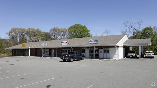
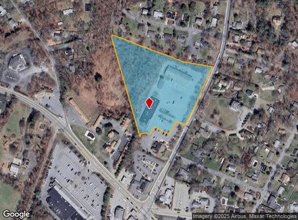
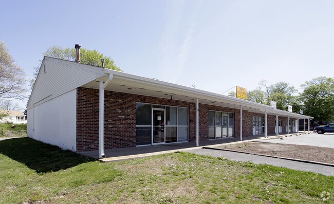
Property Record
14 Manomet Point Rd, Plymouth, MA 02360
NEARBY LISTINGS FOR SALE OR LEASE
-
-
View all Plymouth listings for sale on LoopNet.com
Property Detail
14 Manomet Point Rd
PLYM-000046-000000-000015-000001
Plymouth
Commercialnec
Massachusetts
X
15-1
25023C0391L
4.69 AC
2025
Route 3 South
2025
Boston
530802
Boston-Cambridge-Newton, MA-NH
DEMOGRAPHICS near 14 Manomet Point Rd
1 Mile
3 Mile
5 Mile
2024 Total Population
3,327
12,811
23,345
2029 Population
3,384
13,095
23,789
Pop Growth 2024-2029
+ 1.71%
+ 2.22%
+ 1.90%
Average Age
44
47
48
2024 Total Households
1,353
5,417
9,536
HH Growth 2024-2029
+ 1.70%
+ 2.22%
+ 2.03%
Median Household Inc
$111,263
$116,269
$114,352
Avg Household Size
2.40
2.30
2.30
2024 Avg HH Vehicles
2.00
2.00
2.00
Median Home Value
$462,652
$493,176
$533,778
Median Year Built
1967
1981
1986
Nearby Places
Map Layers
Map Styles
 Street
 Aerial
- Restaurants
- Banks
- Shops
- Fitness
- Groceries
PUBLIC TRANSPORTATION
AIRPORT
General Edward Lawrence Logan International
DRIVE
WALK
Distance
General Edward Lawrence Logan International
69 min
48.9 mi
Freight Ports
Port of New Bedford Harbor
DRIVE
WALK
Distance
Port of New Bedford Harbor
60 min
40.5 mi
Nearby Properties
Address
Land Use
TOTAL SIZE
Lot Size
Zoning
Address
Land Use
TOTAL SIZE
Lot Size
Zoning
61,536 SF
20 AC
R25
Address
Land Use
TOTAL SIZE
Lot Size
Zoning
5.91 AC
R25
Address
Land Use
TOTAL SIZE
Lot Size
Zoning
43,242 SF
10 AC
R20S
Address
Land Use
TOTAL SIZE
Lot Size
Zoning
95.90 AC
RR
Address
Land Use
TOTAL SIZE
Lot Size
Zoning
34,228 SF
4.35 AC
GC
Address
Land Use
TOTAL SIZE
Lot Size
Zoning
44.09 AC
R25
Address
Land Use
TOTAL SIZE
Lot Size
Zoning
16.17 AC
R20S
Address
Land Use
TOTAL SIZE
Lot Size
Zoning
7.87 AC
R25
Address
Land Use
TOTAL SIZE
Lot Size
Zoning
18,014 SF
1.29 AC
R25
Address
Land Use
TOTAL SIZE
Lot Size
Zoning
5,428 SF
2.63 AC
R20M
Address
Land Use
TOTAL SIZE
Lot Size
Zoning
9,184 SF
0.52 AC
R20S
Address
Land Use
TOTAL SIZE
Lot Size
Zoning
10,608 SF
1.62 AC
NC
Address
Land Use
TOTAL SIZE
Lot Size
Zoning
250.78 AC
RR
Address
Land Use
TOTAL SIZE
Lot Size
Zoning
4,628 SF
1.87 AC
R20S
Address
Land Use
TOTAL SIZE
Lot Size
Zoning
3.02 AC
GC
Address
Land Use
TOTAL SIZE
Lot Size
Zoning
768 SF
126.23 AC
R25
Address
Land Use
TOTAL SIZE
Lot Size
Zoning
163.39 AC
RR
Address
Land Use
TOTAL SIZE
Lot Size
Zoning
0.75 AC
R20S
Address
Land Use
TOTAL SIZE
Lot Size
Zoning
2,661 SF
1.60 AC
R20S
Address
Land Use
TOTAL SIZE
Lot Size
Zoning
15,309 SF
1.33 AC
R25
Address
Land Use
TOTAL SIZE
Lot Size
Zoning
1.27 AC
R20S
Address
Land Use
TOTAL SIZE
Lot Size
Zoning
7.14 AC
RR
Address
Land Use
TOTAL SIZE
Lot Size
Zoning
16.62 AC
RR
Address
Land Use
TOTAL SIZE
Lot Size
Zoning
6,866 SF
0.77 AC
R20S
Address
Land Use
TOTAL SIZE
Lot Size
Zoning
12,286 SF
0.87 AC
GC
Address
Land Use
TOTAL SIZE
Lot Size
Zoning
72.01 AC
RR
Address
Land Use
TOTAL SIZE
Lot Size
Zoning
1,890 SF
307.32 AC
RR
Address
Land Use
TOTAL SIZE
Lot Size
Zoning
5,766 SF
0.48 AC
GC
Address
Land Use
TOTAL SIZE
Lot Size
Zoning
6,022 SF
1.06 AC
GC
The World's #1 Commercial Real Estate Marketplace
Connect with us
© 2025 CoStar Group
The information above has been obtained from sources believed reliable. While we do not doubt its accuracy we have not verified it and make no guarantee, warranty or representation about it. It is your responsibility to independently confirm its accuracy and completeness. Any projections, opinions, assumptions, or estimates used are for example only and do not represent the current or future performance of the property. The value of this transaction to you depends on tax and other factors which should be evaluated by your tax, financial, and legal advisors. You and your advisors should conduct a careful, independent investigation of the property to determine to your satisfaction the suitability of the property for your needs.