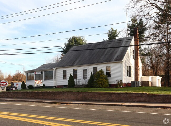
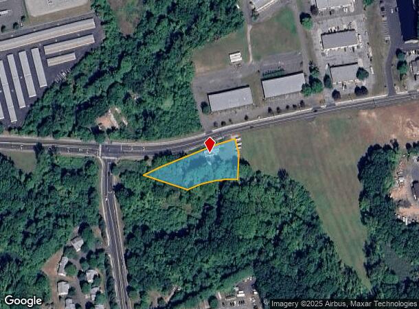
Property Record
12 Moody Rd, Enfield, CT 06082

NEARBY LISTINGS FOR SALE OR LEASE
Property Detail
12 Moody Rd
ENFI-000075-000000-000032
Hartford
Commercialbuilding
Connecticut
AE
32
09003C0231F
1.19 AC
2025
Enfield
2025
Hartford
480800
Hartford-West Hartford-East Hartford, CT
1,906 SF
DEMOGRAPHICS near 12 Moody Rd
1 Mile
3 Mile
5 Mile
2024 Total Population
3,448
38,379
81,948
2029 Population
3,394
38,184
81,403
Pop Growth 2024-2029
(1.57%)
(0.51%)
(0.67%)
Average Age
45
42
43
2024 Total Households
1,593
14,965
30,521
HH Growth 2024-2029
(1.82%)
(0.74%)
(0.88%)
Median Household Inc
$90,287
$87,505
$95,541
Avg Household Size
2.10
2.30
2.40
2024 Avg HH Vehicles
2.00
2.00
2.00
Median Home Value
$233,307
$234,235
$271,139
Median Year Built
1971
1959
1963
Nearby Places
Map Layers
Map Styles
 Street
 Aerial
- Restaurants
- Banks
- Shops
- Fitness
- Groceries
PUBLIC TRANSPORTATION
COMMUTER RAIL
Windsor Locks (Hartford Line - CT Rail (CTRail))
DRIVE
WALK
Distance
Windsor Locks (Hartford Line - CT Rail (CTRail))
13 min
8.9 mi
Springfield (Amtrak Hartford Line - Amtrak, Hartford Line - Amtrak, Lake Shore Limited - Amtrak, Northeast Regional - Amtrak, Valley Flyer - Amtrak, Vermonter - Amtrak)
DRIVE
WALK
Distance
Springfield (Amtrak Hartford Line - Amtrak, Hartford Line - Amtrak, Lake Shore Limited - Amtrak, Northeast Regional - Amtrak, Valley Flyer - Amtrak, Vermonter - Amtrak)
14 min
9.7 mi
AIRPORT
Bradley International
DRIVE
WALK
Distance
Bradley International
25 min
10.2 mi
Freight Ports
Port of New Haven
DRIVE
WALK
Distance
Port of New Haven
76 min
58.4 mi
Nearby Properties
Address
Land Use
TOTAL SIZE
Lot Size
Zoning
Address
Land Use
TOTAL SIZE
Lot Size
Zoning
179,293 SF
51.07 AC
HR33
Address
Land Use
TOTAL SIZE
Lot Size
Zoning
69.62 AC
MFHD
Address
Land Use
TOTAL SIZE
Lot Size
Zoning
370.78 AC
R88
Address
Land Use
TOTAL SIZE
Lot Size
Zoning
283.30 AC
R88
Address
Land Use
TOTAL SIZE
Lot Size
Zoning
166,268 SF
36.70 AC
R44
Address
Land Use
TOTAL SIZE
Lot Size
Zoning
500,000 SF
71.20 AC
I-1
Address
Land Use
TOTAL SIZE
Lot Size
Zoning
201,978 SF
53.95 AC
R88
Address
Land Use
TOTAL SIZE
Lot Size
Zoning
121.07 AC
I-1
Address
Land Use
TOTAL SIZE
Lot Size
Zoning
32.97 AC
BR
Address
Land Use
TOTAL SIZE
Lot Size
Zoning
65.52 AC
BR
Address
Land Use
TOTAL SIZE
Lot Size
Zoning
24.27 AC
SDD
Address
Land Use
TOTAL SIZE
Lot Size
Zoning
32.44 AC
BR
Address
Land Use
TOTAL SIZE
Lot Size
Zoning
49.16 AC
I-1
Address
Land Use
TOTAL SIZE
Lot Size
Zoning
319,054 SF
30.02 AC
I-P
Address
Land Use
TOTAL SIZE
Lot Size
Zoning
36.97 AC
I-1
Address
Land Use
TOTAL SIZE
Lot Size
Zoning
211,256 SF
41.58 AC
R33
Address
Land Use
TOTAL SIZE
Lot Size
Zoning
121 AC
A-1
Address
Land Use
TOTAL SIZE
Lot Size
Zoning
26.82 AC
HR33
Address
Land Use
TOTAL SIZE
Lot Size
Zoning
24.92 AC
BL
Address
Land Use
TOTAL SIZE
Lot Size
Zoning
13.87 AC
BR
Address
Land Use
TOTAL SIZE
Lot Size
Zoning
13.78 AC
BR
Address
Land Use
TOTAL SIZE
Lot Size
Zoning
1.87 AC
BP
Address
Land Use
TOTAL SIZE
Lot Size
Zoning
19.36 AC
BR
Address
Land Use
TOTAL SIZE
Lot Size
Zoning
144,625 SF
19 AC
BR
Address
Land Use
TOTAL SIZE
Lot Size
Zoning
23,660 SF
9.28 AC
RA1
Address
Land Use
TOTAL SIZE
Lot Size
Zoning
12 AC
HR33
Address
Land Use
TOTAL SIZE
Lot Size
Zoning
17.34 AC
R44
Address
Land Use
TOTAL SIZE
Lot Size
Zoning
91,735 SF
9.28 AC
RA1
Address
Land Use
TOTAL SIZE
Lot Size
Zoning
54.05 AC
I-1
Address
Land Use
TOTAL SIZE
Lot Size
Zoning
21.97 AC
I-1
The World's #1 Commercial Real Estate Marketplace
Connect with us
© 2026 CoStar Group
The information above has been obtained from sources believed reliable. While we do not doubt its accuracy we have not verified it and make no guarantee, warranty or representation about it. It is your responsibility to independently confirm its accuracy and completeness. Any projections, opinions, assumptions, or estimates used are for example only and do not represent the current or future performance of the property. The value of this transaction to you depends on tax and other factors which should be evaluated by your tax, financial, and legal advisors. You and your advisors should conduct a careful, independent investigation of the property to determine to your satisfaction the suitability of the property for your needs.