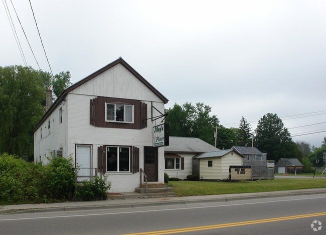
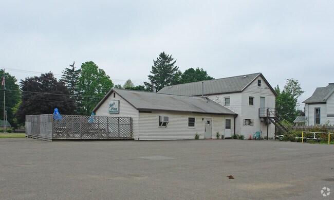
Property Record
12 N Main St, Cassadaga, NY 14718

NEARBY LISTINGS FOR SALE OR LEASE
-
-
View all Cassadaga listings for sale on LoopNet.com
Property Detail
12 N Main St
Jamestown-Dunkirk-Fredonia, NY
OLD APN: 066801 104-2-22
066801-182-017-0001-030-000
Chautauqua
Restaurantbuilding
New York
2025
30.000
2024
0.49 AC
036402
New York West Area
3,480 SF
Other Market Areas
DEMOGRAPHICS near 12 N Main St
1 Mile
3 Mile
5 Mile
2024 Total Population
933
1,866
3,649
2029 Population
900
1,815
3,574
Pop Growth 2024-2029
(3.54%)
(2.73%)
(2.06%)
Average Age
46
46
45
2024 Total Households
428
827
1,559
HH Growth 2024-2029
(3.74%)
(3.02%)
(2.31%)
Median Household Inc
$48,823
$54,732
$62,315
Avg Household Size
2.20
2.20
2.30
2024 Avg HH Vehicles
2.00
2.00
2.00
Median Home Value
$102,033
$109,756
$119,717
Median Year Built
1948
1953
1962
Nearby Places
Map Layers
Map Styles
 Street
 Aerial
- Restaurants
- Banks
- Shops
- Fitness
- Groceries
Nearby Properties
Address
Land Use
TOTAL SIZE
Lot Size
Zoning
Address
Land Use
TOTAL SIZE
Lot Size
Zoning
27,047 SF
8 AC
02 - SINGL
Address
Land Use
TOTAL SIZE
Lot Size
Zoning
36.30 AC
Address
Land Use
TOTAL SIZE
Lot Size
Zoning
43.20 AC
Address
Land Use
TOTAL SIZE
Lot Size
Zoning
6,840 SF
0.60 AC
02 - SINGL
Address
Land Use
TOTAL SIZE
Lot Size
Zoning
8,680 SF
0.96 AC
02 - SINGL
Address
Land Use
TOTAL SIZE
Lot Size
Zoning
1,788 SF
104 AC
04
Address
Land Use
TOTAL SIZE
Lot Size
Zoning
2,652 SF
1.06 AC
02 - SINGL
Address
Land Use
TOTAL SIZE
Lot Size
Zoning
3,895 SF
10.50 AC
05 - COMME
Address
Land Use
TOTAL SIZE
Lot Size
Zoning
720 SF
1.80 AC
04 - FARM
Address
Land Use
TOTAL SIZE
Lot Size
Zoning
5,120 SF
10.90 AC
04 - FARM
Address
Land Use
TOTAL SIZE
Lot Size
Zoning
7,037 SF
0.66 AC
02 - SINGL
Address
Land Use
TOTAL SIZE
Lot Size
Zoning
5,286 SF
1.22 AC
02 - SINGL
Address
Land Use
TOTAL SIZE
Lot Size
Zoning
1,536 SF
211 AC
04 - FARM
Address
Land Use
TOTAL SIZE
Lot Size
Zoning
8,480 SF
13.60 AC
Address
Land Use
TOTAL SIZE
Lot Size
Zoning
910 SF
2.30 AC
Address
Land Use
TOTAL SIZE
Lot Size
Zoning
0.25 AC
02 - SINGL
Address
Land Use
TOTAL SIZE
Lot Size
Zoning
952 SF
4.80 AC
Address
Land Use
TOTAL SIZE
Lot Size
Zoning
181 AC
04 - FARM
Address
Land Use
TOTAL SIZE
Lot Size
Zoning
2,600 SF
1 AC
02 - SINGL
Address
Land Use
TOTAL SIZE
Lot Size
Zoning
4,800 SF
0.60 AC
05 - COMME
Address
Land Use
TOTAL SIZE
Lot Size
Zoning
4,040 SF
0.63 AC
02 - SINGL
Address
Land Use
TOTAL SIZE
Lot Size
Zoning
3,278 SF
0.65 AC
02 - SINGL
Address
Land Use
TOTAL SIZE
Lot Size
Zoning
12,492 SF
2 AC
05 - COMME
Address
Land Use
TOTAL SIZE
Lot Size
Zoning
10,192 SF
0.45 AC
06 - INDUS
Address
Land Use
TOTAL SIZE
Lot Size
Zoning
164 AC
04 - FARM
Address
Land Use
TOTAL SIZE
Lot Size
Zoning
39.30 AC
04 - FARM
Address
Land Use
TOTAL SIZE
Lot Size
Zoning
1,456 SF
22.60 AC
04 - FARM
Address
Land Use
TOTAL SIZE
Lot Size
Zoning
1,152 SF
0.27 AC
05 - COMME
Address
Land Use
TOTAL SIZE
Lot Size
Zoning
11,084 SF
4.80 AC
02 - SINGL
Address
Land Use
TOTAL SIZE
Lot Size
Zoning
200 SF
6.50 AC
04 - FARM
The World's #1 Commercial Real Estate Marketplace
Connect with us
© 2026 CoStar Group
The information above has been obtained from sources believed reliable. While we do not doubt its accuracy we have not verified it and make no guarantee, warranty or representation about it. It is your responsibility to independently confirm its accuracy and completeness. Any projections, opinions, assumptions, or estimates used are for example only and do not represent the current or future performance of the property. The value of this transaction to you depends on tax and other factors which should be evaluated by your tax, financial, and legal advisors. You and your advisors should conduct a careful, independent investigation of the property to determine to your satisfaction the suitability of the property for your needs.