Property Record
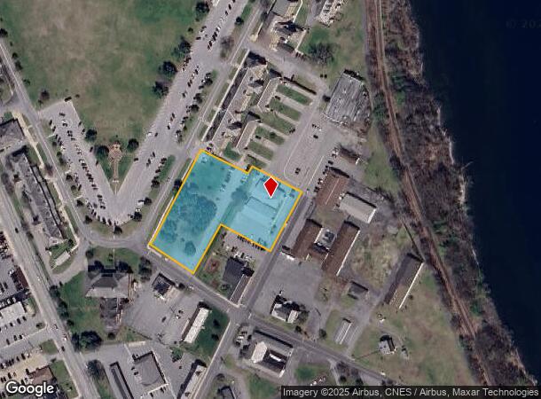
12 New York Rd, Plattsburgh, NY 12903
NEARBY LISTINGS FOR SALE OR LEASE
-
-
View all Plattsburgh listings for sale on LoopNet.com
Property Detail
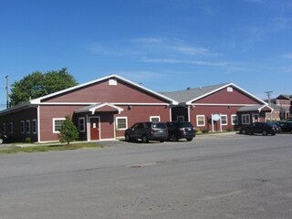
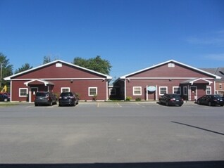
12 New York Rd
Officebuilding
Clinton
X
New York
36019C0612E
9.002
2025
2.15 AC
2024
Other Market Areas
103200
Plattsburgh, NY
8,690 SF
091300-221-012-0002-009-002-0000
DEMOGRAPHICS near 12 New York Rd
1 Mile
3 Mile
5 Mile
2024 Total Population
6,495
21,511
28,848
2029 Population
6,478
21,433
28,737
Pop Growth 2024-2029
(0.26%)
(0.36%)
(0.38%)
Average Age
43
42
42
2024 Total Households
3,330
10,383
13,404
HH Growth 2024-2029
(0.30%)
(0.39%)
(0.43%)
Median Household Inc
$45,725
$52,605
$54,751
Avg Household Size
1.80
2.00
2.10
2024 Avg HH Vehicles
1.00
1.00
1.00
Median Home Value
$137,635
$154,245
$154,697
Median Year Built
1965
1968
1970
Nearby Places
- Restaurants
- Banks
- Shops
- Fitness
- Groceries
PUBLIC TRANSPORTATION
COMMUTER RAIL
Plattsburgh Amtrak Station (Adirondack - Amtrak)
DRIVE
WALK
Distance
Plattsburgh Amtrak Station (Adirondack - Amtrak)
3 min
1.6 mi
AIRPORT
Plattsburgh International
DRIVE
WALK
Distance
Plattsburgh International
5 min
2.4 mi
Patrick Leahy Burlington International
DRIVE
WALK
Distance
Patrick Leahy Burlington International
69 min
32.4 mi
Freight Ports
Montreal
DRIVE
WALK
Distance
Montreal
89 min
66.8 mi
Nearby Properties
Address
Land Use
TOTAL SIZE
Lot Size
Zoning
Address
Land Use
TOTAL SIZE
Lot Size
Zoning
103.84 AC
Address
Land Use
TOTAL SIZE
Lot Size
Zoning
404,903 SF
40.60 AC
03 - MULTI
Address
Land Use
TOTAL SIZE
Lot Size
Zoning
800 SF
776.23 AC
A1
Address
Land Use
TOTAL SIZE
Lot Size
Zoning
131,558 SF
53.50 AC
T5
Address
Land Use
TOTAL SIZE
Lot Size
Zoning
88,880 SF
5.73 AC
I
Address
Land Use
TOTAL SIZE
Lot Size
Zoning
3,545 SF
17.30 AC
06 - INDUS
Address
Land Use
TOTAL SIZE
Lot Size
Zoning
15.80 AC
Address
Land Use
TOTAL SIZE
Lot Size
Zoning
121,465 SF
92 AC
R-2
Address
Land Use
TOTAL SIZE
Lot Size
Zoning
112,400 SF
13.20 AC
I
Address
Land Use
TOTAL SIZE
Lot Size
Zoning
87,442 SF
5.32 AC
02 - SINGL
Address
Land Use
TOTAL SIZE
Lot Size
Zoning
35,562 SF
204.40 AC
LC_OS
Address
Land Use
TOTAL SIZE
Lot Size
Zoning
83,261 SF
24.35 AC
T5
Address
Land Use
TOTAL SIZE
Lot Size
Zoning
73,095 SF
6.28 AC
T4
Address
Land Use
TOTAL SIZE
Lot Size
Zoning
167 AC
02 - SINGL
Address
Land Use
TOTAL SIZE
Lot Size
Zoning
101,758 SF
5.64 AC
T5
Address
Land Use
TOTAL SIZE
Lot Size
Zoning
117,847 SF
47.30 AC
00
Address
Land Use
TOTAL SIZE
Lot Size
Zoning
148,340 SF
5.67 AC
03 - MULTI
Address
Land Use
TOTAL SIZE
Lot Size
Zoning
243,951 SF
21 AC
06 - INDUS
Address
Land Use
TOTAL SIZE
Lot Size
Zoning
965,099 SF
113.70 AC
06 - INDUS
Address
Land Use
TOTAL SIZE
Lot Size
Zoning
578,793 SF
75.50 AC
T5
Address
Land Use
TOTAL SIZE
Lot Size
Zoning
218,230 SF
38.92 AC
I
Address
Land Use
TOTAL SIZE
Lot Size
Zoning
87,939 SF
8.20 AC
T5
Address
Land Use
TOTAL SIZE
Lot Size
Zoning
64,343 SF
2.30 AC
C
Address
Land Use
TOTAL SIZE
Lot Size
Zoning
4,992 SF
13.20 AC
03 - MULTI
Address
Land Use
TOTAL SIZE
Lot Size
Zoning
11,910 SF
3.70 AC
05 - COMME
Address
Land Use
TOTAL SIZE
Lot Size
Zoning
126,842 SF
10 AC
T5
Address
Land Use
TOTAL SIZE
Lot Size
Zoning
84,193 SF
10.60 AC
03 - MULTI
Address
Land Use
TOTAL SIZE
Lot Size
Zoning
59,670 SF
0.50 AC
03 - MULTI
Address
Land Use
TOTAL SIZE
Lot Size
Zoning
210,800 SF
2.42 AC
I
Address
Land Use
TOTAL SIZE
Lot Size
Zoning
229,741 SF
10.90 AC
06 - INDUS
The World's #1 Commercial Real Estate Marketplace
Connect with us
© 2025 CoStar Group
The information above has been obtained from sources believed reliable. While we do not doubt its accuracy we have not verified it and make no guarantee, warranty or representation about it. It is your responsibility to independently confirm its accuracy and completeness. Any projections, opinions, assumptions, or estimates used are for example only and do not represent the current or future performance of the property. The value of this transaction to you depends on tax and other factors which should be evaluated by your tax, financial, and legal advisors. You and your advisors should conduct a careful, independent investigation of the property to determine to your satisfaction the suitability of the property for your needs.