Property Record
12 Plainfield Rd, Canterbury, CT 06331
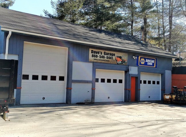

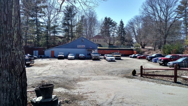
Property Detail
12 Plainfield Rd
CANT-000060-000000-000003-A000000
Northeastern Ct
Commercialbuilding
Connecticut
2025
2.15 AC
2025
Windham County
906100
Hartford
2,646 SF
Willimantic, CT
NEARBY LISTINGS FOR SALE OR LEASE
-
-
View all Canterbury listings for sale on LoopNet.com
DEMOGRAPHICS near 12 Plainfield Rd
1 mile
3 mile
5 mile
2025 Total Population
838
10,246
21,362
2030 Population
852
10,443
21,724
Pop Growth 2025-2030
+ 1.67%
+ 1.92%
+ 1.69%
Average Age
44
42
43
2025 Total Households
341
4,188
8,523
HH Growth 2025-2030
+ 1.47%
+ 1.93%
+ 1.72%
Median Household Inc
$77,678
$76,779
$77,600
Avg Household Size
2.50
2.40
2.50
2025 Avg HH Vehicles
2.00
2.00
2.00
Median Home Value
$264,374
$280,083
$289,956
Median Year Built
1969
1970
1973
Nearby Places
Map Layers
Map Styles
 Street
 Aerial
Transit
 Traffic
 Biking
Places
Listings with unknown addresses are not visible on the map
- Restaurants
- Banks
- Shops
- Fitness
- Groceries
PUBLIC TRANSPORTATION
AIRPORT
Rhode Island Tf Green International
Drive
Walk
Distance
Rhode Island Tf Green International
57 min
41.8 mi
Freight Ports
Port of Davisville, RI
Drive
Walk
Distance
Port of Davisville, RI
65 min
37.1 mi
SALE & LEASE HISTORY
LISTING DATE
SALE/LEASE

Sep 23, 2016
For Sale
Nearby Properties
Address
Land Use
TOTAL SIZE
Lot Size
Zoning
Address
Land Use
TOTAL SIZE
Lot Size
Zoning
202.19 AC
IND
Address
Land Use
TOTAL SIZE
Lot Size
Zoning
202,044 SF
52.20 AC
I
Address
Land Use
TOTAL SIZE
Lot Size
Zoning
3 AC
BR
Address
Land Use
TOTAL SIZE
Lot Size
Zoning
138,994 SF
35.90 AC
BR
Address
Land Use
TOTAL SIZE
Lot Size
Zoning
54,304 SF
28.41 AC
IND-2
Address
Land Use
TOTAL SIZE
Lot Size
Zoning
23.61 AC
R60
Address
Land Use
TOTAL SIZE
Lot Size
Zoning
15.20 AC
C
Address
Land Use
TOTAL SIZE
Lot Size
Zoning
800 SF
15.50 AC
Address
Land Use
TOTAL SIZE
Lot Size
Zoning
14,082 SF
1.66 AC
R60
Address
Land Use
TOTAL SIZE
Lot Size
Zoning
6.26 AC
C
Address
Land Use
TOTAL SIZE
Lot Size
Zoning
Address
Land Use
TOTAL SIZE
Lot Size
Zoning
21,084 SF
1.70 AC
B-C
Address
Land Use
TOTAL SIZE
Lot Size
Zoning
80,180 SF
9.66 AC
IND-1
Address
Land Use
TOTAL SIZE
Lot Size
Zoning
11.40 AC
CI
Address
Land Use
TOTAL SIZE
Lot Size
Zoning
26,796 SF
2.89 AC
I
Address
Land Use
TOTAL SIZE
Lot Size
Zoning
119.90 AC
OSPR
Address
Land Use
TOTAL SIZE
Lot Size
Zoning
15,788 SF
0.43 AC
B-C
Address
Land Use
TOTAL SIZE
Lot Size
Zoning
134.78 AC
Address
Land Use
TOTAL SIZE
Lot Size
Zoning
52.63 AC
IND-1
Address
Land Use
TOTAL SIZE
Lot Size
Zoning
10,000 SF
6.25 AC
IND
Address
Land Use
TOTAL SIZE
Lot Size
Zoning
1.99 AC
B-R
Address
Land Use
TOTAL SIZE
Lot Size
Zoning
5,508 SF
59.80 AC
C2
Address
Land Use
TOTAL SIZE
Lot Size
Zoning
44.90 AC
I
Address
Land Use
TOTAL SIZE
Lot Size
Zoning
50 AC
C1
Address
Land Use
TOTAL SIZE
Lot Size
Zoning
33,202 SF
23.66 AC
I
Address
Land Use
TOTAL SIZE
Lot Size
Zoning
25,276 SF
2.61 AC
BR
Address
Land Use
TOTAL SIZE
Lot Size
Zoning
6.53 AC
BRM
Address
Land Use
TOTAL SIZE
Lot Size
Zoning
6,240 SF
2 AC
BRC
Address
Land Use
TOTAL SIZE
Lot Size
Zoning
7,538 SF
1.46 AC
B-C
Address
Land Use
TOTAL SIZE
Lot Size
Zoning
2.50 AC
The World's #1 Commercial Real Estate Marketplace
Connect with us
© 2026 CoStar Group
The information above has been obtained from sources believed reliable. While we do not doubt its accuracy we have not verified it and make no guarantee, warranty or representation about it. It is your responsibility to independently confirm its accuracy and completeness. Any projections, opinions, assumptions, or estimates used are for example only and do not represent the current or future performance of the property. The value of this transaction to you depends on tax and other factors which should be evaluated by your tax, financial, and legal advisors. You and your advisors should conduct a careful, independent investigation of the property to determine to your satisfaction the suitability of the property for your needs.