Property Record
12 Randy Johnson St, Superior, WI 54880

NEARBY LISTINGS FOR SALE OR LEASE
-
-
View all Superior listings for sale on LoopNet.com
Property Detail
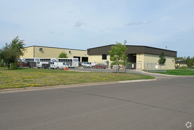
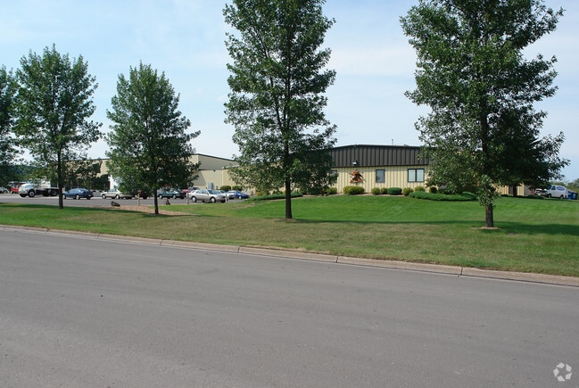
12 Randy Johnson St
Duluth, MN-WI
SUPERIOR INDUSTRIAL PARK LOTS 1, 2 & 3, BL 3 #936751
02-802-07115-00
Douglas
Commercialnec
Wisconsin
X
1,2,3
27137C3880E
3.46 AC
2024
Superior
2024
Duluth
020800
DEMOGRAPHICS near 12 Randy Johnson St
1 Mile
3 Mile
5 Mile
2024 Total Population
3,612
23,922
33,395
2029 Population
3,583
23,639
32,989
Pop Growth 2024-2029
(0.80%)
(1.18%)
(1.22%)
Average Age
38
40
40
2024 Total Households
1,322
10,542
14,867
HH Growth 2024-2029
(0.98%)
(1.23%)
(1.27%)
Median Household Inc
$65,614
$52,201
$51,834
Avg Household Size
2.20
2.10
2.10
2024 Avg HH Vehicles
2.00
2.00
2.00
Median Home Value
$158,861
$149,783
$149,644
Median Year Built
1961
1955
1949
Nearby Places
Map Layers
Map Styles
 Street
 Aerial
- Restaurants
- Banks
- Shops
- Fitness
- Groceries
PUBLIC TRANSPORTATION
AIRPORT
Duluth International
DRIVE
WALK
Distance
Duluth International
31 min
15.2 mi
Freight Ports
Port Milwaukee
DRIVE
WALK
Distance
Port Milwaukee
444 min
393.1 mi
Nearby Properties
Address
Land Use
TOTAL SIZE
Lot Size
Zoning
Address
Land Use
TOTAL SIZE
Lot Size
Zoning
50.82 AC
M2
Address
Land Use
TOTAL SIZE
Lot Size
Zoning
2.81 AC
PDD
Address
Land Use
TOTAL SIZE
Lot Size
Zoning
1.45 AC
C3
Address
Land Use
TOTAL SIZE
Lot Size
Zoning
135.91 AC
M2
Address
Land Use
TOTAL SIZE
Lot Size
Zoning
1.36 AC
C2
Address
Land Use
TOTAL SIZE
Lot Size
Zoning
21.96 AC
Address
Land Use
TOTAL SIZE
Lot Size
Zoning
4.17 AC
C2
Address
Land Use
TOTAL SIZE
Lot Size
Zoning
8.50 AC
W1
Address
Land Use
TOTAL SIZE
Lot Size
Zoning
28.37 AC
W1
Address
Land Use
TOTAL SIZE
Lot Size
Zoning
2.47 AC
C2
Address
Land Use
TOTAL SIZE
Lot Size
Zoning
6.94 AC
Address
Land Use
TOTAL SIZE
Lot Size
Zoning
27.99 AC
C2
Address
Land Use
TOTAL SIZE
Lot Size
Zoning
52.06 AC
M2
Address
Land Use
TOTAL SIZE
Lot Size
Zoning
2 AC
R3
Address
Land Use
TOTAL SIZE
Lot Size
Zoning
6.01 AC
M2
Address
Land Use
TOTAL SIZE
Lot Size
Zoning
0.68 AC
R3
Address
Land Use
TOTAL SIZE
Lot Size
Zoning
2.44 AC
C2
Address
Land Use
TOTAL SIZE
Lot Size
Zoning
20.01 AC
Address
Land Use
TOTAL SIZE
Lot Size
Zoning
1.34 AC
Address
Land Use
TOTAL SIZE
Lot Size
Zoning
3.42 AC
R3
Address
Land Use
TOTAL SIZE
Lot Size
Zoning
7.05 AC
M2
Address
Land Use
TOTAL SIZE
Lot Size
Zoning
9.84 AC
C2
Address
Land Use
TOTAL SIZE
Lot Size
Zoning
24.54 AC
W1
Address
Land Use
TOTAL SIZE
Lot Size
Zoning
11.43 AC
R3
Address
Land Use
TOTAL SIZE
Lot Size
Zoning
1.97 AC
PDD
Address
Land Use
TOTAL SIZE
Lot Size
Zoning
Address
Land Use
TOTAL SIZE
Lot Size
Zoning
1.41 AC
C4
Address
Land Use
TOTAL SIZE
Lot Size
Zoning
3,252 SF
66.01 AC
Address
Land Use
TOTAL SIZE
Lot Size
Zoning
3.54 AC
W1
Address
Land Use
TOTAL SIZE
Lot Size
Zoning
7.50 AC
R3
The World's #1 Commercial Real Estate Marketplace
Connect with us
© 2025 CoStar Group
The information above has been obtained from sources believed reliable. While we do not doubt its accuracy we have not verified it and make no guarantee, warranty or representation about it. It is your responsibility to independently confirm its accuracy and completeness. Any projections, opinions, assumptions, or estimates used are for example only and do not represent the current or future performance of the property. The value of this transaction to you depends on tax and other factors which should be evaluated by your tax, financial, and legal advisors. You and your advisors should conduct a careful, independent investigation of the property to determine to your satisfaction the suitability of the property for your needs.