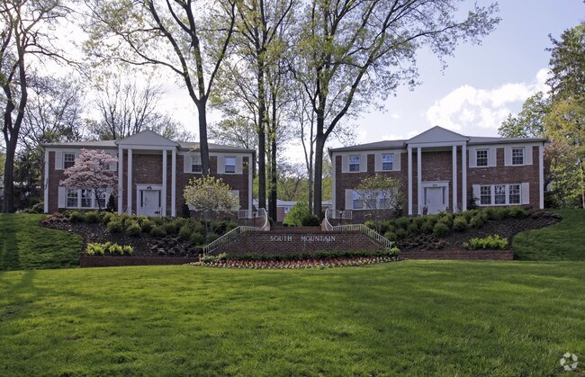
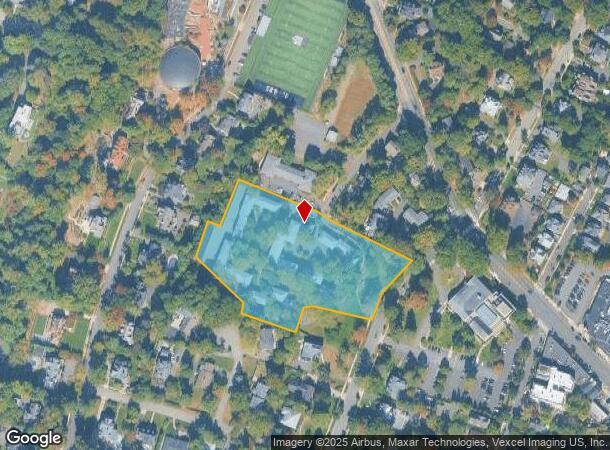
Property Record
12 S Mountain Way, Cedar Grove, NJ 07009

NEARBY LISTINGS FOR SALE OR LEASE
Property Detail
12 S Mountain Way
Newark, NJ-PA
Crestview Gardens
13-00304-0000-00017
3.75 ACRES
Apartment
Essex
X
New Jersey
34013C0103F
17
2023
3.75 AC
2025
Upper Essex County
016900
Northern New Jersey
DEMOGRAPHICS near 12 S Mountain Way
1 Mile
3 Mile
5 Mile
2024 Total Population
18,575
171,335
543,811
2029 Population
18,341
168,629
533,765
Pop Growth 2024-2029
(1.26%)
(1.58%)
(1.85%)
Average Age
41
41
40
2024 Total Households
8,062
64,936
203,388
HH Growth 2024-2029
(1.49%)
(1.75%)
(1.98%)
Median Household Inc
$128,167
$106,054
$83,380
Avg Household Size
2.20
2.50
2.60
2024 Avg HH Vehicles
2.00
2.00
2.00
Median Home Value
$600,211
$498,460
$457,952
Median Year Built
1948
1952
1955
Nearby Places
Map Layers
Map Styles
 Street
 Aerial
- Restaurants
- Banks
- Shops
- Fitness
- Groceries
PUBLIC TRANSPORTATION
COMMUTER RAIL
Walnut Street (Montclair-Boonton Line - NJ Transit Commuter Rail (NJ Transit))
DRIVE
WALK
Distance
Walnut Street (Montclair-Boonton Line - NJ Transit Commuter Rail (NJ Transit))
3 min
1.3 mi
Bay Street (Montclair-Boonton Line - NJ Transit Commuter Rail (NJ Transit))
DRIVE
WALK
Distance
Bay Street (Montclair-Boonton Line - NJ Transit Commuter Rail (NJ Transit))
3 min
1.4 mi
AIRPORT
Newark Liberty International
DRIVE
WALK
Distance
Newark Liberty International
21 min
12.2 mi
LaGuardia
DRIVE
WALK
Distance
LaGuardia
46 min
25.7 mi
John F Kennedy International
DRIVE
WALK
Distance
John F Kennedy International
54 min
33.8 mi
Freight Ports
Port Newark Container Terminal
DRIVE
WALK
Distance
Port Newark Container Terminal
23 min
12.0 mi
Nearby Properties
Address
Land Use
TOTAL SIZE
Lot Size
Zoning
Address
Land Use
TOTAL SIZE
Lot Size
Zoning
33.60 AC
P-C
Address
Land Use
TOTAL SIZE
Lot Size
Zoning
5 AC
H
Address
Land Use
TOTAL SIZE
Lot Size
Zoning
Address
Land Use
TOTAL SIZE
Lot Size
Zoning
1,589 SF
R4
Address
Land Use
TOTAL SIZE
Lot Size
Zoning
12.54 AC
OPRP
Address
Land Use
TOTAL SIZE
Lot Size
Zoning
Address
Land Use
TOTAL SIZE
Lot Size
Zoning
31.36 AC
P-6
Address
Land Use
TOTAL SIZE
Lot Size
Zoning
32.34 AC
RA
Address
Land Use
TOTAL SIZE
Lot Size
Zoning
3.26 AC
PR
Address
Land Use
TOTAL SIZE
Lot Size
Zoning
0.17 AC
BCR1
Address
Land Use
TOTAL SIZE
Lot Size
Zoning
2.22 AC
OB-2
Address
Land Use
TOTAL SIZE
Lot Size
Zoning
1.67 AC
BCR1
Address
Land Use
TOTAL SIZE
Lot Size
Zoning
3.20 AC
BSRD
Address
Land Use
TOTAL SIZE
Lot Size
Zoning
224 SF
0.94 AC
BCR1
Address
Land Use
TOTAL SIZE
Lot Size
Zoning
1.50 AC
RA
Address
Land Use
TOTAL SIZE
Lot Size
Zoning
1.95 AC
RA
Address
Land Use
TOTAL SIZE
Lot Size
Zoning
3.64 AC
R-M
Address
Land Use
TOTAL SIZE
Lot Size
Zoning
364.34 AC
R-1
Address
Land Use
TOTAL SIZE
Lot Size
Zoning
25.88 AC
Address
Land Use
TOTAL SIZE
Lot Size
Zoning
17.90 AC
R-G
Address
Land Use
TOTAL SIZE
Lot Size
Zoning
12.08 AC
R-G
Address
Land Use
TOTAL SIZE
Lot Size
Zoning
1,760 SF
189.03 AC
R-2
Address
Land Use
TOTAL SIZE
Lot Size
Zoning
9.38 AC
R-G
Address
Land Use
TOTAL SIZE
Lot Size
Zoning
5.20 AC
R-H
Address
Land Use
TOTAL SIZE
Lot Size
Zoning
5.74 AC
B-2
Address
Land Use
TOTAL SIZE
Lot Size
Zoning
6.30 AC
B
Address
Land Use
TOTAL SIZE
Lot Size
Zoning
79,668 SF
3.42 AC
0-R
Address
Land Use
TOTAL SIZE
Lot Size
Zoning
31.56 AC
R-3
Address
Land Use
TOTAL SIZE
Lot Size
Zoning
1,832 SF
2.18 AC
R3
Address
Land Use
TOTAL SIZE
Lot Size
Zoning
14.27 AC
RO
The World's #1 Commercial Real Estate Marketplace
Connect with us
© 2025 CoStar Group
The information above has been obtained from sources believed reliable. While we do not doubt its accuracy we have not verified it and make no guarantee, warranty or representation about it. It is your responsibility to independently confirm its accuracy and completeness. Any projections, opinions, assumptions, or estimates used are for example only and do not represent the current or future performance of the property. The value of this transaction to you depends on tax and other factors which should be evaluated by your tax, financial, and legal advisors. You and your advisors should conduct a careful, independent investigation of the property to determine to your satisfaction the suitability of the property for your needs.