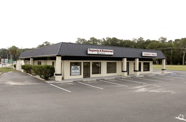
Property Record
12 Savannah Hwy, Beaufort, SC 29906
NEARBY LISTINGS FOR SALE OR LEASE
Property Detail
12 Savannah Hwy
Hilton Head Island-Bluffton-Beaufort, SC
Shell Point Commercial
R112-033-00A-0249-0000
PARCEL A PB143 PG100 FKA LOT 1-WSHELL PT0.06 AC DEDUCTED RD R/W~02/17 AC CHANGED
Storebuilding
Beaufort
2025
South Carolina
2024
1
000503
0.92 AC
5,917 SF
Other Market Areas
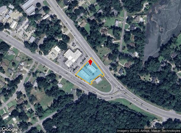
DEMOGRAPHICS near 12 Savannah Hwy
1 Mile
3 Mile
5 Mile
2024 Total Population
3,810
17,661
35,361
2029 Population
4,317
19,659
38,976
Pop Growth 2024-2029
+ 13.31%
+ 11.31%
+ 10.22%
Average Age
38
37
37
2024 Total Households
1,522
7,208
12,686
HH Growth 2024-2029
+ 12.94%
+ 10.86%
+ 10.55%
Median Household Inc
$64,732
$60,259
$58,769
Avg Household Size
2.50
2.40
2.40
2024 Avg HH Vehicles
2.00
2.00
2.00
Median Home Value
$222,197
$248,062
$258,238
Median Year Built
2007
1995
1992
Nearby Places
Map Layers
Map Styles
 Street
 Aerial
- Restaurants
- Banks
- Shops
- Fitness
- Groceries
PUBLIC TRANSPORTATION
AIRPORT
Hilton Head
DRIVE
WALK
Distance
Hilton Head
46 min
33.6 mi
Freight Ports
Georgia Ports - Savannah
DRIVE
WALK
Distance
Georgia Ports - Savannah
55 min
43.0 mi
Nearby Properties
Address
Land Use
TOTAL SIZE
Lot Size
Zoning
Address
Land Use
TOTAL SIZE
Lot Size
Zoning
8,358 SF
21.89 AC
6611
Address
Land Use
TOTAL SIZE
Lot Size
Zoning
243,644 SF
13.23 AC
6601
Address
Land Use
TOTAL SIZE
Lot Size
Zoning
426,516 SF
32.63 AC
6601
Address
Land Use
TOTAL SIZE
Lot Size
Zoning
1,802 SF
21.42 AC
6111
Address
Land Use
TOTAL SIZE
Lot Size
Zoning
22,944 SF
16.59 AC
6101
Address
Land Use
TOTAL SIZE
Lot Size
Zoning
103,282 SF
19.22 AC
Address
Land Use
TOTAL SIZE
Lot Size
Zoning
78,168 SF
11 AC
Address
Land Use
TOTAL SIZE
Lot Size
Zoning
24,024 SF
20.45 AC
6611
Address
Land Use
TOTAL SIZE
Lot Size
Zoning
142,753 SF
47.79 AC
6611
Address
Land Use
TOTAL SIZE
Lot Size
Zoning
116,067 SF
27 AC
6611
Address
Land Use
TOTAL SIZE
Lot Size
Zoning
214,795 SF
24.94 AC
6611
Address
Land Use
TOTAL SIZE
Lot Size
Zoning
1,394 SF
47.49 AC
6611
Address
Land Use
TOTAL SIZE
Lot Size
Zoning
60,440 SF
9.28 AC
6611
Address
Land Use
TOTAL SIZE
Lot Size
Zoning
50,800 SF
4.03 AC
6611
Address
Land Use
TOTAL SIZE
Lot Size
Zoning
37,624 SF
2.42 AC
6611
Address
Land Use
TOTAL SIZE
Lot Size
Zoning
6,024 SF
10.60 AC
6611
Address
Land Use
TOTAL SIZE
Lot Size
Zoning
92,125 SF
10.14 AC
6611
Address
Land Use
TOTAL SIZE
Lot Size
Zoning
67,773 SF
20.19 AC
6611
Address
Land Use
TOTAL SIZE
Lot Size
Zoning
6,784 SF
10.50 AC
6111
Address
Land Use
TOTAL SIZE
Lot Size
Zoning
53,684 SF
24.30 AC
6611
Address
Land Use
TOTAL SIZE
Lot Size
Zoning
53,704 SF
4.76 AC
6611
Address
Land Use
TOTAL SIZE
Lot Size
Zoning
73,938 SF
20.18 AC
4201
Address
Land Use
TOTAL SIZE
Lot Size
Zoning
45,668 SF
9.01 AC
6611
Address
Land Use
TOTAL SIZE
Lot Size
Zoning
11,592 SF
2.48 AC
6611
Address
Land Use
TOTAL SIZE
Lot Size
Zoning
41,664 SF
4.10 AC
Address
Land Use
TOTAL SIZE
Lot Size
Zoning
17,511 SF
6.33 AC
6611
Address
Land Use
TOTAL SIZE
Lot Size
Zoning
416 SF
20.82 AC
6101
Address
Land Use
TOTAL SIZE
Lot Size
Zoning
25,940 SF
15.05 AC
6611
Address
Land Use
TOTAL SIZE
Lot Size
Zoning
2,400 SF
4.77 AC
6611
Address
Land Use
TOTAL SIZE
Lot Size
Zoning
11,424 SF
7.33 AC
4201
The World's #1 Commercial Real Estate Marketplace
Connect with us
© 2025 CoStar Group
The information above has been obtained from sources believed reliable. While we do not doubt its accuracy we have not verified it and make no guarantee, warranty or representation about it. It is your responsibility to independently confirm its accuracy and completeness. Any projections, opinions, assumptions, or estimates used are for example only and do not represent the current or future performance of the property. The value of this transaction to you depends on tax and other factors which should be evaluated by your tax, financial, and legal advisors. You and your advisors should conduct a careful, independent investigation of the property to determine to your satisfaction the suitability of the property for your needs.