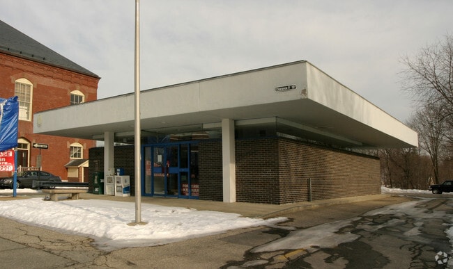
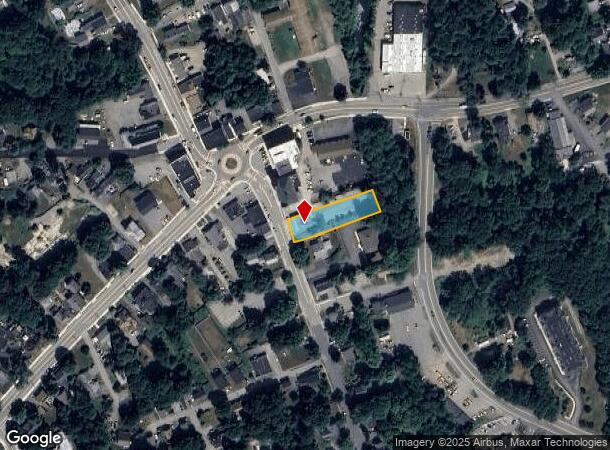
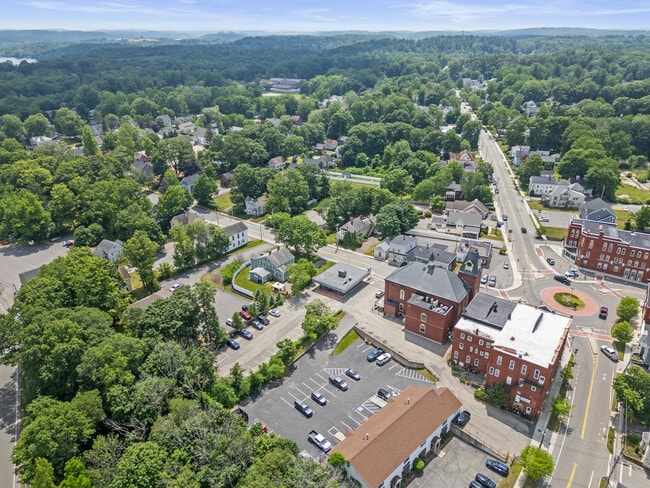
Property Record
12 School St, Merrimac, MA 01860
Current Lease Availabilities
NEARBY LISTINGS FOR SALE OR LEASE
Property Detail
12 School St
MERR-000001-000001-000001
Essex
Restaurantbuilding
Massachusetts
X
1
25009C0084G
0.49 AC
2025
Amesbury/Ipswich
2025
Boston
262100
Boston-Cambridge-Newton, MA-NH
2,924 SF
DEMOGRAPHICS near 12 School St
1 Mile
3 Mile
5 Mile
2024 Total Population
4,150
14,915
55,782
2029 Population
4,179
14,978
55,919
Pop Growth 2024-2029
+ 0.70%
+ 0.42%
+ 0.25%
Average Age
43
43
43
2024 Total Households
1,639
5,696
21,985
HH Growth 2024-2029
+ 0.61%
+ 0.30%
+ 0.06%
Median Household Inc
$89,084
$115,093
$109,062
Avg Household Size
2.50
2.50
2.50
2024 Avg HH Vehicles
2.00
2.00
2.00
Median Home Value
$565,353
$526,267
$479,015
Median Year Built
1987
1984
1975
Nearby Places
- Restaurants
- Banks
- Shops
- Fitness
- Groceries
PUBLIC TRANSPORTATION
COMMUTER RAIL
Haverhill (Haverhill Line - Massachusetts Bay Transportation Authority Commuter Rail (Purple Line))
DRIVE
WALK
Distance
Haverhill (Haverhill Line - Massachusetts Bay Transportation Authority Commuter Rail (Purple Line))
12 min
7.6 mi
Bradford (Haverhill Line - Massachusetts Bay Transportation Authority Commuter Rail (Purple Line))
DRIVE
WALK
Distance
Bradford (Haverhill Line - Massachusetts Bay Transportation Authority Commuter Rail (Purple Line))
13 min
8.0 mi
AIRPORT
Portsmouth International at Pease
DRIVE
WALK
Distance
Portsmouth International at Pease
33 min
23.9 mi
Manchester Boston Regional
DRIVE
WALK
Distance
Manchester Boston Regional
53 min
37.3 mi
Freight Ports
Port of Boston
DRIVE
WALK
Distance
Port of Boston
58 min
44.2 mi
Nearby Properties
Address
Land Use
TOTAL SIZE
Lot Size
Zoning
Address
Land Use
TOTAL SIZE
Lot Size
Zoning
481,367 SF
166.72 AC
Address
Land Use
TOTAL SIZE
Lot Size
Zoning
129.11 AC
RC
Address
Land Use
TOTAL SIZE
Lot Size
Zoning
147,462 SF
10.60 AC
I
Address
Land Use
TOTAL SIZE
Lot Size
Zoning
8.54 AC
RH
Address
Land Use
TOTAL SIZE
Lot Size
Zoning
63,258 SF
8.01 AC
RH
Address
Land Use
TOTAL SIZE
Lot Size
Zoning
74,516 SF
13.40 AC
VR
Address
Land Use
TOTAL SIZE
Lot Size
Zoning
14.35 AC
R20
Address
Land Use
TOTAL SIZE
Lot Size
Zoning
424,000 SF
42.54 AC
I
Address
Land Use
TOTAL SIZE
Lot Size
Zoning
49.70 AC
I
Address
Land Use
TOTAL SIZE
Lot Size
Zoning
77,498 SF
23.60 AC
I
Address
Land Use
TOTAL SIZE
Lot Size
Zoning
6.80 AC
RH
Address
Land Use
TOTAL SIZE
Lot Size
Zoning
78 AC
RES
Address
Land Use
TOTAL SIZE
Lot Size
Zoning
2,520 SF
16.61 AC
OSC
Address
Land Use
TOTAL SIZE
Lot Size
Zoning
10.75 AC
OSC
Address
Land Use
TOTAL SIZE
Lot Size
Zoning
123,024 SF
22.96 AC
I
Address
Land Use
TOTAL SIZE
Lot Size
Zoning
87,720 SF
22.37 AC
OI
Address
Land Use
TOTAL SIZE
Lot Size
Zoning
84,180 SF
6.92 AC
I
Address
Land Use
TOTAL SIZE
Lot Size
Zoning
52,802 SF
12.50 AC
SR
Address
Land Use
TOTAL SIZE
Lot Size
Zoning
130,422 SF
16.95 AC
LIGHT
Address
Land Use
TOTAL SIZE
Lot Size
Zoning
84,171 SF
6.07 AC
I
Address
Land Use
TOTAL SIZE
Lot Size
Zoning
27,648 SF
2.16 AC
VR
Address
Land Use
TOTAL SIZE
Lot Size
Zoning
14,572 SF
5.96 AC
RH
Address
Land Use
TOTAL SIZE
Lot Size
Zoning
53,600 SF
3.75 AC
I
Address
Land Use
TOTAL SIZE
Lot Size
Zoning
1,180 SF
2.21 AC
VR
Address
Land Use
TOTAL SIZE
Lot Size
Zoning
18,478 SF
4.39 AC
RC
Address
Land Use
TOTAL SIZE
Lot Size
Zoning
34,393 SF
4.23 AC
I
Address
Land Use
TOTAL SIZE
Lot Size
Zoning
21,223 SF
12 AC
ICR
Address
Land Use
TOTAL SIZE
Lot Size
Zoning
44,062 SF
7.39 AC
I
Address
Land Use
TOTAL SIZE
Lot Size
Zoning
15,304 SF
9.79 AC
RH
Address
Land Use
TOTAL SIZE
Lot Size
Zoning
13,794 SF
1.41 AC
RC
The World's #1 Commercial Real Estate Marketplace
Connect with us
© 2025 CoStar Group
The information above has been obtained from sources believed reliable. While we do not doubt its accuracy we have not verified it and make no guarantee, warranty or representation about it. It is your responsibility to independently confirm its accuracy and completeness. Any projections, opinions, assumptions, or estimates used are for example only and do not represent the current or future performance of the property. The value of this transaction to you depends on tax and other factors which should be evaluated by your tax, financial, and legal advisors. You and your advisors should conduct a careful, independent investigation of the property to determine to your satisfaction the suitability of the property for your needs.