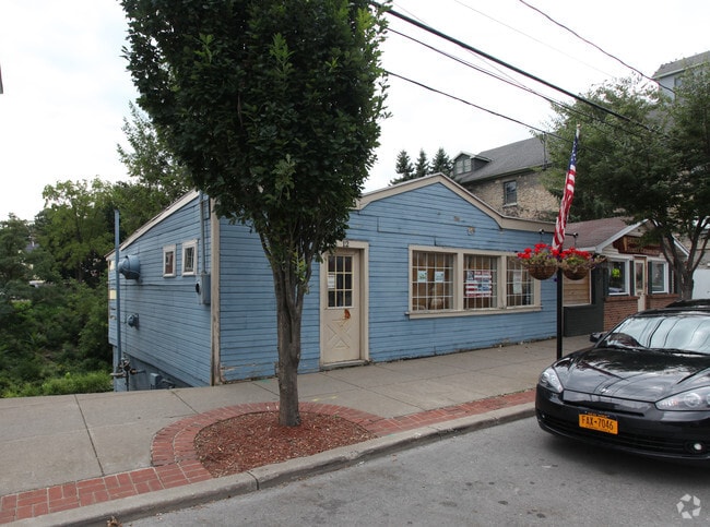
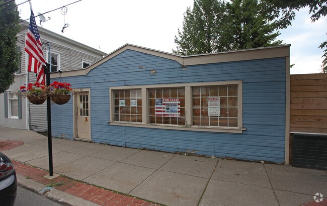
Property Record
12 W Main St, Honeoye Falls, NY 14472
NEARBY LISTINGS FOR SALE OR LEASE
-
-
View all Honeoye Falls listings for lease on LoopNet.com
Property Detail
12 W Main St
Rochester, NY
00-11-05 BALL TRACT
263601-228-430-0001-026-000
Monroe
Commercialacreage
New York
AE
26.000
36055C0504G
0.05 AC
2025
Southeast
2024
Rochester
012401
DEMOGRAPHICS near 12 W Main St
1 Mile
3 Mile
5 Mile
2024 Total Population
3,037
6,964
14,260
2029 Population
3,032
6,888
14,045
Pop Growth 2024-2029
(0.16%)
(1.09%)
(1.51%)
Average Age
43
43
43
2024 Total Households
1,392
2,920
5,855
HH Growth 2024-2029
(0.22%)
(1.06%)
(1.52%)
Median Household Inc
$85,828
$92,865
$92,710
Avg Household Size
2.20
2.40
2.40
2024 Avg HH Vehicles
2.00
2.00
2.00
Median Home Value
$226,804
$244,533
$239,863
Median Year Built
1962
1971
1972
Nearby Places
- Restaurants
- Banks
- Shops
- Fitness
- Groceries
PUBLIC TRANSPORTATION
AIRPORT
Frederick Douglass/Greater Rochester International
DRIVE
WALK
Distance
Frederick Douglass/Greater Rochester International
28 min
17.2 mi
Freight Ports
Albany, NY Port
DRIVE
WALK
Distance
Albany, NY Port
266 min
223.1 mi
SALE & LEASE HISTORY
LISTING DATE
SALE/LEASE

Jul 28, 2017
For Lease
Nearby Properties
Address
Land Use
TOTAL SIZE
Lot Size
Zoning
Address
Land Use
TOTAL SIZE
Lot Size
Zoning
179,600 SF
56.70 AC
02 - SINGL
Address
Land Use
TOTAL SIZE
Lot Size
Zoning
200,000 SF
38.65 AC
RA5
Address
Land Use
TOTAL SIZE
Lot Size
Zoning
16,690 SF
19.56 AC
05 - COMME
Address
Land Use
TOTAL SIZE
Lot Size
Zoning
19,390 SF
11.60 AC
05 - COMME
Address
Land Use
TOTAL SIZE
Lot Size
Zoning
4,436 SF
19.30 AC
02 - SINGL
Address
Land Use
TOTAL SIZE
Lot Size
Zoning
65,594 SF
7.57 AC
05 - COMME
Address
Land Use
TOTAL SIZE
Lot Size
Zoning
1,856 SF
21.90 AC
R
Address
Land Use
TOTAL SIZE
Lot Size
Zoning
54,308 SF
5.90 AC
05 - COMME
Address
Land Use
TOTAL SIZE
Lot Size
Zoning
783 SF
8.01 AC
08 - GOVER
Address
Land Use
TOTAL SIZE
Lot Size
Zoning
73,012 SF
14.75 AC
05 - COMME
Address
Land Use
TOTAL SIZE
Lot Size
Zoning
96,588 SF
37.27 AC
05 - COMME
Address
Land Use
TOTAL SIZE
Lot Size
Zoning
26.28 AC
RA5
Address
Land Use
TOTAL SIZE
Lot Size
Zoning
78,580 SF
12.40 AC
05 - COMME
Address
Land Use
TOTAL SIZE
Lot Size
Zoning
23,360 SF
39.97 AC
04 - FARM
Address
Land Use
TOTAL SIZE
Lot Size
Zoning
18,750 SF
3.71 AC
Address
Land Use
TOTAL SIZE
Lot Size
Zoning
426 AC
04 - FARM
Address
Land Use
TOTAL SIZE
Lot Size
Zoning
18,172 SF
10.09 AC
R30
Address
Land Use
TOTAL SIZE
Lot Size
Zoning
43,360 SF
10.84 AC
05 - COMME
Address
Land Use
TOTAL SIZE
Lot Size
Zoning
576 SF
15.66 AC
A
Address
Land Use
TOTAL SIZE
Lot Size
Zoning
226 AC
04 - FARM
Address
Land Use
TOTAL SIZE
Lot Size
Zoning
12,005 SF
2.42 AC
05 - COMME
Address
Land Use
TOTAL SIZE
Lot Size
Zoning
4,574 SF
5 AC
03 - MULTI
Address
Land Use
TOTAL SIZE
Lot Size
Zoning
3,600 SF
5.12 AC
05 - COMME
Address
Land Use
TOTAL SIZE
Lot Size
Zoning
251 AC
04 - FARM
Address
Land Use
TOTAL SIZE
Lot Size
Zoning
11,242 SF
2.94 AC
05 - COMME
Address
Land Use
TOTAL SIZE
Lot Size
Zoning
9,880 SF
1 AC
Address
Land Use
TOTAL SIZE
Lot Size
Zoning
9,029 SF
5 AC
05 - COMME
Address
Land Use
TOTAL SIZE
Lot Size
Zoning
3 AC
06 - INDUS
Address
Land Use
TOTAL SIZE
Lot Size
Zoning
180.30 AC
04 - FARM
Address
Land Use
TOTAL SIZE
Lot Size
Zoning
194.10 AC
04 - FARM
The World's #1 Commercial Real Estate Marketplace
Connect with us
© 2025 CoStar Group
The information above has been obtained from sources believed reliable. While we do not doubt its accuracy we have not verified it and make no guarantee, warranty or representation about it. It is your responsibility to independently confirm its accuracy and completeness. Any projections, opinions, assumptions, or estimates used are for example only and do not represent the current or future performance of the property. The value of this transaction to you depends on tax and other factors which should be evaluated by your tax, financial, and legal advisors. You and your advisors should conduct a careful, independent investigation of the property to determine to your satisfaction the suitability of the property for your needs.