Property Record
12 W Newport Rd, Lititz, PA 17543
Current Lease Availabilities
NEARBY LISTINGS FOR SALE OR LEASE
Property Detail
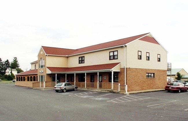
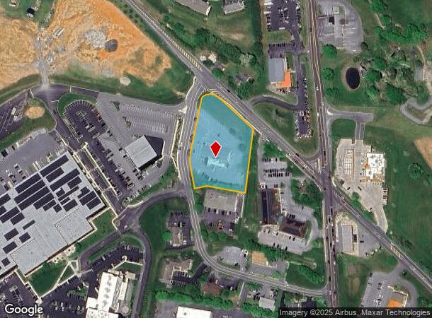
12 W Newport Rd
Lancaster, PA
Toll Gate North Ph 02
600-74551-0-0000
12 W NEWPORT RD
Restaurantbuilding
Lancaster
X
Pennsylvania
42071C0166F
1
2024
2.06 AC
2025
Lancaster County
012103
Philadelphia
12,438 SF
DEMOGRAPHICS near 12 W Newport Rd
1 Mile
3 Mile
5 Mile
2024 Total Population
4,107
27,069
62,497
2029 Population
4,139
27,230
63,190
Pop Growth 2024-2029
+ 0.78%
+ 0.59%
+ 1.11%
Average Age
43
44
44
2024 Total Households
1,567
10,802
23,806
HH Growth 2024-2029
+ 0.83%
+ 0.56%
+ 1.19%
Median Household Inc
$79,408
$81,879
$82,902
Avg Household Size
2.60
2.40
2.50
2024 Avg HH Vehicles
2.00
2.00
2.00
Median Home Value
$271,901
$272,725
$282,200
Median Year Built
1986
1981
1984
Nearby Places
Map Layers
Map Styles
 Street
 Aerial
- Restaurants
- Banks
- Shops
- Fitness
- Groceries
PUBLIC TRANSPORTATION
COMMUTER RAIL
DRIVE
WALK
Distance
17 min
9.0 mi
AIRPORT
Harrisburg International
DRIVE
WALK
Distance
Harrisburg International
47 min
33.2 mi
Freight Ports
Port Newark Container Terminal
DRIVE
WALK
Distance
Port Newark Container Terminal
95 min
56.8 mi
Nearby Properties
Address
Land Use
TOTAL SIZE
Lot Size
Zoning
Address
Land Use
TOTAL SIZE
Lot Size
Zoning
4,290 SF
35.80 AC
R-1
Address
Land Use
TOTAL SIZE
Lot Size
Zoning
1,196,914 SF
69.10 AC
I
Address
Land Use
TOTAL SIZE
Lot Size
Zoning
200,090 SF
Address
Land Use
TOTAL SIZE
Lot Size
Zoning
173,138 SF
36.20 AC
R-2
Address
Land Use
TOTAL SIZE
Lot Size
Zoning
213,584 SF
3.80 AC
CC
Address
Land Use
TOTAL SIZE
Lot Size
Zoning
148,187 SF
40 AC
R-1
Address
Land Use
TOTAL SIZE
Lot Size
Zoning
174,149 SF
0.22 AC
Address
Land Use
TOTAL SIZE
Lot Size
Zoning
210,312 SF
25.89 AC
R-2
Address
Land Use
TOTAL SIZE
Lot Size
Zoning
188,543 SF
26.76 AC
R-2
Address
Land Use
TOTAL SIZE
Lot Size
Zoning
89,662 SF
18.40 AC
R-1
Address
Land Use
TOTAL SIZE
Lot Size
Zoning
94,951 SF
26.80 AC
R-1
Address
Land Use
TOTAL SIZE
Lot Size
Zoning
257,486 SF
10.62 AC
Address
Land Use
TOTAL SIZE
Lot Size
Zoning
94,245 SF
111 AC
A
Address
Land Use
TOTAL SIZE
Lot Size
Zoning
111,061 SF
4.90 AC
Address
Land Use
TOTAL SIZE
Lot Size
Zoning
92,333 SF
3.34 AC
Address
Land Use
TOTAL SIZE
Lot Size
Zoning
88,535 SF
2.46 AC
R-2
Address
Land Use
TOTAL SIZE
Lot Size
Zoning
80,125 SF
19.27 AC
Address
Land Use
TOTAL SIZE
Lot Size
Zoning
112,382 SF
3.10 AC
I
Address
Land Use
TOTAL SIZE
Lot Size
Zoning
96,836 SF
11.47 AC
R-1
Address
Land Use
TOTAL SIZE
Lot Size
Zoning
109,519 SF
10.50 AC
R-2
Address
Land Use
TOTAL SIZE
Lot Size
Zoning
39,614 SF
4.10 AC
Address
Land Use
TOTAL SIZE
Lot Size
Zoning
129,558 SF
35.56 AC
R-1
Address
Land Use
TOTAL SIZE
Lot Size
Zoning
112,199 SF
6.20 AC
R-2
Address
Land Use
TOTAL SIZE
Lot Size
Zoning
48,960 SF
4.83 AC
Address
Land Use
TOTAL SIZE
Lot Size
Zoning
67,016 SF
1.90 AC
Address
Land Use
TOTAL SIZE
Lot Size
Zoning
173,052 SF
20.20 AC
I-1
Address
Land Use
TOTAL SIZE
Lot Size
Zoning
92,968 SF
12.90 AC
RA
Address
Land Use
TOTAL SIZE
Lot Size
Zoning
86,947 SF
6.30 AC
A
Address
Land Use
TOTAL SIZE
Lot Size
Zoning
50,480 SF
Address
Land Use
TOTAL SIZE
Lot Size
Zoning
56,982 SF
92.50 AC
A
The World's #1 Commercial Real Estate Marketplace
Connect with us
© 2025 CoStar Group
The information above has been obtained from sources believed reliable. While we do not doubt its accuracy we have not verified it and make no guarantee, warranty or representation about it. It is your responsibility to independently confirm its accuracy and completeness. Any projections, opinions, assumptions, or estimates used are for example only and do not represent the current or future performance of the property. The value of this transaction to you depends on tax and other factors which should be evaluated by your tax, financial, and legal advisors. You and your advisors should conduct a careful, independent investigation of the property to determine to your satisfaction the suitability of the property for your needs.