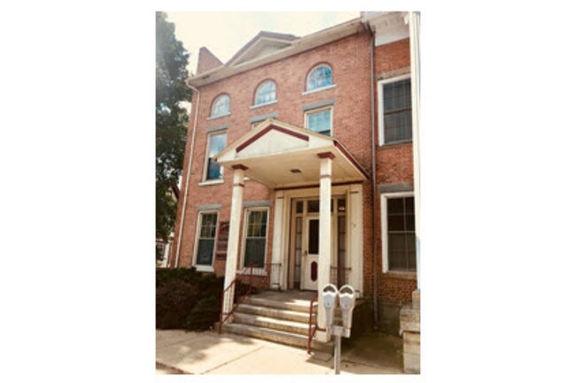
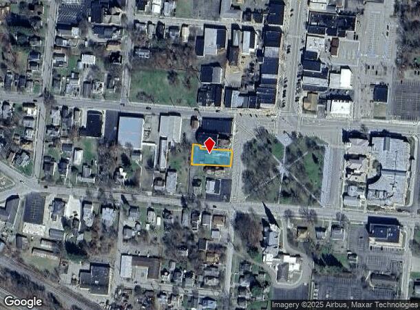
Property Record
12 W Pulteney Sq, Bath, NY 14810
NEARBY LISTINGS FOR SALE OR LEASE
Property Detail
12 W Pulteney Sq
Corning, NY
IRR 68.73X160.51 FT ASSES
462401-159-013-0004-013-000
Steuben
Commercialofficeresidentialmixeduse
New York
2025
13.000
2024
0.27 AC
961200
Ithaca/Elmira
4,150 SF
Other Market Areas
DEMOGRAPHICS near 12 W Pulteney Sq
1 Mile
3 Mile
5 Mile
2024 Total Population
4,669
7,790
9,826
2029 Population
4,569
7,625
9,622
Pop Growth 2024-2029
(2.14%)
(2.12%)
(2.08%)
Average Age
42
44
44
2024 Total Households
2,162
3,549
4,385
HH Growth 2024-2029
(2.13%)
(2.14%)
(2.08%)
Median Household Inc
$39,539
$41,014
$41,844
Avg Household Size
2.10
2.10
2.10
2024 Avg HH Vehicles
1.00
1.00
1.00
Median Home Value
$95,600
$105,215
$110,018
Median Year Built
1949
1960
1962
Nearby Places
- Restaurants
- Banks
- Shops
- Fitness
- Groceries
PUBLIC TRANSPORTATION
AIRPORT
Elmira/Corning Regional
DRIVE
WALK
Distance
Elmira/Corning Regional
44 min
33.5 mi
SALE & LEASE HISTORY
LISTING DATE
SALE/LEASE

Nov 26, 2018
For Sale
Nearby Properties
Address
Land Use
TOTAL SIZE
Lot Size
Zoning
Address
Land Use
TOTAL SIZE
Lot Size
Zoning
131,456 SF
215.80 AC
01 - NOT Z
Address
Land Use
TOTAL SIZE
Lot Size
Zoning
365,276 SF
54.90 AC
01 - NOT Z
Address
Land Use
TOTAL SIZE
Lot Size
Zoning
84,460 SF
3.83 AC
02 - SINGL
Address
Land Use
TOTAL SIZE
Lot Size
Zoning
171,741 SF
13.40 AC
01 - NOT Z
Address
Land Use
TOTAL SIZE
Lot Size
Zoning
168,338 SF
15 AC
02 - SINGL
Address
Land Use
TOTAL SIZE
Lot Size
Zoning
30,177 SF
0.79 AC
02 - SINGL
Address
Land Use
TOTAL SIZE
Lot Size
Zoning
62,443 SF
3.73 AC
01 - NOT Z
Address
Land Use
TOTAL SIZE
Lot Size
Zoning
1,536 SF
35.70 AC
02 - SINGL
Address
Land Use
TOTAL SIZE
Lot Size
Zoning
4,534 SF
146.20 AC
01 - NOT Z
Address
Land Use
TOTAL SIZE
Lot Size
Zoning
54,447 SF
5.97 AC
01 - NOT Z
Address
Land Use
TOTAL SIZE
Lot Size
Zoning
53,112 SF
5.58 AC
02 - SINGL
Address
Land Use
TOTAL SIZE
Lot Size
Zoning
14.03 AC
01 - NOT Z
Address
Land Use
TOTAL SIZE
Lot Size
Zoning
105,652 SF
2.42 AC
04 - FARM
Address
Land Use
TOTAL SIZE
Lot Size
Zoning
44,699 SF
5 AC
01 - NOT Z
Address
Land Use
TOTAL SIZE
Lot Size
Zoning
41,367 SF
9.64 AC
02 - SINGL
Address
Land Use
TOTAL SIZE
Lot Size
Zoning
12,024 SF
1.35 AC
04 - FARM
Address
Land Use
TOTAL SIZE
Lot Size
Zoning
15,594 SF
10.04 AC
01 - NOT Z
Address
Land Use
TOTAL SIZE
Lot Size
Zoning
5,904 SF
4 AC
02 - SINGL
Address
Land Use
TOTAL SIZE
Lot Size
Zoning
33.39 AC
01
Address
Land Use
TOTAL SIZE
Lot Size
Zoning
67,606 SF
6.75 AC
01 - NOT Z
Address
Land Use
TOTAL SIZE
Lot Size
Zoning
3,085 SF
214.07 AC
01 - NOT Z
Address
Land Use
TOTAL SIZE
Lot Size
Zoning
27,274 SF
1.62 AC
04 - FARM
Address
Land Use
TOTAL SIZE
Lot Size
Zoning
10,602 SF
3.97 AC
02 - SINGL
Address
Land Use
TOTAL SIZE
Lot Size
Zoning
11,472 SF
0.97 AC
04 - FARM
Address
Land Use
TOTAL SIZE
Lot Size
Zoning
59,387 SF
2.80 AC
04 - FARM
Address
Land Use
TOTAL SIZE
Lot Size
Zoning
924 SF
28.61 AC
01 - NOT Z
Address
Land Use
TOTAL SIZE
Lot Size
Zoning
16,315 SF
1.73 AC
02 - SINGL
Address
Land Use
TOTAL SIZE
Lot Size
Zoning
12,504 SF
1.77 AC
04 - FARM
Address
Land Use
TOTAL SIZE
Lot Size
Zoning
1,568 SF
18.44 AC
Address
Land Use
TOTAL SIZE
Lot Size
Zoning
16,968 SF
18.32 AC
04 - FARM
The World's #1 Commercial Real Estate Marketplace
Connect with us
© 2025 CoStar Group
The information above has been obtained from sources believed reliable. While we do not doubt its accuracy we have not verified it and make no guarantee, warranty or representation about it. It is your responsibility to independently confirm its accuracy and completeness. Any projections, opinions, assumptions, or estimates used are for example only and do not represent the current or future performance of the property. The value of this transaction to you depends on tax and other factors which should be evaluated by your tax, financial, and legal advisors. You and your advisors should conduct a careful, independent investigation of the property to determine to your satisfaction the suitability of the property for your needs.