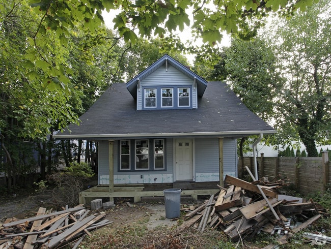
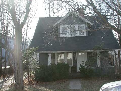
Property Record
12 Walnut St, Port Jefferson, NY 11777

NEARBY LISTINGS FOR SALE OR LEASE
Property Detail
12 Walnut St
Nassau County-Suffolk County, NY
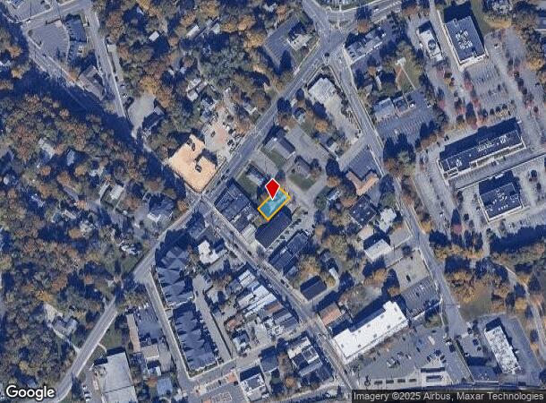
Map Of Land Located At Port Jefferson St
0207-021-00-05-00-014-000
Suffolk
Officebuilding
New York
X
14
36103C0395H
0.11 AC
2023
Central Suffolk
2024
Long Island (New York)
158206
DEMOGRAPHICS near 12 Walnut St
1 Mile
3 Mile
5 Mile
2024 Total Population
10,523
56,603
152,884
2029 Population
10,665
56,191
150,870
Pop Growth 2024-2029
+ 1.35%
(0.73%)
(1.32%)
Average Age
41
43
41
2024 Total Households
4,148
20,171
49,025
HH Growth 2024-2029
+ 1.16%
(0.93%)
(1.55%)
Median Household Inc
$108,891
$126,733
$122,120
Avg Household Size
2.40
2.70
2.80
2024 Avg HH Vehicles
2.00
2.00
2.00
Median Home Value
$549,402
$534,514
$475,708
Median Year Built
1979
1975
1973
Nearby Places
- Restaurants
- Banks
- Shops
- Fitness
- Groceries
PUBLIC TRANSPORTATION
COMMUTER RAIL
Port Jefferson Station (Port Jefferson Branch - Long Island Rail Road)
DRIVE
WALK
Distance
Port Jefferson Station (Port Jefferson Branch - Long Island Rail Road)
1 min
5 min
0.2 mi
Stony Brook Station (Port Jefferson Branch - Long Island Rail Road)
DRIVE
WALK
Distance
Stony Brook Station (Port Jefferson Branch - Long Island Rail Road)
13 min
6.8 mi
AIRPORT
Long Island MacArthur
DRIVE
WALK
Distance
Long Island MacArthur
28 min
16.4 mi
Tweed/New Haven
DRIVE
WALK
Distance
Tweed/New Haven
116 min
41.2 mi
Freight Ports
Port of New Haven
DRIVE
WALK
Distance
Port of New Haven
111 min
38.3 mi
Nearby Properties
Address
Land Use
TOTAL SIZE
Lot Size
Zoning
Address
Land Use
TOTAL SIZE
Lot Size
Zoning
31.31 AC
Address
Land Use
TOTAL SIZE
Lot Size
Zoning
6,522 SF
0.32 AC
VILLA
Address
Land Use
TOTAL SIZE
Lot Size
Zoning
41.35 AC
Address
Land Use
TOTAL SIZE
Lot Size
Zoning
1.22 AC
CR80
Address
Land Use
TOTAL SIZE
Lot Size
Zoning
0.92 AC
CR80
Address
Land Use
TOTAL SIZE
Lot Size
Zoning
3.52 AC
CR80
Address
Land Use
TOTAL SIZE
Lot Size
Zoning
23.75 AC
Address
Land Use
TOTAL SIZE
Lot Size
Zoning
Address
Land Use
TOTAL SIZE
Lot Size
Zoning
0.37 AC
R15
Address
Land Use
TOTAL SIZE
Lot Size
Zoning
13.70 AC
Address
Land Use
TOTAL SIZE
Lot Size
Zoning
28.20 AC
Address
Land Use
TOTAL SIZE
Lot Size
Zoning
Address
Land Use
TOTAL SIZE
Lot Size
Zoning
31.50 AC
Address
Land Use
TOTAL SIZE
Lot Size
Zoning
64.87 AC
Address
Land Use
TOTAL SIZE
Lot Size
Zoning
3,876 SF
0.17 AC
VILLA
Address
Land Use
TOTAL SIZE
Lot Size
Zoning
17.50 AC
Address
Land Use
TOTAL SIZE
Lot Size
Zoning
19.28 AC
Address
Land Use
TOTAL SIZE
Lot Size
Zoning
Address
Land Use
TOTAL SIZE
Lot Size
Zoning
17.81 AC
Address
Land Use
TOTAL SIZE
Lot Size
Zoning
49.83 AC
Address
Land Use
TOTAL SIZE
Lot Size
Zoning
Address
Land Use
TOTAL SIZE
Lot Size
Zoning
Address
Land Use
TOTAL SIZE
Lot Size
Zoning
Address
Land Use
TOTAL SIZE
Lot Size
Zoning
Address
Land Use
TOTAL SIZE
Lot Size
Zoning
0.54 AC
R20
Address
Land Use
TOTAL SIZE
Lot Size
Zoning
Address
Land Use
TOTAL SIZE
Lot Size
Zoning
Address
Land Use
TOTAL SIZE
Lot Size
Zoning
Address
Land Use
TOTAL SIZE
Lot Size
Zoning
Address
Land Use
TOTAL SIZE
Lot Size
Zoning
The World's #1 Commercial Real Estate Marketplace
Connect with us
© 2025 CoStar Group
The information above has been obtained from sources believed reliable. While we do not doubt its accuracy we have not verified it and make no guarantee, warranty or representation about it. It is your responsibility to independently confirm its accuracy and completeness. Any projections, opinions, assumptions, or estimates used are for example only and do not represent the current or future performance of the property. The value of this transaction to you depends on tax and other factors which should be evaluated by your tax, financial, and legal advisors. You and your advisors should conduct a careful, independent investigation of the property to determine to your satisfaction the suitability of the property for your needs.