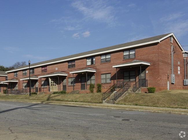
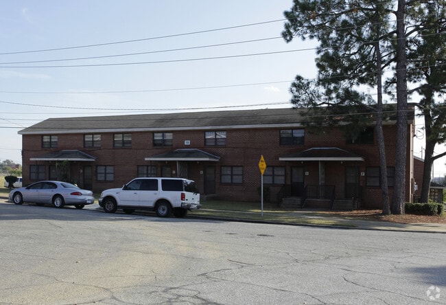
Property Record
120 20Th St, Columbus, GA 31901
NEARBY LISTINGS FOR SALE OR LEASE
Property Detail
120 20Th St
006-008-001
Housing Authority Of Col Ga
Governmentalpublicusegeneral
NORTH 42 44 WOOLFOLK TOWN L T CHASE HOMES NT
X
Muscogee
01113C0176C
Georgia
0
1.79 AC
2025
North Columbus
001600
Columbus GA
11,742 SF
Columbus, GA-AL
DEMOGRAPHICS near 120 20Th St
1 Mile
3 Mile
5 Mile
2024 Total Population
9,631
65,119
137,192
2029 Population
9,731
64,752
136,040
Pop Growth 2024-2029
+ 1.04%
(0.56%)
(0.84%)
Average Age
36
38
38
2024 Total Households
4,391
28,115
57,178
HH Growth 2024-2029
+ 1.18%
(0.56%)
(0.92%)
Median Household Inc
$26,323
$36,911
$42,023
Avg Household Size
2.10
2.20
2.30
2024 Avg HH Vehicles
1.00
1.00
2.00
Median Home Value
$80,083
$142,765
$156,609
Median Year Built
1960
1965
1971
Nearby Places
Map Layers
Map Styles
 Street
 Aerial
- Restaurants
- Banks
- Shops
- Fitness
- Groceries
PUBLIC TRANSPORTATION
AIRPORT
Columbus
DRIVE
WALK
Distance
Columbus
10 min
4.8 mi
Freight Ports
Port of Panama City
DRIVE
WALK
Distance
Port of Panama City
233 min
184.7 mi
Nearby Properties
Address
Land Use
TOTAL SIZE
Lot Size
Zoning
Address
Land Use
TOTAL SIZE
Lot Size
Zoning
81,423 SF
11.54 AC
Address
Land Use
TOTAL SIZE
Lot Size
Zoning
68,000 SF
11.21 AC
Address
Land Use
TOTAL SIZE
Lot Size
Zoning
2,744 SF
41.16 AC
Address
Land Use
TOTAL SIZE
Lot Size
Zoning
32,750 SF
4.01 AC
Address
Land Use
TOTAL SIZE
Lot Size
Zoning
2.48 AC
Address
Land Use
TOTAL SIZE
Lot Size
Zoning
43,888 SF
2 AC
Address
Land Use
TOTAL SIZE
Lot Size
Zoning
55,900 SF
27.05 AC
Address
Land Use
TOTAL SIZE
Lot Size
Zoning
216,360 SF
17.51 AC
Address
Land Use
TOTAL SIZE
Lot Size
Zoning
65,875 SF
2.37 AC
Address
Land Use
TOTAL SIZE
Lot Size
Zoning
63,220 SF
3.49 AC
Address
Land Use
TOTAL SIZE
Lot Size
Zoning
37,202 SF
8.03 AC
Address
Land Use
TOTAL SIZE
Lot Size
Zoning
56,095 SF
25.91 AC
Address
Land Use
TOTAL SIZE
Lot Size
Zoning
27,621 SF
6.33 AC
Address
Land Use
TOTAL SIZE
Lot Size
Zoning
2.31 AC
Address
Land Use
TOTAL SIZE
Lot Size
Zoning
32,238 SF
7.21 AC
Address
Land Use
TOTAL SIZE
Lot Size
Zoning
10,705 SF
0.64 AC
Address
Land Use
TOTAL SIZE
Lot Size
Zoning
64,793 SF
34.48 AC
Address
Land Use
TOTAL SIZE
Lot Size
Zoning
31,847 SF
1.21 AC
Address
Land Use
TOTAL SIZE
Lot Size
Zoning
4,334 SF
13.29 AC
Address
Land Use
TOTAL SIZE
Lot Size
Zoning
1.21 AC
Address
Land Use
TOTAL SIZE
Lot Size
Zoning
34,866 SF
2.34 AC
Address
Land Use
TOTAL SIZE
Lot Size
Zoning
18,050 SF
1.17 AC
Address
Land Use
TOTAL SIZE
Lot Size
Zoning
142,703 SF
28.48 AC
Address
Land Use
TOTAL SIZE
Lot Size
Zoning
29,640 SF
1.11 AC
Address
Land Use
TOTAL SIZE
Lot Size
Zoning
Address
Land Use
TOTAL SIZE
Lot Size
Zoning
Address
Land Use
TOTAL SIZE
Lot Size
Zoning
83,295 SF
17.87 AC
Address
Land Use
TOTAL SIZE
Lot Size
Zoning
78,948 SF
6 AC
Address
Land Use
TOTAL SIZE
Lot Size
Zoning
72,200 SF
5.52 AC
Address
Land Use
TOTAL SIZE
Lot Size
Zoning
2,870 SF
8.75 AC
The World's #1 Commercial Real Estate Marketplace
Connect with us
© 2026 CoStar Group
The information above has been obtained from sources believed reliable. While we do not doubt its accuracy we have not verified it and make no guarantee, warranty or representation about it. It is your responsibility to independently confirm its accuracy and completeness. Any projections, opinions, assumptions, or estimates used are for example only and do not represent the current or future performance of the property. The value of this transaction to you depends on tax and other factors which should be evaluated by your tax, financial, and legal advisors. You and your advisors should conduct a careful, independent investigation of the property to determine to your satisfaction the suitability of the property for your needs.