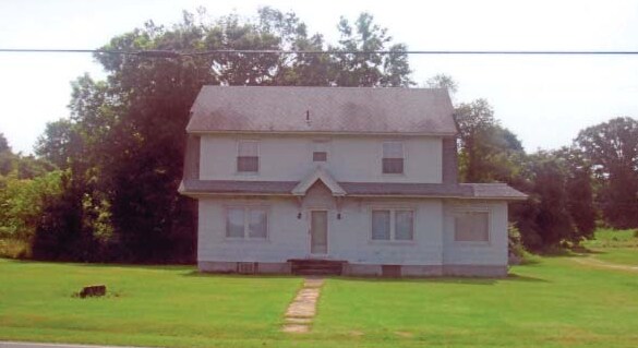
Property Record
120 Airpostate Route Rd, Green, NJ 07821

NEARBY LISTINGS FOR SALE OR LEASE
Property Detail
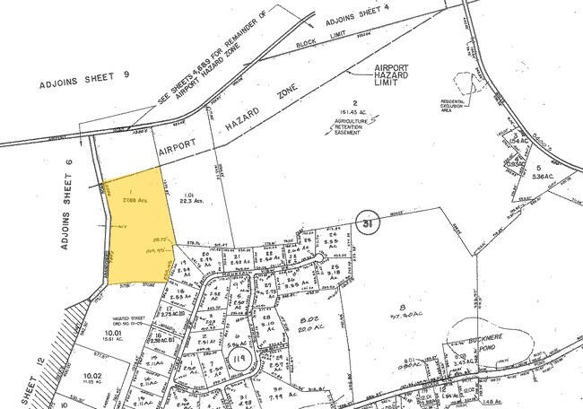
120 Airpostate Route Rd
08-00031-0000-00001-02
Sussex
Commercialnec
New Jersey
X
1.2
34037C0384E
9.25 AC
2024
Sussex County
2025
Northern New Jersey
374100
Newark, NJ-PA
1,832 SF
DEMOGRAPHICS near 120 Airpostate Route Rd
1 Mile
3 Mile
5 Mile
2024 Total Population
948
6,520
16,121
2029 Population
950
6,579
16,268
Pop Growth 2024-2029
+ 0.21%
+ 0.90%
+ 0.91%
Average Age
41
42
43
2024 Total Households
341
2,420
6,149
HH Growth 2024-2029
+ 0.29%
+ 1.07%
+ 1.02%
Median Household Inc
$126,704
$111,987
$111,478
Avg Household Size
2.80
2.70
2.60
2024 Avg HH Vehicles
2.00
2.00
2.00
Median Home Value
$371,100
$358,181
$344,856
Median Year Built
1975
1972
1973
Nearby Places
Map Layers
Map Styles
 Street
 Aerial
- Restaurants
- Banks
- Shops
- Fitness
- Groceries
PUBLIC TRANSPORTATION
COMMUTER RAIL
Mount Olive (Montclair-Boonton Line - NJ Transit Commuter Rail (NJ Transit), Morris & Essex Morristown Line - NJ Transit Commuter Rail (NJ Transit))
DRIVE
WALK
Distance
Mount Olive (Montclair-Boonton Line - NJ Transit Commuter Rail (NJ Transit), Morris & Essex Morristown Line - NJ Transit Commuter Rail (NJ Transit))
17 min
9.1 mi
Netcong (Montclair-Boonton Line - NJ Transit Commuter Rail (NJ Transit), Morris & Essex Morristown Line - NJ Transit Commuter Rail (NJ Transit))
DRIVE
WALK
Distance
Netcong (Montclair-Boonton Line - NJ Transit Commuter Rail (NJ Transit), Morris & Essex Morristown Line - NJ Transit Commuter Rail (NJ Transit))
17 min
9.6 mi
Freight Ports
Maher Terminal
DRIVE
WALK
Distance
Maher Terminal
65 min
49.9 mi
Nearby Properties
Address
Land Use
TOTAL SIZE
Lot Size
Zoning
Address
Land Use
TOTAL SIZE
Lot Size
Zoning
140,226 SF
12.78 AC
0001
Address
Land Use
TOTAL SIZE
Lot Size
Zoning
48 AC
0001
Address
Land Use
TOTAL SIZE
Lot Size
Zoning
11.24 AC
Address
Land Use
TOTAL SIZE
Lot Size
Zoning
24.63 AC
0001
Address
Land Use
TOTAL SIZE
Lot Size
Zoning
77,476 SF
9.81 AC
0006
Address
Land Use
TOTAL SIZE
Lot Size
Zoning
24,000 SF
12.32 AC
0006
Address
Land Use
TOTAL SIZE
Lot Size
Zoning
34,760 SF
10 AC
0006
Address
Land Use
TOTAL SIZE
Lot Size
Zoning
42,448 SF
11.84 AC
0006
Address
Land Use
TOTAL SIZE
Lot Size
Zoning
7.54 AC
0002
Address
Land Use
TOTAL SIZE
Lot Size
Zoning
2,080 SF
76 AC
C-R
Address
Land Use
TOTAL SIZE
Lot Size
Zoning
8.60 AC
NC
Address
Land Use
TOTAL SIZE
Lot Size
Zoning
121,008 SF
16.69 AC
I
Address
Land Use
TOTAL SIZE
Lot Size
Zoning
28,500 SF
10 AC
0006
Address
Land Use
TOTAL SIZE
Lot Size
Zoning
7.03 AC
0001
Address
Land Use
TOTAL SIZE
Lot Size
Zoning
408.10 AC
C-R
Address
Land Use
TOTAL SIZE
Lot Size
Zoning
3,008 SF
516.35 AC
Address
Land Use
TOTAL SIZE
Lot Size
Zoning
6.45 AC
AR52
Address
Land Use
TOTAL SIZE
Lot Size
Zoning
14,969 SF
2.57 AC
TCLM
Address
Land Use
TOTAL SIZE
Lot Size
Zoning
53,933 SF
2.35 AC
0003
Address
Land Use
TOTAL SIZE
Lot Size
Zoning
3,356 SF
21.80 AC
0001
Address
Land Use
TOTAL SIZE
Lot Size
Zoning
368 AC
OS
Address
Land Use
TOTAL SIZE
Lot Size
Zoning
358 AC
OS
Address
Land Use
TOTAL SIZE
Lot Size
Zoning
14,200 SF
3.34 AC
0003
Address
Land Use
TOTAL SIZE
Lot Size
Zoning
330 AC
OS
Address
Land Use
TOTAL SIZE
Lot Size
Zoning
161.19 AC
Address
Land Use
TOTAL SIZE
Lot Size
Zoning
5,660 SF
5 AC
0001
Address
Land Use
TOTAL SIZE
Lot Size
Zoning
6,782 SF
2 AC
0001
Address
Land Use
TOTAL SIZE
Lot Size
Zoning
1.35 AC
N-C
Address
Land Use
TOTAL SIZE
Lot Size
Zoning
11,760 SF
6.30 AC
0006
Address
Land Use
TOTAL SIZE
Lot Size
Zoning
3.10 AC
C1
The World's #1 Commercial Real Estate Marketplace
Connect with us
© 2025 CoStar Group
The information above has been obtained from sources believed reliable. While we do not doubt its accuracy we have not verified it and make no guarantee, warranty or representation about it. It is your responsibility to independently confirm its accuracy and completeness. Any projections, opinions, assumptions, or estimates used are for example only and do not represent the current or future performance of the property. The value of this transaction to you depends on tax and other factors which should be evaluated by your tax, financial, and legal advisors. You and your advisors should conduct a careful, independent investigation of the property to determine to your satisfaction the suitability of the property for your needs.