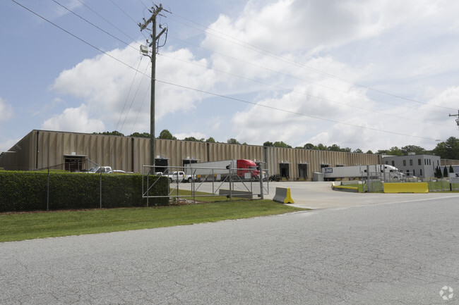
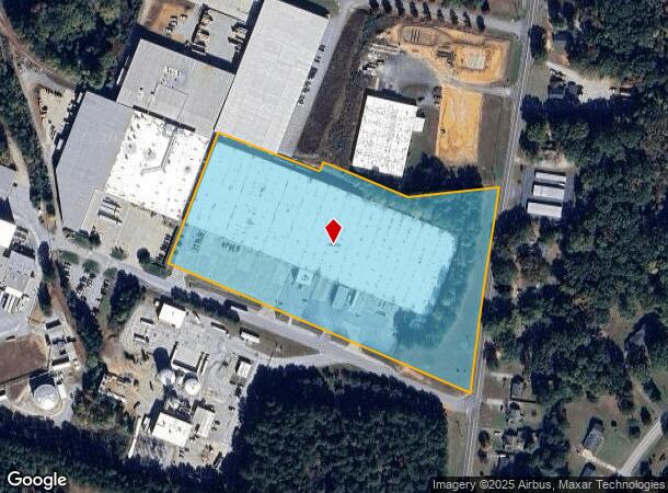
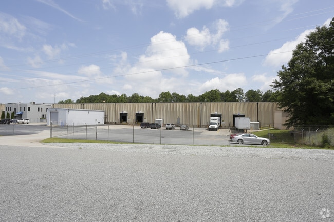
Property Record
120 Brooks Blvd, Spartanburg, SC 29307
NEARBY LISTINGS FOR SALE OR LEASE
Property Detail
120 Brooks Blvd
3-08-00-119.01
Omni Warehouses
Commercialnec
N SIDE BROOKS BLVD & W OF GOSSETT RD PB 181-59
X
Spartanburg
45021C0150D
South Carolina
0
9.59 AC
2025
Lower Spartanburg Cty
022201
Greenville/Spartanburg
201,008 SF
Spartanburg, SC
DEMOGRAPHICS near 120 Brooks Blvd
1 Mile
3 Mile
5 Mile
2024 Total Population
1,766
13,536
48,038
2029 Population
2,026
15,348
54,096
Pop Growth 2024-2029
+ 14.72%
+ 13.39%
+ 12.61%
Average Age
42
42
40
2024 Total Households
736
5,755
19,562
HH Growth 2024-2029
+ 14.81%
+ 13.68%
+ 13.13%
Median Household Inc
$55,861
$57,531
$60,227
Avg Household Size
2.30
2.20
2.30
2024 Avg HH Vehicles
2.00
2.00
2.00
Median Home Value
$135,022
$163,920
$182,616
Median Year Built
1984
1977
1977
Nearby Places
Map Layers
Map Styles
 Street
 Aerial
- Restaurants
- Banks
- Shops
- Fitness
- Groceries
PUBLIC TRANSPORTATION
COMMUTER RAIL
Spartanburg Amtrak Station (Crescent - Amtrak)
DRIVE
WALK
Distance
Spartanburg Amtrak Station (Crescent - Amtrak)
15 min
6.3 mi
AIRPORT
Greenville Spartanburg International
DRIVE
WALK
Distance
Greenville Spartanburg International
36 min
26.0 mi
Freight Ports
North Charleston Terminal
DRIVE
WALK
Distance
North Charleston Terminal
232 min
206.5 mi
SALE & LEASE HISTORY
LISTING DATE
SALE/LEASE

Sep 25, 2016
For Lease
Nearby Properties
Address
Land Use
TOTAL SIZE
Lot Size
Zoning
Address
Land Use
TOTAL SIZE
Lot Size
Zoning
5,672 SF
10.20 AC
Address
Land Use
TOTAL SIZE
Lot Size
Zoning
15,108 SF
16.27 AC
Address
Land Use
TOTAL SIZE
Lot Size
Zoning
18,600 SF
3.41 AC
Address
Land Use
TOTAL SIZE
Lot Size
Zoning
9,146 SF
51.62 AC
Address
Land Use
TOTAL SIZE
Lot Size
Zoning
6,798 SF
31.44 AC
Address
Land Use
TOTAL SIZE
Lot Size
Zoning
155,031 SF
12.58 AC
Address
Land Use
TOTAL SIZE
Lot Size
Zoning
16.45 AC
Address
Land Use
TOTAL SIZE
Lot Size
Zoning
214,026 SF
29.83 AC
Address
Land Use
TOTAL SIZE
Lot Size
Zoning
27,608 SF
17.61 AC
Address
Land Use
TOTAL SIZE
Lot Size
Zoning
7,570 SF
24.50 AC
Address
Land Use
TOTAL SIZE
Lot Size
Zoning
156,683 SF
11.23 AC
Address
Land Use
TOTAL SIZE
Lot Size
Zoning
26,086 SF
12.95 AC
Address
Land Use
TOTAL SIZE
Lot Size
Zoning
119,443 SF
13.64 AC
Address
Land Use
TOTAL SIZE
Lot Size
Zoning
522 SF
8.33 AC
Address
Land Use
TOTAL SIZE
Lot Size
Zoning
3,766 SF
0.23 AC
Address
Land Use
TOTAL SIZE
Lot Size
Zoning
1,300 SF
16.20 AC
Address
Land Use
TOTAL SIZE
Lot Size
Zoning
86,347 SF
39.12 AC
Address
Land Use
TOTAL SIZE
Lot Size
Zoning
209,070 SF
16.24 AC
Address
Land Use
TOTAL SIZE
Lot Size
Zoning
148,200 SF
7.46 AC
Address
Land Use
TOTAL SIZE
Lot Size
Zoning
5,661 SF
0.37 AC
Address
Land Use
TOTAL SIZE
Lot Size
Zoning
56,790 SF
2.59 AC
Address
Land Use
TOTAL SIZE
Lot Size
Zoning
4,123 SF
1.28 AC
Address
Land Use
TOTAL SIZE
Lot Size
Zoning
3,540 SF
1.09 AC
Address
Land Use
TOTAL SIZE
Lot Size
Zoning
2,748 SF
1.10 AC
Address
Land Use
TOTAL SIZE
Lot Size
Zoning
6,513 SF
1.76 AC
Address
Land Use
TOTAL SIZE
Lot Size
Zoning
650,000 SF
137.22 AC
Address
Land Use
TOTAL SIZE
Lot Size
Zoning
3,048 SF
0.59 AC
Address
Land Use
TOTAL SIZE
Lot Size
Zoning
1,800 SF
2.46 AC
Address
Land Use
TOTAL SIZE
Lot Size
Zoning
36,252 SF
4.15 AC
The World's #1 Commercial Real Estate Marketplace
Connect with us
© 2026 CoStar Group
The information above has been obtained from sources believed reliable. While we do not doubt its accuracy we have not verified it and make no guarantee, warranty or representation about it. It is your responsibility to independently confirm its accuracy and completeness. Any projections, opinions, assumptions, or estimates used are for example only and do not represent the current or future performance of the property. The value of this transaction to you depends on tax and other factors which should be evaluated by your tax, financial, and legal advisors. You and your advisors should conduct a careful, independent investigation of the property to determine to your satisfaction the suitability of the property for your needs.