Property Record
120 Cahaba Valley Pkwy, Pelham, AL 35124
NEARBY LISTINGS FOR SALE OR LEASE
Property Detail
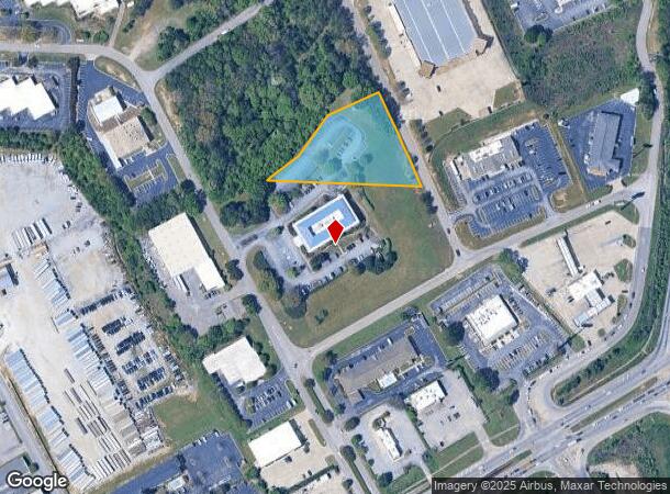
120 Cahaba Valley Pkwy
Birmingham-Hoover, AL
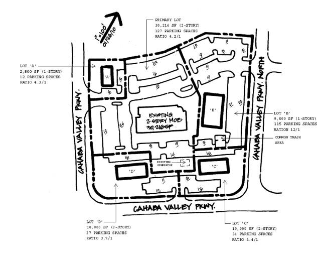
Golden Corrals Addn To Pelham Res
10-9-31-1-001-003-012
SEC/TWNSHP/RAN 31 19S 02W SEE ALSO 10 9 31 4 001 002 FOR REMAINDER OF LT 1B NBRHD: 08 PELHAM COMMERCIAL R-2
Medicalbuilding
Shelby
X
Alabama
01117C0208F
1b
2024
1.54 AC
2024
I-65 Corr/S Shelby County
030315
Birmingham
DEMOGRAPHICS near 120 Cahaba Valley Pkwy
1 Mile
3 Mile
5 Mile
2024 Total Population
2,900
32,776
83,334
2029 Population
3,302
34,833
86,222
Pop Growth 2024-2029
+ 13.86%
+ 6.28%
+ 3.47%
Average Age
37
40
40
2024 Total Households
1,041
13,619
33,706
HH Growth 2024-2029
+ 13.54%
+ 5.75%
+ 3.04%
Median Household Inc
$68,115
$72,013
$81,960
Avg Household Size
2.70
2.30
2.40
2024 Avg HH Vehicles
2.00
2.00
2.00
Median Home Value
$212,099
$273,561
$295,336
Median Year Built
1992
1991
1990
Nearby Places
- Restaurants
- Banks
- Shops
- Fitness
- Groceries
PUBLIC TRANSPORTATION
AIRPORT
Birmingham-Shuttlesworth International
DRIVE
WALK
Distance
Birmingham-Shuttlesworth International
29 min
20.2 mi
Freight Ports
Port of Mobile
DRIVE
WALK
Distance
Port of Mobile
263 min
242.0 mi
Nearby Properties
Address
Land Use
TOTAL SIZE
Lot Size
Zoning
Address
Land Use
TOTAL SIZE
Lot Size
Zoning
515,818 SF
38 AC
CP
Address
Land Use
TOTAL SIZE
Lot Size
Zoning
501,099 SF
33 AC
PO
Address
Land Use
TOTAL SIZE
Lot Size
Zoning
333,513 SF
40.80 AC
C2
Address
Land Use
TOTAL SIZE
Lot Size
Zoning
442,000 SF
36.44 AC
Address
Land Use
TOTAL SIZE
Lot Size
Zoning
267,122 SF
26 AC
PC
Address
Land Use
TOTAL SIZE
Lot Size
Zoning
12,200 SF
28.77 AC
Address
Land Use
TOTAL SIZE
Lot Size
Zoning
69,151 SF
4.90 AC
PC
Address
Land Use
TOTAL SIZE
Lot Size
Zoning
240,661 SF
53 AC
Address
Land Use
TOTAL SIZE
Lot Size
Zoning
210,033 SF
7.85 AC
Address
Land Use
TOTAL SIZE
Lot Size
Zoning
186,953 SF
20 AC
PR2
Address
Land Use
TOTAL SIZE
Lot Size
Zoning
2,199 SF
23 AC
Address
Land Use
TOTAL SIZE
Lot Size
Zoning
18,781 SF
12.09 AC
Address
Land Use
TOTAL SIZE
Lot Size
Zoning
241,232 SF
15.01 AC
PR2
Address
Land Use
TOTAL SIZE
Lot Size
Zoning
94,094 SF
14.40 AC
PO-P
Address
Land Use
TOTAL SIZE
Lot Size
Zoning
446,170 SF
18.93 AC
PR2
Address
Land Use
TOTAL SIZE
Lot Size
Zoning
165,474 SF
90 AC
PR2
Address
Land Use
TOTAL SIZE
Lot Size
Zoning
238,304 SF
18.90 AC
PR-2
Address
Land Use
TOTAL SIZE
Lot Size
Zoning
200,679 SF
20 AC
PR2
Address
Land Use
TOTAL SIZE
Lot Size
Zoning
176,949 SF
19 AC
PC
Address
Land Use
TOTAL SIZE
Lot Size
Zoning
2,792 SF
15 AC
Address
Land Use
TOTAL SIZE
Lot Size
Zoning
224,746 SF
46 AC
C2
Address
Land Use
TOTAL SIZE
Lot Size
Zoning
191,623 SF
19.93 AC
R4
Address
Land Use
TOTAL SIZE
Lot Size
Zoning
295,144 SF
22 AC
PR-2
Address
Land Use
TOTAL SIZE
Lot Size
Zoning
102,342 SF
11 AC
Address
Land Use
TOTAL SIZE
Lot Size
Zoning
20,680 SF
6.60 AC
Address
Land Use
TOTAL SIZE
Lot Size
Zoning
153,682 SF
20.07 AC
R4
Address
Land Use
TOTAL SIZE
Lot Size
Zoning
22,726 SF
15.77 AC
Address
Land Use
TOTAL SIZE
Lot Size
Zoning
230,053 SF
23 AC
Address
Land Use
TOTAL SIZE
Lot Size
Zoning
121,049 SF
9.10 AC
PR2
Address
Land Use
TOTAL SIZE
Lot Size
Zoning
30,123 SF
14.55 AC
The World's #1 Commercial Real Estate Marketplace
Connect with us
© 2025 CoStar Group
The information above has been obtained from sources believed reliable. While we do not doubt its accuracy we have not verified it and make no guarantee, warranty or representation about it. It is your responsibility to independently confirm its accuracy and completeness. Any projections, opinions, assumptions, or estimates used are for example only and do not represent the current or future performance of the property. The value of this transaction to you depends on tax and other factors which should be evaluated by your tax, financial, and legal advisors. You and your advisors should conduct a careful, independent investigation of the property to determine to your satisfaction the suitability of the property for your needs.