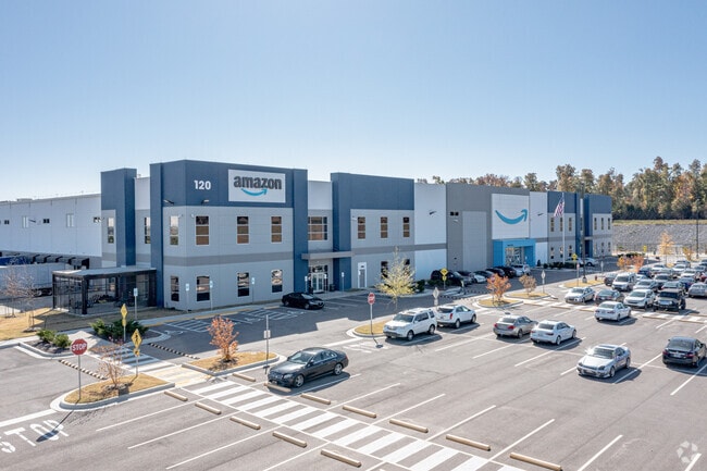
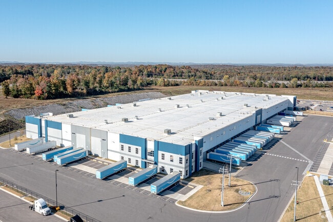
Property Record
120 Darrell Waltrip Dr, Lebanon, TN 37090

NEARBY LISTINGS FOR SALE OR LEASE
Property Detail
120 Darrell Waltrip Dr
Nashville-Davidson--Murfreesboro--Franklin, TN
Speedway Industrial Park Ph1
095158 00400
SPEEDWAY INDUSTRIAL PARK PH1 PB 30 PG 199 LOT 5 USE TO BE PARCEL 141 02604
Industrialgeneral
Wilson
X
Tennessee
47189C0190E
5
2024
38.30 AC
2024
Wilson County
030904
Nashville
253,816 SF
DEMOGRAPHICS near 120 Darrell Waltrip Dr
1 Mile
3 Mile
5 Mile
2024 Total Population
64
4,562
13,043
2029 Population
74
5,247
14,990
Pop Growth 2024-2029
+ 15.63%
+ 15.02%
+ 14.93%
Average Age
36
36
38
2024 Total Households
21
1,513
4,414
HH Growth 2024-2029
+ 14.29%
+ 14.74%
+ 14.59%
Median Household Inc
$97,916
$93,939
$92,190
Avg Household Size
3.00
3.00
2.90
2024 Avg HH Vehicles
3.00
2.00
3.00
Median Home Value
$299,999
$329,858
$357,518
Median Year Built
2005
2002
2001
Nearby Places
Map Layers
Map Styles
 Street
 Aerial
- Restaurants
- Banks
- Shops
- Fitness
- Groceries
PUBLIC TRANSPORTATION
AIRPORT
Nashville International
DRIVE
WALK
Distance
Nashville International
39 min
30.7 mi
Freight Ports
Port of Mobile
DRIVE
WALK
Distance
Port of Mobile
499 min
456.9 mi
SALE & LEASE HISTORY
LISTING DATE
SALE/LEASE

Jul 19, 2019
For Lease
Nearby Properties
Address
Land Use
TOTAL SIZE
Lot Size
Zoning
Address
Land Use
TOTAL SIZE
Lot Size
Zoning
518.06 AC
C4
Address
Land Use
TOTAL SIZE
Lot Size
Zoning
400,692 SF
43.22 AC
Address
Land Use
TOTAL SIZE
Lot Size
Zoning
975,387 SF
53.89 AC
Address
Land Use
TOTAL SIZE
Lot Size
Zoning
1,013,078 SF
62.49 AC
Address
Land Use
TOTAL SIZE
Lot Size
Zoning
1,012,648 SF
60.44 AC
Address
Land Use
TOTAL SIZE
Lot Size
Zoning
609,920 SF
46.72 AC
Address
Land Use
TOTAL SIZE
Lot Size
Zoning
609,737 SF
50.45 AC
Address
Land Use
TOTAL SIZE
Lot Size
Zoning
719,789 SF
58.56 AC
Address
Land Use
TOTAL SIZE
Lot Size
Zoning
709,800 SF
43.98 AC
C4
Address
Land Use
TOTAL SIZE
Lot Size
Zoning
442,852 SF
51.72 AC
Address
Land Use
TOTAL SIZE
Lot Size
Zoning
400,368 SF
58.05 AC
Address
Land Use
TOTAL SIZE
Lot Size
Zoning
598,974 SF
46.05 AC
C4
Address
Land Use
TOTAL SIZE
Lot Size
Zoning
616,322 SF
110.29 AC
Address
Land Use
TOTAL SIZE
Lot Size
Zoning
519,109 SF
98.31 AC
Address
Land Use
TOTAL SIZE
Lot Size
Zoning
552,946 SF
27.37 AC
C4
Address
Land Use
TOTAL SIZE
Lot Size
Zoning
576,300 SF
29.56 AC
C4
Address
Land Use
TOTAL SIZE
Lot Size
Zoning
442,540 SF
42.31 AC
Address
Land Use
TOTAL SIZE
Lot Size
Zoning
299,875 SF
26.71 AC
Address
Land Use
TOTAL SIZE
Lot Size
Zoning
436,799 SF
22.96 AC
Address
Land Use
TOTAL SIZE
Lot Size
Zoning
300,162 SF
37.45 AC
Address
Land Use
TOTAL SIZE
Lot Size
Zoning
258,720 SF
16.06 AC
C4
Address
Land Use
TOTAL SIZE
Lot Size
Zoning
252,112 SF
16.26 AC
Address
Land Use
TOTAL SIZE
Lot Size
Zoning
154,212 SF
19.02 AC
Address
Land Use
TOTAL SIZE
Lot Size
Zoning
705,723 SF
34.33 AC
C4
Address
Land Use
TOTAL SIZE
Lot Size
Zoning
90,000 SF
20 AC
C4
Address
Land Use
TOTAL SIZE
Lot Size
Zoning
29,004 SF
4.50 AC
C3
Address
Land Use
TOTAL SIZE
Lot Size
Zoning
80,336 SF
9.20 AC
C4
Address
Land Use
TOTAL SIZE
Lot Size
Zoning
44,800 SF
12.94 AC
Address
Land Use
TOTAL SIZE
Lot Size
Zoning
The World's #1 Commercial Real Estate Marketplace
Connect with us
© 2025 CoStar Group
The information above has been obtained from sources believed reliable. While we do not doubt its accuracy we have not verified it and make no guarantee, warranty or representation about it. It is your responsibility to independently confirm its accuracy and completeness. Any projections, opinions, assumptions, or estimates used are for example only and do not represent the current or future performance of the property. The value of this transaction to you depends on tax and other factors which should be evaluated by your tax, financial, and legal advisors. You and your advisors should conduct a careful, independent investigation of the property to determine to your satisfaction the suitability of the property for your needs.