Property Record
120 Dillard Rd, Madison Heights, VA 24572

NEARBY LISTINGS FOR SALE OR LEASE
Property Detail
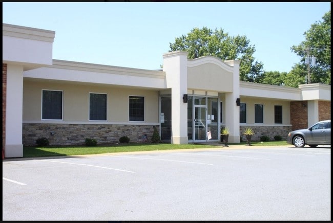
120 Dillard Rd
147-A-212
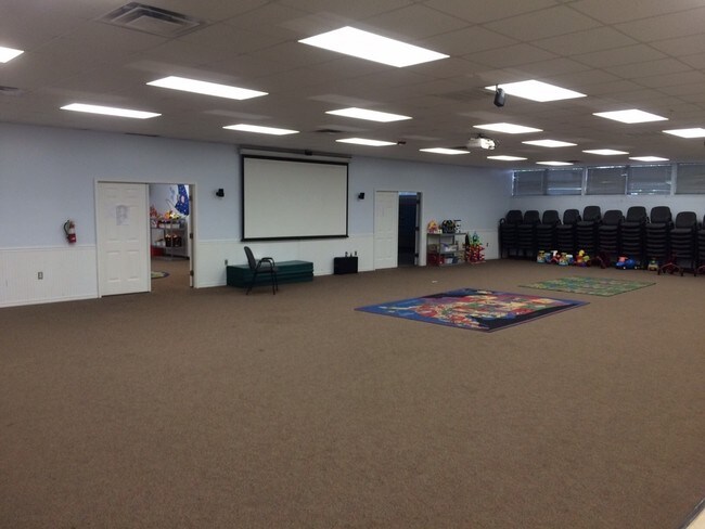
The Old Dominion Box
Officebuilding
ON RT 130 & RT 766 & RT 1324 120 DILLARD RD 147 A 212
X
Amherst
51009C0385C
Virginia
2024
7.66 AC
2025
Lynchburg
010506
Other Market Areas
8,979 SF
Lynchburg, VA
DEMOGRAPHICS near 120 Dillard Rd
1 Mile
3 Mile
5 Mile
2024 Total Population
1,042
20,166
51,235
2029 Population
1,060
20,513
51,724
Pop Growth 2024-2029
+ 1.73%
+ 1.72%
+ 0.95%
Average Age
41
40
38
2024 Total Households
446
8,828
21,034
HH Growth 2024-2029
+ 1.79%
+ 1.79%
+ 1.02%
Median Household Inc
$40,156
$47,831
$49,749
Avg Household Size
2.40
2.20
2.20
2024 Avg HH Vehicles
2.00
2.00
2.00
Median Home Value
$153,282
$155,240
$160,600
Median Year Built
1969
1963
1961
Nearby Places
Map Layers
Map Styles
 Street
 Aerial
- Restaurants
- Banks
- Shops
- Fitness
- Groceries
PUBLIC TRANSPORTATION
COMMUTER RAIL
Lynchburg (Crescent - Amtrak, Northeast Regional - Amtrak)
DRIVE
WALK
Distance
Lynchburg (Crescent - Amtrak, Northeast Regional - Amtrak)
10 min
6.8 mi
AIRPORT
Lynchburg Regional/Preston Glenn Field
DRIVE
WALK
Distance
Lynchburg Regional/Preston Glenn Field
22 min
14.1 mi
Freight Ports
Virginia Port Authority - Richmond
DRIVE
WALK
Distance
Virginia Port Authority - Richmond
154 min
112.3 mi
SALE & LEASE HISTORY
LISTING DATE
SALE/LEASE

Sep 24, 2016
For Sale
Jan 09, 2019
For Lease
Jan 09, 2019
For Sale
Nearby Properties
Address
Land Use
TOTAL SIZE
Lot Size
Zoning
Address
Land Use
TOTAL SIZE
Lot Size
Zoning
626,329 SF
50.88 AC
2521
Address
Land Use
TOTAL SIZE
Lot Size
Zoning
21,542 SF
41.78 AC
R2
Address
Land Use
TOTAL SIZE
Lot Size
Zoning
157,498 SF
11.25 AC
R3
Address
Land Use
TOTAL SIZE
Lot Size
Zoning
66,832 SF
48.77 AC
B2
Address
Land Use
TOTAL SIZE
Lot Size
Zoning
150,883 SF
7.41 AC
R4
Address
Land Use
TOTAL SIZE
Lot Size
Zoning
134,387 SF
12.17 AC
B2
Address
Land Use
TOTAL SIZE
Lot Size
Zoning
9.79 AC
B2
Address
Land Use
TOTAL SIZE
Lot Size
Zoning
61,415 SF
24.11 AC
P1
Address
Land Use
TOTAL SIZE
Lot Size
Zoning
154,922 SF
16.89 AC
B2
Address
Land Use
TOTAL SIZE
Lot Size
Zoning
128,488 SF
15.60 AC
B2
Address
Land Use
TOTAL SIZE
Lot Size
Zoning
56,400 SF
3.67 AC
R3
Address
Land Use
TOTAL SIZE
Lot Size
Zoning
37,488 SF
0.88 AC
B1
Address
Land Use
TOTAL SIZE
Lot Size
Zoning
30,537 SF
5.91 AC
B2
Address
Land Use
TOTAL SIZE
Lot Size
Zoning
76,170 SF
2.67 AC
R4
Address
Land Use
TOTAL SIZE
Lot Size
Zoning
149,422 SF
6.98 AC
M1
Address
Land Use
TOTAL SIZE
Lot Size
Zoning
56,122 SF
0.94 AC
R3
Address
Land Use
TOTAL SIZE
Lot Size
Zoning
57,851 SF
1.93 AC
I2
Address
Land Use
TOTAL SIZE
Lot Size
Zoning
42,481 SF
3.32 AC
R3
Address
Land Use
TOTAL SIZE
Lot Size
Zoning
37,146 SF
1.52 AC
R3
Address
Land Use
TOTAL SIZE
Lot Size
Zoning
60,545 SF
16.33 AC
B2
Address
Land Use
TOTAL SIZE
Lot Size
Zoning
40,395 SF
2.82 AC
P1
Address
Land Use
TOTAL SIZE
Lot Size
Zoning
23,793 SF
6.20 AC
B2
Address
Land Use
TOTAL SIZE
Lot Size
Zoning
100,000 SF
12.19 AC
M1
Address
Land Use
TOTAL SIZE
Lot Size
Zoning
18,666 SF
1.07 AC
B5
Address
Land Use
TOTAL SIZE
Lot Size
Zoning
34,155 SF
0.68 AC
R3
Address
Land Use
TOTAL SIZE
Lot Size
Zoning
111,468 SF
11.59 AC
M1
Address
Land Use
TOTAL SIZE
Lot Size
Zoning
19,786 SF
20 AC
R3
The World's #1 Commercial Real Estate Marketplace
Connect with us
© 2025 CoStar Group
The information above has been obtained from sources believed reliable. While we do not doubt its accuracy we have not verified it and make no guarantee, warranty or representation about it. It is your responsibility to independently confirm its accuracy and completeness. Any projections, opinions, assumptions, or estimates used are for example only and do not represent the current or future performance of the property. The value of this transaction to you depends on tax and other factors which should be evaluated by your tax, financial, and legal advisors. You and your advisors should conduct a careful, independent investigation of the property to determine to your satisfaction the suitability of the property for your needs.