Property Record
120 E 19Th St, Ottawa, KS 66067


Property Detail
120 E 19Th St
131-11-0-40-01-006.00-0
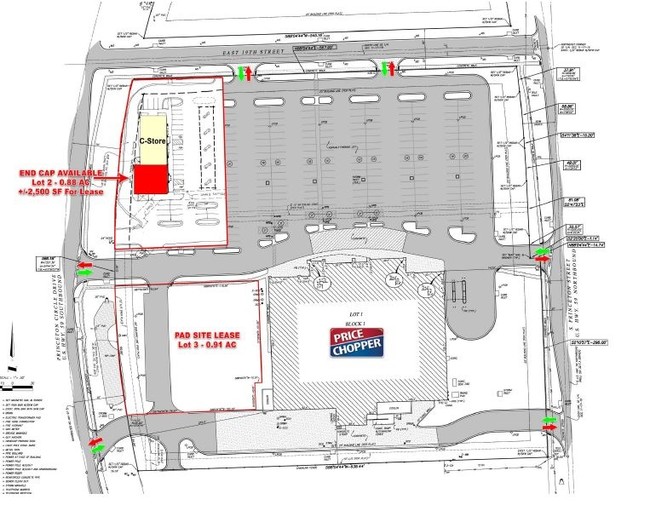
19TH & PRINCETON MARKET CENTER 2ND PLAT, S11, T17, R19E, ACRES 5.1, LT 1 BLK 1 EXC TR BEG NW/C LT 1 SLY284.6 E14.7 S164
Supermarket
Franklin
C2
Kansas
B and X Area of moderate flood hazard, usually the area between the limits of the 100-year and 500-year floods.
1,2
2024
5.18 AC
2025
Ottawa
954400
Kansas City
53,366 SF
Ottawa, KS
NEARBY LISTINGS FOR SALE OR LEASE
-
-
View all Ottawa listings for lease on LoopNet.com
DEMOGRAPHICS near 120 E 19Th St
1 mile
3 mile
5 mile
2025 Total Population
3,164
12,070
14,568
2030 Population
3,207
12,257
14,807
Pop Growth 2025-2030
+ 1.36%
+ 1.55%
+ 1.64%
Average Age
39
39
39
2025 Total Households
1,271
4,850
5,854
HH Growth 2025-2030
+ 1.49%
+ 1.63%
+ 1.69%
Median Household Inc
$55,987
$62,812
$64,515
Avg Household Size
2.30
2.40
2.40
2025 Avg HH Vehicles
2.00
2.00
2.00
Median Home Value
$188,905
$173,909
$172,010
Median Year Built
1975
1965
1969
Nearby Places
Map Layers
Map Styles
 Street
 Aerial
Layers
 Traffic
 Biking
Places
Listings with unknown addresses are not visible on the map
- Restaurants
- Banks
- Shops
- Fitness
- Groceries
SALE & LEASE HISTORY
LISTING DATE
SALE/LEASE

Jul 26, 2017
For Lease
Nearby Properties
Address
Land Use
TOTAL SIZE
Lot Size
Zoning
Address
Land Use
TOTAL SIZE
Lot Size
Zoning
115,413 SF
7.63 AC
O1
Address
Land Use
TOTAL SIZE
Lot Size
Zoning
35,262 SF
33.20 AC
R
Address
Land Use
TOTAL SIZE
Lot Size
Zoning
5,470 SF
39.70 AC
RS
Address
Land Use
TOTAL SIZE
Lot Size
Zoning
76,154 SF
13.90 AC
Address
Land Use
TOTAL SIZE
Lot Size
Zoning
52,556 SF
26.31 AC
C2
Address
Land Use
TOTAL SIZE
Lot Size
Zoning
79,735 SF
3.20 AC
C3
Address
Land Use
TOTAL SIZE
Lot Size
Zoning
50,753 SF
7.30 AC
R
Address
Land Use
TOTAL SIZE
Lot Size
Zoning
14,606 SF
5.04 AC
RS
Address
Land Use
TOTAL SIZE
Lot Size
Zoning
15,895 SF
1.06 AC
R1
Address
Land Use
TOTAL SIZE
Lot Size
Zoning
29,808 SF
10.30 AC
R
Address
Land Use
TOTAL SIZE
Lot Size
Zoning
49,756 SF
4.16 AC
C2
Address
Land Use
TOTAL SIZE
Lot Size
Zoning
20,441 SF
7.90 AC
Address
Land Use
TOTAL SIZE
Lot Size
Zoning
33,454 SF
1.36 AC
R2
Address
Land Use
TOTAL SIZE
Lot Size
Zoning
21,707 SF
1.12 AC
C3
Address
Land Use
TOTAL SIZE
Lot Size
Zoning
153.70 AC
A1
Address
Land Use
TOTAL SIZE
Lot Size
Zoning
152.10 AC
A1
Address
Land Use
TOTAL SIZE
Lot Size
Zoning
50,870 SF
3.96 AC
C2
Address
Land Use
TOTAL SIZE
Lot Size
Zoning
181,428 SF
29.33 AC
C2
Address
Land Use
TOTAL SIZE
Lot Size
Zoning
31,788 SF
1.55 AC
C3
Address
Land Use
TOTAL SIZE
Lot Size
Zoning
1.60 AC
Address
Land Use
TOTAL SIZE
Lot Size
Zoning
27,933 SF
0.69 AC
C3
Address
Land Use
TOTAL SIZE
Lot Size
Zoning
7,800 SF
21.65 AC
C2
Address
Land Use
TOTAL SIZE
Lot Size
Zoning
18,978 SF
2.17 AC
R
Address
Land Use
TOTAL SIZE
Lot Size
Zoning
4.76 AC
Address
Land Use
TOTAL SIZE
Lot Size
Zoning
24,478 SF
3.30 AC
R
Address
Land Use
TOTAL SIZE
Lot Size
Zoning
13,901 SF
0.95 AC
C1
Address
Land Use
TOTAL SIZE
Lot Size
Zoning
32.37 AC
R1
Address
Land Use
TOTAL SIZE
Lot Size
Zoning
60,370 SF
6.23 AC
C2
Address
Land Use
TOTAL SIZE
Lot Size
Zoning
15,000 SF
11.91 AC
RS
Address
Land Use
TOTAL SIZE
Lot Size
Zoning
12,000 SF
4.97 AC
RS
The World's #1 Commercial Real Estate Marketplace
Connect with us
© 2026 CoStar Group
The information above has been obtained from sources believed reliable. While we do not doubt its accuracy we have not verified it and make no guarantee, warranty or representation about it. It is your responsibility to independently confirm its accuracy and completeness. Any projections, opinions, assumptions, or estimates used are for example only and do not represent the current or future performance of the property. The value of this transaction to you depends on tax and other factors which should be evaluated by your tax, financial, and legal advisors. You and your advisors should conduct a careful, independent investigation of the property to determine to your satisfaction the suitability of the property for your needs.