Property Record
120 E Newark St, Ithaca, MI 48847
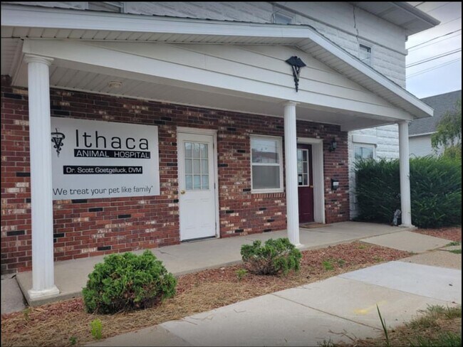
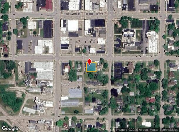
Property Detail
120 E Newark St
Alma, MI
Original Plat
52-010-159-00
WD L 513 P 337 ORIGINAL PLAT LOT 1 EX E 106 FT OF BLOCK 11.
Commercialnec
Gratiot
X
Michigan
26057C0200C
1
2023
0.17 AC
2025
Michigan North Central Area
001000
Other Market Areas
NEARBY LISTINGS FOR SALE OR LEASE
-
-
View all Ithaca listings for sale on LoopNet.com
DEMOGRAPHICS near 120 E Newark St
1 mile
3 mile
5 mile
2024 Total Population
2,895
3,746
5,177
2029 Population
2,873
3,695
5,075
Pop Growth 2024-2029
(0.76%)
(1.36%)
(1.97%)
Average Age
43
43
42
2024 Total Households
1,231
1,565
2,124
HH Growth 2024-2029
(0.89%)
(1.47%)
(2.07%)
Median Household Inc
$55,228
$56,012
$57,447
Avg Household Size
2.20
2.30
2.40
2024 Avg HH Vehicles
2.00
2.00
2.00
Median Home Value
$118,662
$126,779
$136,760
Median Year Built
1958
1957
1957
Nearby Places
Map Layers
Map Styles
 Street
 Aerial
Transit
 Traffic
 Biking
Places
Listings with unknown addresses are not visible on the map
- Restaurants
- Banks
- Shops
- Fitness
- Groceries
SALE & LEASE HISTORY
LISTING DATE
SALE/LEASE

Aug 14, 2023
For Sale
Nearby Properties
Address
Land Use
TOTAL SIZE
Lot Size
Zoning
Address
Land Use
TOTAL SIZE
Lot Size
Zoning
232.53 AC
Address
Land Use
TOTAL SIZE
Lot Size
Zoning
218.75 AC
Address
Land Use
TOTAL SIZE
Lot Size
Zoning
208.75 AC
Address
Land Use
TOTAL SIZE
Lot Size
Zoning
Address
Land Use
TOTAL SIZE
Lot Size
Zoning
Address
Land Use
TOTAL SIZE
Lot Size
Zoning
177.92 AC
Address
Land Use
TOTAL SIZE
Lot Size
Zoning
Address
Land Use
TOTAL SIZE
Lot Size
Zoning
135.51 AC
Address
Land Use
TOTAL SIZE
Lot Size
Zoning
155.96 AC
Address
Land Use
TOTAL SIZE
Lot Size
Zoning
4.08 AC
Address
Land Use
TOTAL SIZE
Lot Size
Zoning
21.65 AC
Address
Land Use
TOTAL SIZE
Lot Size
Zoning
158.90 AC
Address
Land Use
TOTAL SIZE
Lot Size
Zoning
Address
Land Use
TOTAL SIZE
Lot Size
Zoning
3.96 AC
Address
Land Use
TOTAL SIZE
Lot Size
Zoning
155.54 AC
Address
Land Use
TOTAL SIZE
Lot Size
Zoning
2.38 AC
Address
Land Use
TOTAL SIZE
Lot Size
Zoning
99.30 AC
Address
Land Use
TOTAL SIZE
Lot Size
Zoning
118.76 AC
Address
Land Use
TOTAL SIZE
Lot Size
Zoning
3.43 AC
Address
Land Use
TOTAL SIZE
Lot Size
Zoning
96.50 AC
Address
Land Use
TOTAL SIZE
Lot Size
Zoning
163 AC
Address
Land Use
TOTAL SIZE
Lot Size
Zoning
Address
Land Use
TOTAL SIZE
Lot Size
Zoning
160 AC
Address
Land Use
TOTAL SIZE
Lot Size
Zoning
153.70 AC
Address
Land Use
TOTAL SIZE
Lot Size
Zoning
140 AC
Address
Land Use
TOTAL SIZE
Lot Size
Zoning
136.54 AC
Address
Land Use
TOTAL SIZE
Lot Size
Zoning
118 AC
Address
Land Use
TOTAL SIZE
Lot Size
Zoning
Address
Land Use
TOTAL SIZE
Lot Size
Zoning
2.26 AC
Address
Land Use
TOTAL SIZE
Lot Size
Zoning
The World's #1 Commercial Real Estate Marketplace
Connect with us
© 2026 CoStar Group
The information above has been obtained from sources believed reliable. While we do not doubt its accuracy we have not verified it and make no guarantee, warranty or representation about it. It is your responsibility to independently confirm its accuracy and completeness. Any projections, opinions, assumptions, or estimates used are for example only and do not represent the current or future performance of the property. The value of this transaction to you depends on tax and other factors which should be evaluated by your tax, financial, and legal advisors. You and your advisors should conduct a careful, independent investigation of the property to determine to your satisfaction the suitability of the property for your needs.