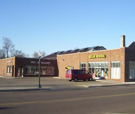
Property Record
120 E Prairie St, Vicksburg, MI 49097
Save to a Folder
{{folder.Name}}
{{folder.ListingIds.length}} Properties
{{folder.ListingIds.length}} Property
Create a New Folder
Property Detail
120 E Prairie St
14-13-442-040
P 37-40,-41,&-42 VILLAGE OF VICKSBURG ORIGINAL PLAT LO TS 4 AND 5 * BLK 5* **1985 ASMT BASE 60,800
Commercialnec
Kalamazoo
B and X Area of moderate flood hazard, usually the area between the limits of the 100-year and 500-year floods.
Michigan
2025
0.30 AC
2025
Southern Kalamazoo County
006103
West Michigan
10,992 SF
Kalamazoo-Portage, MI
NEARBY LISTINGS FOR SALE OR LEASE
-
-
View all Vicksburg listings for sale on LoopNet.com
DEMOGRAPHICS near 120 E Prairie St
1 mile
3 mile
5 mile
2025 Total Population
2,436
7,909
20,852
2030 Population
2,435
7,950
20,918
Pop Growth 2025-2030
(0.04%)
+ 0.52%
+ 0.32%
Average Age
40
40
42
2025 Total Households
943
3,020
8,135
HH Growth 2025-2030
(0.21%)
+ 0.36%
+ 0.18%
Median Household Inc
$71,249
$81,612
$90,330
Avg Household Size
2.60
2.60
2.50
2025 Avg HH Vehicles
2.00
2.00
2.00
Median Home Value
$240,724
$269,100
$292,363
Median Year Built
1968
1974
1976
Nearby Places
Map Layers
Map Styles
 Street
 Aerial
Layers
 Traffic
 Biking
Places
Listings with unknown addresses are not visible on the map
- Restaurants
- Banks
- Shops
- Fitness
- Groceries
PUBLIC TRANSPORTATION
AIRPORT
Kalamazoo/Battle Creek International
Drive
Walk
Distance
Kalamazoo/Battle Creek International
24 min
10.7 mi
SALE & LEASE HISTORY
LISTING DATE
SALE/LEASE

Sep 24, 2016
For Sale
Jul 27, 2017
For Sale
Nearby Properties
Address
Land Use
TOTAL SIZE
Lot Size
Zoning
Address
Land Use
TOTAL SIZE
Lot Size
Zoning
94,031 SF
15.42 AC
Address
Land Use
TOTAL SIZE
Lot Size
Zoning
149,625 SF
10.05 AC
Address
Land Use
TOTAL SIZE
Lot Size
Zoning
59,616 SF
Address
Land Use
TOTAL SIZE
Lot Size
Zoning
Address
Land Use
TOTAL SIZE
Lot Size
Zoning
281,066 SF
21.36 AC
Address
Land Use
TOTAL SIZE
Lot Size
Zoning
40,040 SF
5.84 AC
Address
Land Use
TOTAL SIZE
Lot Size
Zoning
110,014 SF
4.06 AC
Address
Land Use
TOTAL SIZE
Lot Size
Zoning
456.80 AC
MIXED
Address
Land Use
TOTAL SIZE
Lot Size
Zoning
990 SF
293.71 AC
Address
Land Use
TOTAL SIZE
Lot Size
Zoning
55,000 SF
Address
Land Use
TOTAL SIZE
Lot Size
Zoning
29,820 SF
10.62 AC
Address
Land Use
TOTAL SIZE
Lot Size
Zoning
31,200 SF
Address
Land Use
TOTAL SIZE
Lot Size
Zoning
19,640 SF
9.06 AC
Address
Land Use
TOTAL SIZE
Lot Size
Zoning
96.41 AC
AG
Address
Land Use
TOTAL SIZE
Lot Size
Zoning
576 SF
1.13 AC
SCHTWP.ORG
Address
Land Use
TOTAL SIZE
Lot Size
Zoning
2,996 SF
124 AC
Address
Land Use
TOTAL SIZE
Lot Size
Zoning
25,864 SF
4.45 AC
Address
Land Use
TOTAL SIZE
Lot Size
Zoning
25,200 SF
5 AC
VILLAGE
Address
Land Use
TOTAL SIZE
Lot Size
Zoning
22,724 SF
5.50 AC
Address
Land Use
TOTAL SIZE
Lot Size
Zoning
3,144 SF
80 AC
Address
Land Use
TOTAL SIZE
Lot Size
Zoning
15,128 SF
2.10 AC
Address
Land Use
TOTAL SIZE
Lot Size
Zoning
14,032 SF
13.72 AC
Address
Land Use
TOTAL SIZE
Lot Size
Zoning
2,195 SF
158.30 AC
AG
Address
Land Use
TOTAL SIZE
Lot Size
Zoning
9,829 SF
0.31 AC
Address
Land Use
TOTAL SIZE
Lot Size
Zoning
3,344 SF
76.20 AC
AG
Address
Land Use
TOTAL SIZE
Lot Size
Zoning
23,997 SF
1.95 AC
Address
Land Use
TOTAL SIZE
Lot Size
Zoning
17,293 SF
2.44 AC
Address
Land Use
TOTAL SIZE
Lot Size
Zoning
Address
Land Use
TOTAL SIZE
Lot Size
Zoning
24,150 SF
1.86 AC
Address
Land Use
TOTAL SIZE
Lot Size
Zoning
142.85 AC
SCHTWP.ORG
The World's #1 Commercial Real Estate Marketplace
Connect with us
© 2026 CoStar Group
The information above has been obtained from sources believed reliable. While we do not doubt its accuracy we have not verified it and make no guarantee, warranty or representation about it. It is your responsibility to independently confirm its accuracy and completeness. Any projections, opinions, assumptions, or estimates used are for example only and do not represent the current or future performance of the property. The value of this transaction to you depends on tax and other factors which should be evaluated by your tax, financial, and legal advisors. You and your advisors should conduct a careful, independent investigation of the property to determine to your satisfaction the suitability of the property for your needs.