Property Record
120 E St, Belle Chasse, LA 70037
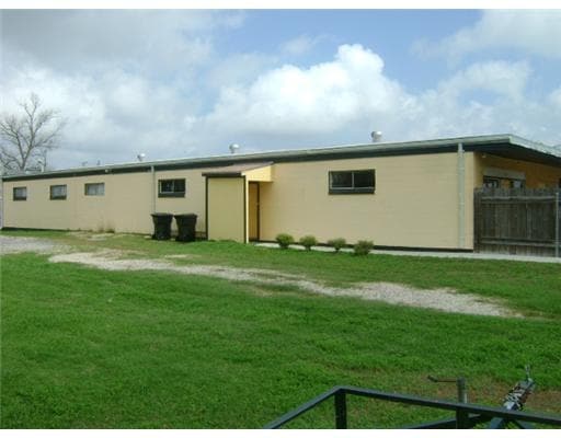

This Property Is For Sale
Property Detail
120 E St
New Orleans-Metairie, LA
LOTS 23 & 24, SQ F, HODGE HUNT HERO S/D - 50' FRONT X 145'. NURSERY SCHOOL
1400925
Plaquemines
Commercialnec
Louisiana
RM1
23-24
2024
0.17 AC
2024
Plaquemines Parish
050202
New Orleans/Metairie/Kenner
5,488 SF
NEARBY LISTINGS FOR SALE OR LEASE
DEMOGRAPHICS near 120 E St
1 mile
3 mile
5 mile
2025 Total Population
5,743
41,825
118,431
2030 Population
5,387
40,293
114,693
Pop Growth 2025-2030
(6.20%)
(3.66%)
(3.16%)
Average Age
39
39
39
2025 Total Households
2,040
15,005
43,920
HH Growth 2025-2030
(6.47%)
(3.89%)
(3.37%)
Median Household Inc
$107,342
$73,427
$57,558
Avg Household Size
2.80
2.70
2.60
2025 Avg HH Vehicles
2.00
2.00
2.00
Median Home Value
$415,983
$272,197
$240,078
Median Year Built
1987
1982
1977
Nearby Places
Map Layers
Map Styles
 Street
 Aerial
Transit
 Traffic
 Biking
Places
Listings with unknown addresses are not visible on the map
- Restaurants
- Banks
- Shops
- Fitness
- Groceries
PUBLIC TRANSPORTATION
COMMUTER RAIL
New Orleans Union Passenger Terminal (City of New Orleans - Amtrak, Crescent - Amtrak, Sunset Limited - Amtrak)
Drive
Walk
Distance
New Orleans Union Passenger Terminal (City of New Orleans - Amtrak, Crescent - Amtrak, Sunset Limited - Amtrak)
17 min
9.6 mi
AIRPORT
Louis Armstrong New Orleans International
Drive
Walk
Distance
Louis Armstrong New Orleans International
36 min
24.0 mi
Freight Ports
Plaquemines Port
Drive
Walk
Distance
Plaquemines Port
1 min
0.8 mi
Nearby Properties
Address
Land Use
TOTAL SIZE
Lot Size
Zoning
Address
Land Use
TOTAL SIZE
Lot Size
Zoning
3,215.52 AC
Address
Land Use
TOTAL SIZE
Lot Size
Zoning
14.40 AC
Address
Land Use
TOTAL SIZE
Lot Size
Zoning
Address
Land Use
TOTAL SIZE
Lot Size
Zoning
16.87 AC
R1A
Address
Land Use
TOTAL SIZE
Lot Size
Zoning
Address
Land Use
TOTAL SIZE
Lot Size
Zoning
Address
Land Use
TOTAL SIZE
Lot Size
Zoning
12.33 AC
Address
Land Use
TOTAL SIZE
Lot Size
Zoning
2,160 SF
267.42 AC
A1
Address
Land Use
TOTAL SIZE
Lot Size
Zoning
Address
Land Use
TOTAL SIZE
Lot Size
Zoning
30.04 AC
A1
Address
Land Use
TOTAL SIZE
Lot Size
Zoning
387 AC
Address
Land Use
TOTAL SIZE
Lot Size
Zoning
Address
Land Use
TOTAL SIZE
Lot Size
Zoning
45,000 SF
Address
Land Use
TOTAL SIZE
Lot Size
Zoning
574,842 SF
53.74 AC
S-RM1
Address
Land Use
TOTAL SIZE
Lot Size
Zoning
0.08 AC
Address
Land Use
TOTAL SIZE
Lot Size
Zoning
11.62 AC
Address
Land Use
TOTAL SIZE
Lot Size
Zoning
9.39 AC
R1A
Address
Land Use
TOTAL SIZE
Lot Size
Zoning
7,200 SF
1.46 AC
C2
Address
Land Use
TOTAL SIZE
Lot Size
Zoning
9.15 AC
R1A
Address
Land Use
TOTAL SIZE
Lot Size
Zoning
5.35 AC
H1
Address
Land Use
TOTAL SIZE
Lot Size
Zoning
260,452 SF
11.03 AC
S-RM1
Address
Land Use
TOTAL SIZE
Lot Size
Zoning
148,122 SF
46.58 AC
I3
Address
Land Use
TOTAL SIZE
Lot Size
Zoning
4.01 AC
C2
Address
Land Use
TOTAL SIZE
Lot Size
Zoning
5.73 AC
MUCD
Address
Land Use
TOTAL SIZE
Lot Size
Zoning
Address
Land Use
TOTAL SIZE
Lot Size
Zoning
10.88 AC
Address
Land Use
TOTAL SIZE
Lot Size
Zoning
6.41 AC
Address
Land Use
TOTAL SIZE
Lot Size
Zoning
7.76 AC
R1A
Address
Land Use
TOTAL SIZE
Lot Size
Zoning
4,181 AC
Address
Land Use
TOTAL SIZE
Lot Size
Zoning
160.89 AC
The World's #1 Commercial Real Estate Marketplace
Connect with us
© 2026 CoStar Group
The information above has been obtained from sources believed reliable. While we do not doubt its accuracy we have not verified it and make no guarantee, warranty or representation about it. It is your responsibility to independently confirm its accuracy and completeness. Any projections, opinions, assumptions, or estimates used are for example only and do not represent the current or future performance of the property. The value of this transaction to you depends on tax and other factors which should be evaluated by your tax, financial, and legal advisors. You and your advisors should conduct a careful, independent investigation of the property to determine to your satisfaction the suitability of the property for your needs.