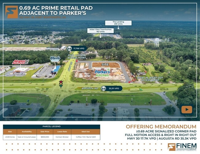
Property Record
120 Ga Highway 30, Port Wentworth, GA 31407

Current Lease Availabilities
NEARBY LISTINGS FOR SALE OR LEASE
Property Detail
120 Ga Highway 30
7097602003
West Side 1
Vacantlandnec
PARCEL A, FLOYD PROPERTY, 8TH GM D, PT WENTWORTH
X
Chatham
45053C0475D
Georgia
2024
4.33 AC
2025
Port Wentworth
010702
Savannah
1,170 SF
Savannah, GA
DEMOGRAPHICS near 120 Ga Highway 30
1 Mile
3 Mile
5 Mile
2024 Total Population
3,817
17,438
39,507
2029 Population
4,064
18,484
42,343
Pop Growth 2024-2029
+ 6.47%
+ 6.00%
+ 7.18%
Average Age
34
35
36
2024 Total Households
1,467
6,150
14,374
HH Growth 2024-2029
+ 6.82%
+ 6.50%
+ 7.36%
Median Household Inc
$83,486
$85,334
$88,978
Avg Household Size
2.60
2.50
2.60
2024 Avg HH Vehicles
2.00
2.00
2.00
Median Home Value
$277,196
$271,265
$286,887
Median Year Built
2007
2010
2008
Nearby Places
- Restaurants
- Banks
- Shops
- Fitness
- Groceries
PUBLIC TRANSPORTATION
AIRPORT
Savannah/Hilton Head International
DRIVE
WALK
Distance
Savannah/Hilton Head International
17 min
8.9 mi
Hilton Head
DRIVE
WALK
Distance
Hilton Head
49 min
37.5 mi
Freight Ports
Georgia Ports - Savannah
DRIVE
WALK
Distance
Georgia Ports - Savannah
12 min
7.2 mi
Nearby Properties
Address
Land Use
TOTAL SIZE
Lot Size
Zoning
Address
Land Use
TOTAL SIZE
Lot Size
Zoning
1,008 SF
150 AC
I-H
Address
Land Use
TOTAL SIZE
Lot Size
Zoning
1,400,224 SF
325.62 AC
I-H
Address
Land Use
TOTAL SIZE
Lot Size
Zoning
1,275,180 SF
0.02 AC
Address
Land Use
TOTAL SIZE
Lot Size
Zoning
1,164,800 SF
86.22 AC
Address
Land Use
TOTAL SIZE
Lot Size
Zoning
1,500,400 SF
207.84 AC
PD
Address
Land Use
TOTAL SIZE
Lot Size
Zoning
1,099,220 SF
206.18 AC
I-H
Address
Land Use
TOTAL SIZE
Lot Size
Zoning
1,003,267 SF
64.07 AC
I-H
Address
Land Use
TOTAL SIZE
Lot Size
Zoning
981,943 SF
69.54 AC
I-H
Address
Land Use
TOTAL SIZE
Lot Size
Zoning
1,210,040 SF
93.21 AC
PD
Address
Land Use
TOTAL SIZE
Lot Size
Zoning
1,164,800 SF
73.57 AC
PD
Address
Land Use
TOTAL SIZE
Lot Size
Zoning
832,000 SF
59.75 AC
I-H
Address
Land Use
TOTAL SIZE
Lot Size
Zoning
1,067,040 SF
77.66 AC
PD
Address
Land Use
TOTAL SIZE
Lot Size
Zoning
800,100 SF
44.51 AC
I-H
Address
Land Use
TOTAL SIZE
Lot Size
Zoning
750,480 SF
52.93 AC
IH
Address
Land Use
TOTAL SIZE
Lot Size
Zoning
737,500 SF
49.38 AC
I-1
Address
Land Use
TOTAL SIZE
Lot Size
Zoning
Address
Land Use
TOTAL SIZE
Lot Size
Zoning
28,128 SF
31.61 AC
RA
Address
Land Use
TOTAL SIZE
Lot Size
Zoning
70,000 SF
71.90 AC
IH
Address
Land Use
TOTAL SIZE
Lot Size
Zoning
752,000 SF
51.18 AC
Address
Land Use
TOTAL SIZE
Lot Size
Zoning
24,648 SF
23.38 AC
Address
Land Use
TOTAL SIZE
Lot Size
Zoning
27,420 SF
34.55 AC
R1
Address
Land Use
TOTAL SIZE
Lot Size
Zoning
631,800 SF
38.47 AC
Address
Land Use
TOTAL SIZE
Lot Size
Zoning
777,150 SF
92.46 AC
PD
Address
Land Use
TOTAL SIZE
Lot Size
Zoning
2,000 SF
24.74 AC
PUDCC
Address
Land Use
TOTAL SIZE
Lot Size
Zoning
2,156 SF
36.64 AC
PIL
Address
Land Use
TOTAL SIZE
Lot Size
Zoning
10,600 SF
21.93 AC
PUD
Address
Land Use
TOTAL SIZE
Lot Size
Zoning
23,946 SF
22.68 AC
PUDC
Address
Land Use
TOTAL SIZE
Lot Size
Zoning
579,000 SF
33.93 AC
I-H
Address
Land Use
TOTAL SIZE
Lot Size
Zoning
499,200 SF
33.02 AC
PUDC
Address
Land Use
TOTAL SIZE
Lot Size
Zoning
600,000 SF
62.25 AC
I-H
The World's #1 Commercial Real Estate Marketplace
Connect with us
© 2025 CoStar Group
The information above has been obtained from sources believed reliable. While we do not doubt its accuracy we have not verified it and make no guarantee, warranty or representation about it. It is your responsibility to independently confirm its accuracy and completeness. Any projections, opinions, assumptions, or estimates used are for example only and do not represent the current or future performance of the property. The value of this transaction to you depends on tax and other factors which should be evaluated by your tax, financial, and legal advisors. You and your advisors should conduct a careful, independent investigation of the property to determine to your satisfaction the suitability of the property for your needs.