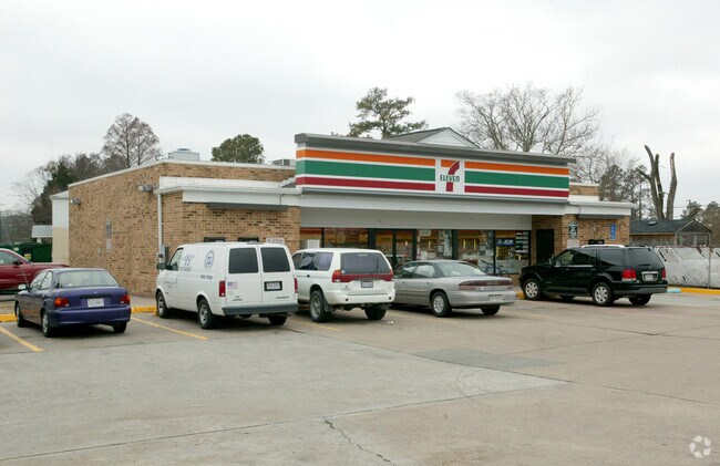
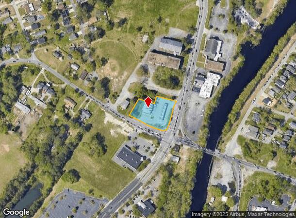
Property Record
120 George Washington Hwy N, Chesapeake, VA 23323
NEARBY LISTINGS FOR SALE OR LEASE
Property Detail
120 George Washington Hwy N
0340000002490
South Mil Geo Wash Corridor
Conveniencestore
PARCEL A1 RESUB PLT RPART 17/DEEP CREEK PROP .969
X
Chesapeake
5100340034D
Virginia
2024
0.97 AC
2025
Deep Creek
021301
Hampton Roads
3,128 SF
Virginia Beach-Norfolk-Newport News, VA-NC
DEMOGRAPHICS near 120 George Washington Hwy N
1 Mile
3 Mile
5 Mile
2024 Total Population
7,842
39,787
101,168
2029 Population
8,232
41,426
103,838
Pop Growth 2024-2029
+ 4.97%
+ 4.12%
+ 2.64%
Average Age
36
37
38
2024 Total Households
2,582
13,321
36,378
HH Growth 2024-2029
+ 5.11%
+ 4.25%
+ 2.65%
Median Household Inc
$109,154
$101,488
$74,879
Avg Household Size
3.00
2.90
2.70
2024 Avg HH Vehicles
2.00
2.00
2.00
Median Home Value
$353,212
$306,181
$278,930
Median Year Built
2000
1992
1985
Nearby Places
Map Layers
Map Styles
 Street
 Aerial
- Restaurants
- Banks
- Shops
- Fitness
- Groceries
PUBLIC TRANSPORTATION
COMMUTER RAIL
Norfolk (Northeast Regional - Amtrak)
DRIVE
WALK
Distance
Norfolk (Northeast Regional - Amtrak)
17 min
9.4 mi
AIRPORT
Norfolk International
DRIVE
WALK
Distance
Norfolk International
28 min
18.6 mi
Newport News/Williamsburg International
DRIVE
WALK
Distance
Newport News/Williamsburg International
50 min
36.7 mi
Freight Ports
Virginia Port Authority - Portsmouth
DRIVE
WALK
Distance
Virginia Port Authority - Portsmouth
20 min
10.0 mi
Nearby Properties
Address
Land Use
TOTAL SIZE
Lot Size
Zoning
Address
Land Use
TOTAL SIZE
Lot Size
Zoning
338,400 SF
96.79 AC
A1: AGRICU
Address
Land Use
TOTAL SIZE
Lot Size
Zoning
120,471 SF
10.32 AC
M1: LIGHT
Address
Land Use
TOTAL SIZE
Lot Size
Zoning
178,068 SF
14.72 AC
M1: LIGHT
Address
Land Use
TOTAL SIZE
Lot Size
Zoning
195,637 SF
96.05 AC
RE1: RESID
Address
Land Use
TOTAL SIZE
Lot Size
Zoning
264,975 SF
50.36 AC
R10S: RESI
Address
Land Use
TOTAL SIZE
Lot Size
Zoning
63,050 SF
27.71 AC
O-I: OFFIC
Address
Land Use
TOTAL SIZE
Lot Size
Zoning
107,223 SF
48.07 AC
O-I: OFFIC
Address
Land Use
TOTAL SIZE
Lot Size
Zoning
148,905 SF
7.32 AC
PUD: PLANN
Address
Land Use
TOTAL SIZE
Lot Size
Zoning
213,740 SF
26.51 AC
B2: GENERA
Address
Land Use
TOTAL SIZE
Lot Size
Zoning
130,510 SF
33.74 AC
M1: LIGHT
Address
Land Use
TOTAL SIZE
Lot Size
Zoning
2,434 SF
39.25 AC
B2: GENERA
Address
Land Use
TOTAL SIZE
Lot Size
Zoning
38,354 SF
2.23 AC
PUD: PLANN
Address
Land Use
TOTAL SIZE
Lot Size
Zoning
4,300 SF
11.21 AC
PUD: PLANN
Address
Land Use
TOTAL SIZE
Lot Size
Zoning
126,250 SF
31.69 AC
R10S: RESI
Address
Land Use
TOTAL SIZE
Lot Size
Zoning
193,534 SF
17.99 AC
M1: LIGHT
Address
Land Use
TOTAL SIZE
Lot Size
Zoning
167,400 SF
10.74 AC
M1: LIGHT
Address
Land Use
TOTAL SIZE
Lot Size
Zoning
197,533 SF
15 AC
M1: LIGHT
Address
Land Use
TOTAL SIZE
Lot Size
Zoning
50,486 SF
11.50 AC
M1: LIGHT
Address
Land Use
TOTAL SIZE
Lot Size
Zoning
59,280 SF
12.23 AC
RMF1: MULT
Address
Land Use
TOTAL SIZE
Lot Size
Zoning
48,360 SF
14.75 AC
M3: WATERF
Address
Land Use
TOTAL SIZE
Lot Size
Zoning
25,610 SF
5.16 AC
B4: SHOPPI
Address
Land Use
TOTAL SIZE
Lot Size
Zoning
20,040 SF
13.34 AC
B2: GENERA
Address
Land Use
TOTAL SIZE
Lot Size
Zoning
65,088 SF
20.50 AC
R10S: RESI
Address
Land Use
TOTAL SIZE
Lot Size
Zoning
41,335 SF
16.35 AC
M1: LIGHT
Address
Land Use
TOTAL SIZE
Lot Size
Zoning
100,792 SF
16.35 AC
R8S: RESID
Address
Land Use
TOTAL SIZE
Lot Size
Zoning
80,496 SF
7.88 AC
RMF1: MULT
Address
Land Use
TOTAL SIZE
Lot Size
Zoning
25,133 SF
34.93 AC
AC: ASSEMB
Address
Land Use
TOTAL SIZE
Lot Size
Zoning
43,800 SF
2.50 AC
PUD: PLANN
Address
Land Use
TOTAL SIZE
Lot Size
Zoning
63,350 SF
9.69 AC
B1: NEIGHB
Address
Land Use
TOTAL SIZE
Lot Size
Zoning
104,750 SF
7.84 AC
RMF1: MULT
The World's #1 Commercial Real Estate Marketplace
Connect with us
© 2025 CoStar Group
The information above has been obtained from sources believed reliable. While we do not doubt its accuracy we have not verified it and make no guarantee, warranty or representation about it. It is your responsibility to independently confirm its accuracy and completeness. Any projections, opinions, assumptions, or estimates used are for example only and do not represent the current or future performance of the property. The value of this transaction to you depends on tax and other factors which should be evaluated by your tax, financial, and legal advisors. You and your advisors should conduct a careful, independent investigation of the property to determine to your satisfaction the suitability of the property for your needs.