Property Record
120 Goddard Memorial Dr, Worcester, MA 01603
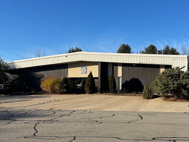

This Property Is For Sale
Current Lease Availabilities
NEARBY LISTINGS FOR SALE OR LEASE
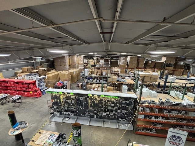
Property Detail
120 Goddard Memorial Dr
WORC-000056-000010-R000000
Holden Indust Park
Manufacturinglight
Worcester
X
Massachusetts
25027C0613E
r
2025
3.36 AC
2025
Worcester Metro
731001
Boston
40,725 SF
Worcester, MA
DEMOGRAPHICS near 120 Goddard Memorial Dr
1 mile
3 mile
5 mile
2024 Total Population
8,256
80,669
186,890
2029 Population
8,216
79,383
184,210
Pop Growth 2024-2029
(0.48%)
(1.59%)
(1.43%)
Average Age
41
39
38
2024 Total Households
3,197
30,501
70,794
HH Growth 2024-2029
(0.44%)
(1.62%)
(1.44%)
Median Household Inc
$69,719
$59,444
$62,571
Avg Household Size
2.50
2.40
2.40
2024 Avg HH Vehicles
2.00
1.00
1.00
Median Home Value
$283,839
$316,611
$322,470
Median Year Built
1972
1948
1949
Nearby Places
Map Layers
Map Styles
 Street
 Aerial
Transit
 Traffic
 Biking
Places
Listings with unknown addresses are not visible on the map
- Restaurants
- Banks
- Shops
- Fitness
- Groceries
PUBLIC TRANSPORTATION
COMMUTER RAIL
Worcester Union Station (Lake Shore Limited - Amtrak)
Drive
Walk
Distance
Worcester Union Station (Lake Shore Limited - Amtrak)
9 min
5.1 mi
Worcester (Framingham/Worcester Line - Massachusetts Bay Transportation Authority Commuter Rail (Purple Line))
Drive
Walk
Distance
Worcester (Framingham/Worcester Line - Massachusetts Bay Transportation Authority Commuter Rail (Purple Line))
10 min
5.3 mi
AIRPORT
Worcester Regional
Drive
Walk
Distance
Worcester Regional
7 min
2.5 mi
Freight Ports
Port of Boston
Drive
Walk
Distance
Port of Boston
69 min
50.4 mi
Nearby Properties
Address
Land Use
TOTAL SIZE
Lot Size
Zoning
Address
Land Use
TOTAL SIZE
Lot Size
Zoning
49.08 AC
SA
Address
Land Use
TOTAL SIZE
Lot Size
Zoning
49.51 AC
IN-S
Address
Land Use
TOTAL SIZE
Lot Size
Zoning
244,486 SF
42.64 AC
RL-7
Address
Land Use
TOTAL SIZE
Lot Size
Zoning
142.98 AC
Address
Land Use
TOTAL SIZE
Lot Size
Zoning
1,760 SF
105.54 AC
ML10
Address
Land Use
TOTAL SIZE
Lot Size
Zoning
177.12 AC
RL-7
Address
Land Use
TOTAL SIZE
Lot Size
Zoning
3.55 AC
RG-5
Address
Land Use
TOTAL SIZE
Lot Size
Zoning
69.46 AC
RS-7
Address
Land Use
TOTAL SIZE
Lot Size
Zoning
3.43 AC
ML10
Address
Land Use
TOTAL SIZE
Lot Size
Zoning
41.84 AC
Address
Land Use
TOTAL SIZE
Lot Size
Zoning
643,250 SF
35.17 AC
RL-7
Address
Land Use
TOTAL SIZE
Lot Size
Zoning
175,200 SF
2.26 AC
BL-1
Address
Land Use
TOTAL SIZE
Lot Size
Zoning
2.78 AC
MG-2
Address
Land Use
TOTAL SIZE
Lot Size
Zoning
188,980 SF
20 AC
RL-7
Address
Land Use
TOTAL SIZE
Lot Size
Zoning
279,977 SF
17.80 AC
Address
Land Use
TOTAL SIZE
Lot Size
Zoning
200 SF
50.14 AC
MG-2
Address
Land Use
TOTAL SIZE
Lot Size
Zoning
10.70 AC
RS-7
Address
Land Use
TOTAL SIZE
Lot Size
Zoning
14.66 AC
BG-2
Address
Land Use
TOTAL SIZE
Lot Size
Zoning
153,745 SF
10.99 AC
MG-2
Address
Land Use
TOTAL SIZE
Lot Size
Zoning
11 AC
RS-7
Address
Land Use
TOTAL SIZE
Lot Size
Zoning
16.06 AC
RS-7
Address
Land Use
TOTAL SIZE
Lot Size
Zoning
70,400 SF
17.10 AC
Address
Land Use
TOTAL SIZE
Lot Size
Zoning
11.28 AC
RL-7
Address
Land Use
TOTAL SIZE
Lot Size
Zoning
153,510 SF
1.67 AC
RG-5
Address
Land Use
TOTAL SIZE
Lot Size
Zoning
12.23 AC
RS-7
Address
Land Use
TOTAL SIZE
Lot Size
Zoning
176,000 SF
19.52 AC
RL-7
Address
Land Use
TOTAL SIZE
Lot Size
Zoning
2,202 SF
11.79 AC
RS-10
Address
Land Use
TOTAL SIZE
Lot Size
Zoning
1,244 SF
40.52 AC
RL-7
Address
Land Use
TOTAL SIZE
Lot Size
Zoning
91,136 SF
2.52 AC
RG-5
The World's #1 Commercial Real Estate Marketplace
Connect with us
© 2026 CoStar Group
The information above has been obtained from sources believed reliable. While we do not doubt its accuracy we have not verified it and make no guarantee, warranty or representation about it. It is your responsibility to independently confirm its accuracy and completeness. Any projections, opinions, assumptions, or estimates used are for example only and do not represent the current or future performance of the property. The value of this transaction to you depends on tax and other factors which should be evaluated by your tax, financial, and legal advisors. You and your advisors should conduct a careful, independent investigation of the property to determine to your satisfaction the suitability of the property for your needs.