Property Record
120 Haskell Rd, Bangor, ME 04401
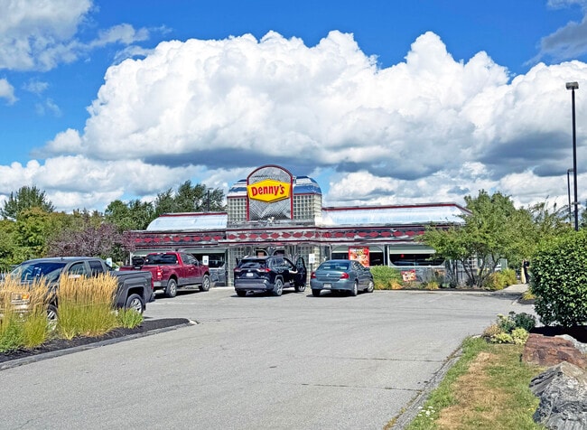


This Property Is For Sale
Property Detail
120 Haskell Rd
BANG-000070R-000000-000001-J000000
Penobscot
Restaurantbuilding
Maine
GC&S
1-j
B and X Area of moderate flood hazard, usually the area between the limits of the 100-year and 500-year floods.
2.01 AC
2024
Maine North & Bangor
2024
Other Market Areas
000300
Bangor, ME
2,890 SF
NEARBY LISTINGS FOR SALE OR LEASE
DEMOGRAPHICS near 120 Haskell Rd
1 mile
3 mile
5 mile
2025 Total Population
532
26,606
50,990
2030 Population
544
26,828
51,872
Pop Growth 2025-2030
+ 2.26%
+ 0.83%
+ 1.73%
Average Age
44
43
43
2025 Total Households
213
12,143
22,835
HH Growth 2025-2030
+ 1.88%
+ 0.72%
+ 1.71%
Median Household Inc
$73,234
$61,622
$64,118
Avg Household Size
2.10
2.00
2.10
2025 Avg HH Vehicles
2.00
1.00
2.00
Median Home Value
$332,353
$260,153
$252,871
Median Year Built
1977
1960
1967
Nearby Places
Map Layers
Map Styles
 Street
 Aerial
Transit
 Traffic
 Biking
Places
Listings with unknown addresses are not visible on the map
- Restaurants
- Banks
- Shops
- Fitness
- Groceries
PUBLIC TRANSPORTATION
AIRPORT
Bangor International
Drive
Walk
Distance
Bangor International
17 min
8.1 mi
Freight Ports
Searsport, ME
Drive
Walk
Distance
Searsport, ME
53 min
33.8 mi
Nearby Properties
Address
Land Use
TOTAL SIZE
Lot Size
Zoning
Address
Land Use
TOTAL SIZE
Lot Size
Zoning
76,649 SF
100 AC
G&ISD
Address
Land Use
TOTAL SIZE
Lot Size
Zoning
307,200 SF
99.21 AC
G&ISD
Address
Land Use
TOTAL SIZE
Lot Size
Zoning
Address
Land Use
TOTAL SIZE
Lot Size
Zoning
11,000 SF
188.98 AC
LDR
Address
Land Use
TOTAL SIZE
Lot Size
Zoning
243,694 SF
2.95 AC
G&ISD
Address
Land Use
TOTAL SIZE
Lot Size
Zoning
124,368 SF
11.75 AC
G&ISD
Address
Land Use
TOTAL SIZE
Lot Size
Zoning
241,898 SF
62.50 AC
G&ISD
Address
Land Use
TOTAL SIZE
Lot Size
Zoning
146,924 SF
2.62 AC
G&ISD
Address
Land Use
TOTAL SIZE
Lot Size
Zoning
100,800 SF
1.34 AC
DDD
Address
Land Use
TOTAL SIZE
Lot Size
Zoning
226,625 SF
S&PS
Address
Land Use
TOTAL SIZE
Lot Size
Zoning
94,081 SF
17.56 AC
G&ISD
Address
Land Use
TOTAL SIZE
Lot Size
Zoning
208,790 SF
50.33 AC
S&PS
Address
Land Use
TOTAL SIZE
Lot Size
Zoning
186,197 SF
21.70 AC
S&PS
Address
Land Use
TOTAL SIZE
Lot Size
Zoning
183,507 SF
44.60 AC
G&ISD
Address
Land Use
TOTAL SIZE
Lot Size
Zoning
109,507 SF
1.96 AC
G&ISD
Address
Land Use
TOTAL SIZE
Lot Size
Zoning
28 AC
HDR
Address
Land Use
TOTAL SIZE
Lot Size
Zoning
29.50 AC
Address
Land Use
TOTAL SIZE
Lot Size
Zoning
G&ISD
Address
Land Use
TOTAL SIZE
Lot Size
Zoning
32,570 SF
1.38 AC
G&ISD
Address
Land Use
TOTAL SIZE
Lot Size
Zoning
604,872 SF
67.61 AC
S&PS
Address
Land Use
TOTAL SIZE
Lot Size
Zoning
140,059 SF
15.38 AC
S&PS
Address
Land Use
TOTAL SIZE
Lot Size
Zoning
44,318 SF
23.67 AC
G&ISD
Address
Land Use
TOTAL SIZE
Lot Size
Zoning
104,534 SF
5 AC
GC&S
Address
Land Use
TOTAL SIZE
Lot Size
Zoning
130,786 SF
17.33 AC
GC&S
Address
Land Use
TOTAL SIZE
Lot Size
Zoning
123,814 SF
11.23 AC
GC&S
Address
Land Use
TOTAL SIZE
Lot Size
Zoning
61,464 SF
20.03 AC
GC&S
Address
Land Use
TOTAL SIZE
Lot Size
Zoning
87,386 SF
13.50 AC
G&ISD
Address
Land Use
TOTAL SIZE
Lot Size
Zoning
72,377 SF
11.97 AC
GC&S
Address
Land Use
TOTAL SIZE
Lot Size
Zoning
122,390 SF
13 AC
S&PS
Address
Land Use
TOTAL SIZE
Lot Size
Zoning
55,514 SF
1.86 AC
G&ISD
The World's #1 Commercial Real Estate Marketplace
Connect with us
© 2026 CoStar Group
The information above has been obtained from sources believed reliable. While we do not doubt its accuracy we have not verified it and make no guarantee, warranty or representation about it. It is your responsibility to independently confirm its accuracy and completeness. Any projections, opinions, assumptions, or estimates used are for example only and do not represent the current or future performance of the property. The value of this transaction to you depends on tax and other factors which should be evaluated by your tax, financial, and legal advisors. You and your advisors should conduct a careful, independent investigation of the property to determine to your satisfaction the suitability of the property for your needs.