Property Record
120 Hermit Smith Rd, Apopka, FL 32703
Property Detail
120 Hermit Smith Rd
Orlando-Kissimmee-Sanford, FL
W1/2 OF SE1/4 OF SE1/4 OF SW1/4 & SW1/4 OF SE1/4 OF SW1/4 SE C 01-21-27
01-2127-0000-00-026
ORANGE
Industrialacreage
Florida
PUD
26
AE The base floodplain where base flood elevations are provided. AE Zones are now used on new format FIRMs instead of A1-A30 Zones.
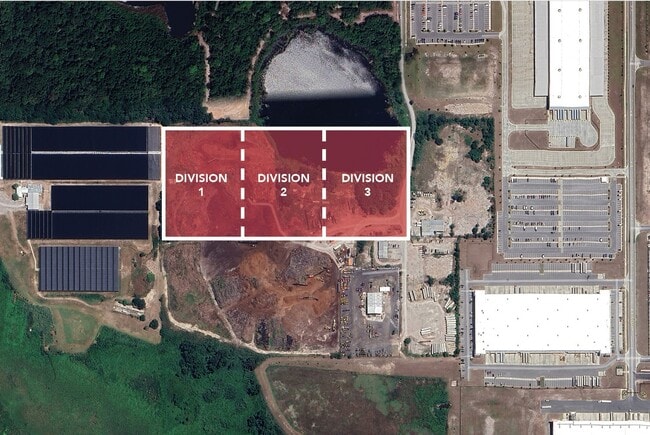
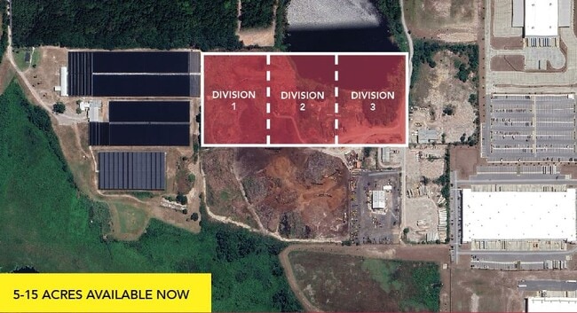
15.17 AC
2025
NW Orange Outlying
2026
Orlando
017901
NEARBY LISTINGS FOR SALE OR LEASE
DEMOGRAPHICS near 120 Hermit Smith Rd
1 mile
3 mile
5 mile
2025 Total Population
949
30,223
76,003
2030 Population
1,083
33,427
83,978
Pop Growth 2025-2030
+ 14.12%
+ 10.60%
+ 10.49%
Average Age
39
42
40
2025 Total Households
317
10,805
25,877
HH Growth 2025-2030
+ 14.51%
+ 10.93%
+ 10.86%
Median Household Inc
$108,833
$102,254
$95,383
Avg Household Size
3.00
2.80
2.90
2025 Avg HH Vehicles
2.00
2.00
2.00
Median Home Value
$443,801
$413,614
$415,827
Median Year Built
2010
2002
2001
Nearby Places
Map Layers
Map Styles
 Street
 Aerial
Layers
 Traffic
 Biking
Places
Listings with unknown addresses are not visible on the map
- Restaurants
- Banks
- Shops
- Fitness
- Groceries
PUBLIC TRANSPORTATION
AIRPORT
Orlando Sanford International
Drive
Walk
Distance
Orlando Sanford International
49 min
32.7 mi
Orlando International
Drive
Walk
Distance
Orlando International
47 min
34.4 mi
Freight Ports
Port Canaveral
Drive
Walk
Distance
Port Canaveral
95 min
76.9 mi
SALE & LEASE HISTORY
LISTING DATE
SALE/LEASE

Apr 04, 2025
For Lease
Nearby Properties
Address
Land Use
TOTAL SIZE
Lot Size
Zoning
Address
Land Use
TOTAL SIZE
Lot Size
Zoning
1,245,063 SF
90.98 AC
PD
Address
Land Use
TOTAL SIZE
Lot Size
Zoning
1,208,666 SF
57.24 AC
PD
Address
Land Use
TOTAL SIZE
Lot Size
Zoning
722,019 SF
35.47 AC
PD
Address
Land Use
TOTAL SIZE
Lot Size
Zoning
546,848 SF
33.62 AC
D-APK-PD
Address
Land Use
TOTAL SIZE
Lot Size
Zoning
588,076 SF
38.89 AC
PD
Address
Land Use
TOTAL SIZE
Lot Size
Zoning
792,152 SF
53.04 AC
O
Address
Land Use
TOTAL SIZE
Lot Size
Zoning
537,895 SF
55.19 AC
I-L
Address
Land Use
TOTAL SIZE
Lot Size
Zoning
372,801 SF
D-APK-PD
Address
Land Use
TOTAL SIZE
Lot Size
Zoning
343,587 SF
9.67 AC
MU-ES-GT
Address
Land Use
TOTAL SIZE
Lot Size
Zoning
265,125 SF
16.27 AC
MU-ES-GT
Address
Land Use
TOTAL SIZE
Lot Size
Zoning
361,418 SF
18.88 AC
MU-ES-GT
Address
Land Use
TOTAL SIZE
Lot Size
Zoning
299,743 SF
PD
Address
Land Use
TOTAL SIZE
Lot Size
Zoning
347,706 SF
20.10 AC
PD
Address
Land Use
TOTAL SIZE
Lot Size
Zoning
350,699 SF
18 AC
D-APK-I-L
Address
Land Use
TOTAL SIZE
Lot Size
Zoning
323,161 SF
43.55 AC
PD
Address
Land Use
TOTAL SIZE
Lot Size
Zoning
293,305 SF
21.60 AC
PD
Address
Land Use
TOTAL SIZE
Lot Size
Zoning
283,364 SF
17.99 AC
D-APK-PD
Address
Land Use
TOTAL SIZE
Lot Size
Zoning
262,515 SF
23 AC
D-APK-PD
Address
Land Use
TOTAL SIZE
Lot Size
Zoning
278,981 SF
51.18 AC
I-L
Address
Land Use
TOTAL SIZE
Lot Size
Zoning
189,514 SF
12.70 AC
MU-ES-GT
Address
Land Use
TOTAL SIZE
Lot Size
Zoning
589,600 SF
19.60 AC
I-L
Address
Land Use
TOTAL SIZE
Lot Size
Zoning
267,044 SF
17.05 AC
D-APK-I-L
Address
Land Use
TOTAL SIZE
Lot Size
Zoning
255,880 SF
15.73 AC
PD
Address
Land Use
TOTAL SIZE
Lot Size
Zoning
133,960 SF
17.21 AC
PD
Address
Land Use
TOTAL SIZE
Lot Size
Zoning
685,777 SF
19.32 AC
I-L
Address
Land Use
TOTAL SIZE
Lot Size
Zoning
207,423 SF
10.76 AC
D-APK-PD
Address
Land Use
TOTAL SIZE
Lot Size
Zoning
275,446 SF
12.81 AC
I-L
Address
Land Use
TOTAL SIZE
Lot Size
Zoning
207,428 SF
10.78 AC
D-APK-PD
Address
Land Use
TOTAL SIZE
Lot Size
Zoning
503,677 SF
27.63 AC
I-L
Address
Land Use
TOTAL SIZE
Lot Size
Zoning
145,106 SF
9.92 AC
D-APK-I-L
The World's #1 Commercial Real Estate Marketplace
Connect with us
© 2026 CoStar Group
The information above has been obtained from sources believed reliable. While we do not doubt its accuracy we have not verified it and make no guarantee, warranty or representation about it. It is your responsibility to independently confirm its accuracy and completeness. Any projections, opinions, assumptions, or estimates used are for example only and do not represent the current or future performance of the property. The value of this transaction to you depends on tax and other factors which should be evaluated by your tax, financial, and legal advisors. You and your advisors should conduct a careful, independent investigation of the property to determine to your satisfaction the suitability of the property for your needs.