Property Record
120 Herron Ave, Cheswick, PA 15024


Property Detail
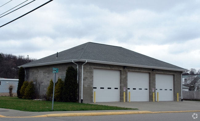
120 Herron Ave
Pittsburgh, PA
SCHOOL PLAN 1 LOT 73.6X135.65 HERRON ST COR GRA NT ST (0.226A) 1 STY CB BLDG
0530-N-00190-0000-00
ALLEGHENY
Policefirecivildefense
Pennsylvania
B and X Area of moderate flood hazard, usually the area between the limits of the 100-year and 500-year floods.
190
2023
0.23 AC
2025
Northeast Pittsburgh
415001
Pittsburgh
NEARBY LISTINGS FOR SALE OR LEASE
DEMOGRAPHICS near 120 Herron Ave
1 mile
3 mile
5 mile
2025 Total Population
3,174
28,869
84,902
2030 Population
3,110
28,418
83,967
Pop Growth 2025-2030
(2.02%)
(1.56%)
(1.10%)
Average Age
48
46
45
2025 Total Households
1,480
13,301
37,898
HH Growth 2025-2030
(2.16%)
(1.60%)
(1.14%)
Median Household Inc
$68,645
$77,969
$74,036
Avg Household Size
2.00
2.10
2.20
2025 Avg HH Vehicles
2.00
2.00
2.00
Median Home Value
$169,981
$225,500
$192,676
Median Year Built
1954
1961
1958
Nearby Places
Map Layers
Map Styles
 Street
 Aerial
Layers
 Traffic
 Biking
Places
Listings with unknown addresses are not visible on the map
- Restaurants
- Banks
- Shops
- Fitness
- Groceries
PUBLIC TRANSPORTATION
AIRPORT
Pittsburgh International
Drive
Walk
Distance
Pittsburgh International
49 min
31.9 mi
Arnold Palmer Regional
Drive
Walk
Distance
Arnold Palmer Regional
56 min
38.2 mi
Nearby Properties
Address
Land Use
TOTAL SIZE
Lot Size
Zoning
Address
Land Use
TOTAL SIZE
Lot Size
Zoning
36.44 AC
Address
Land Use
TOTAL SIZE
Lot Size
Zoning
11.28 AC
Address
Land Use
TOTAL SIZE
Lot Size
Zoning
23.45 AC
Address
Land Use
TOTAL SIZE
Lot Size
Zoning
42.71 AC
Address
Land Use
TOTAL SIZE
Lot Size
Zoning
528.43 AC
Address
Land Use
TOTAL SIZE
Lot Size
Zoning
119.91 AC
Address
Land Use
TOTAL SIZE
Lot Size
Zoning
6.35 AC
Address
Land Use
TOTAL SIZE
Lot Size
Zoning
5.44 AC
Address
Land Use
TOTAL SIZE
Lot Size
Zoning
15.37 AC
Address
Land Use
TOTAL SIZE
Lot Size
Zoning
48.10 AC
Address
Land Use
TOTAL SIZE
Lot Size
Zoning
13.68 AC
Address
Land Use
TOTAL SIZE
Lot Size
Zoning
84.40 AC
Address
Land Use
TOTAL SIZE
Lot Size
Zoning
37.84 AC
Address
Land Use
TOTAL SIZE
Lot Size
Zoning
Address
Land Use
TOTAL SIZE
Lot Size
Zoning
72.14 AC
Address
Land Use
TOTAL SIZE
Lot Size
Zoning
Address
Land Use
TOTAL SIZE
Lot Size
Zoning
10.20 AC
Address
Land Use
TOTAL SIZE
Lot Size
Zoning
1.21 AC
Address
Land Use
TOTAL SIZE
Lot Size
Zoning
23.95 AC
Address
Land Use
TOTAL SIZE
Lot Size
Zoning
Address
Land Use
TOTAL SIZE
Lot Size
Zoning
889 SF
31.93 AC
Address
Land Use
TOTAL SIZE
Lot Size
Zoning
Address
Land Use
TOTAL SIZE
Lot Size
Zoning
21.20 AC
Address
Land Use
TOTAL SIZE
Lot Size
Zoning
12.10 AC
Address
Land Use
TOTAL SIZE
Lot Size
Zoning
1.48 AC
Address
Land Use
TOTAL SIZE
Lot Size
Zoning
1.81 AC
Address
Land Use
TOTAL SIZE
Lot Size
Zoning
114.41 AC
Address
Land Use
TOTAL SIZE
Lot Size
Zoning
20.10 AC
Address
Land Use
TOTAL SIZE
Lot Size
Zoning
Address
Land Use
TOTAL SIZE
Lot Size
Zoning
The World's #1 Commercial Real Estate Marketplace
Connect with us
© 2026 CoStar Group
The information above has been obtained from sources believed reliable. While we do not doubt its accuracy we have not verified it and make no guarantee, warranty or representation about it. It is your responsibility to independently confirm its accuracy and completeness. Any projections, opinions, assumptions, or estimates used are for example only and do not represent the current or future performance of the property. The value of this transaction to you depends on tax and other factors which should be evaluated by your tax, financial, and legal advisors. You and your advisors should conduct a careful, independent investigation of the property to determine to your satisfaction the suitability of the property for your needs.