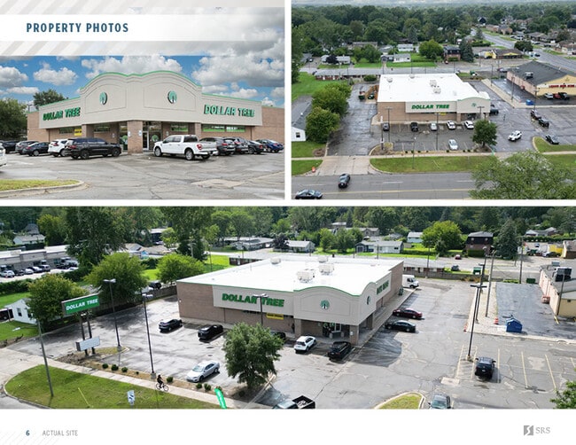
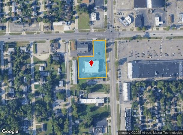
Property Record
120 Inkster Rd, Inkster, MI 48141
NEARBY LISTINGS FOR SALE OR LEASE
Property Detail
120 Inkster Rd
Detroit-Warren-Dearborn, MI
Garden City Crest
44-003-01-0312-304
*24A312B1--318* LOT 312 EXC THE W 150 FT AND THE N 20 FT THEREOF; ALSO LOTS 313 AND 314 COMBINED EXC THE WLY 150 FT THEREOF; ALSO LOT 315 EXC THE WLY 150 FT OF THE N 24.5 FT THEREOF; ALSO LOTS 316 TO 318 INCL--- ASSESSORS INKSTER PLAT NO. 7 T2S R9E L
Drugstorepharmacycvswalgreens
Wayne
X
Michigan
26163C0241E
312-318
2024
1.72 AC
2025
Southern I-275 Corridor
570400
Detroit
13,833 SF
DEMOGRAPHICS near 120 Inkster Rd
1 Mile
3 Mile
5 Mile
2024 Total Population
17,796
122,597
289,496
2029 Population
17,160
118,105
278,936
Pop Growth 2024-2029
(3.57%)
(3.66%)
(3.65%)
Average Age
37
39
39
2024 Total Households
6,414
47,137
115,478
HH Growth 2024-2029
(3.62%)
(3.73%)
(3.68%)
Median Household Inc
$57,643
$61,013
$59,410
Avg Household Size
2.70
2.50
2.40
2024 Avg HH Vehicles
2.00
2.00
2.00
Median Home Value
$158,326
$162,733
$154,735
Median Year Built
1957
1956
1957
Nearby Places
Map Layers
Map Styles
 Street
 Aerial
- Restaurants
- Banks
- Shops
- Fitness
- Groceries
PUBLIC TRANSPORTATION
COMMUTER RAIL
DRIVE
WALK
Distance
12 min
5.2 mi
AIRPORT
Detroit Metro Wayne County
DRIVE
WALK
Distance
Detroit Metro Wayne County
21 min
10.2 mi
Windsor International
DRIVE
WALK
Distance
Windsor International
50 min
26.0 mi
SALE & LEASE HISTORY
LISTING DATE
SALE/LEASE

Sep 26, 2023
For Sale
Nearby Properties
Address
Land Use
TOTAL SIZE
Lot Size
Zoning
Address
Land Use
TOTAL SIZE
Lot Size
Zoning
126,712 SF
4.52 AC
BC
Address
Land Use
TOTAL SIZE
Lot Size
Zoning
188,958 SF
7.71 AC
Address
Land Use
TOTAL SIZE
Lot Size
Zoning
463,642 SF
22.82 AC
Address
Land Use
TOTAL SIZE
Lot Size
Zoning
197,774 SF
11.72 AC
Address
Land Use
TOTAL SIZE
Lot Size
Zoning
328,480 SF
11.54 AC
IA
Address
Land Use
TOTAL SIZE
Lot Size
Zoning
196,930 SF
9.93 AC
Address
Land Use
TOTAL SIZE
Lot Size
Zoning
107,680 SF
7.46 AC
BC
Address
Land Use
TOTAL SIZE
Lot Size
Zoning
138,541 SF
8.65 AC
Address
Land Use
TOTAL SIZE
Lot Size
Zoning
149,735 SF
6.64 AC
Address
Land Use
TOTAL SIZE
Lot Size
Zoning
142,269 SF
8.62 AC
Address
Land Use
TOTAL SIZE
Lot Size
Zoning
Address
Land Use
TOTAL SIZE
Lot Size
Zoning
58,958 SF
2.15 AC
BC
Address
Land Use
TOTAL SIZE
Lot Size
Zoning
127,017 SF
6.91 AC
Address
Land Use
TOTAL SIZE
Lot Size
Zoning
94,353 SF
8.70 AC
BC
Address
Land Use
TOTAL SIZE
Lot Size
Zoning
176,883 SF
10.83 AC
Address
Land Use
TOTAL SIZE
Lot Size
Zoning
93,425 SF
7.75 AC
Address
Land Use
TOTAL SIZE
Lot Size
Zoning
88,769 SF
0.91 AC
IB
Address
Land Use
TOTAL SIZE
Lot Size
Zoning
171,414 SF
23.57 AC
Address
Land Use
TOTAL SIZE
Lot Size
Zoning
53,263 SF
2.80 AC
Address
Land Use
TOTAL SIZE
Lot Size
Zoning
50,974 SF
8.48 AC
Address
Land Use
TOTAL SIZE
Lot Size
Zoning
61,031 SF
5.14 AC
BC
Address
Land Use
TOTAL SIZE
Lot Size
Zoning
47,900 SF
2.34 AC
BC
Address
Land Use
TOTAL SIZE
Lot Size
Zoning
61,200 SF
10.10 AC
Address
Land Use
TOTAL SIZE
Lot Size
Zoning
110,371 SF
8.68 AC
Address
Land Use
TOTAL SIZE
Lot Size
Zoning
42,928 SF
4.88 AC
Address
Land Use
TOTAL SIZE
Lot Size
Zoning
111,699 SF
10.08 AC
Address
Land Use
TOTAL SIZE
Lot Size
Zoning
97,740 SF
4.47 AC
Address
Land Use
TOTAL SIZE
Lot Size
Zoning
99,831 SF
8.54 AC
Address
Land Use
TOTAL SIZE
Lot Size
Zoning
59,199 SF
7.44 AC
RMA
Address
Land Use
TOTAL SIZE
Lot Size
Zoning
149,828 SF
1.78 AC
The World's #1 Commercial Real Estate Marketplace
Connect with us
© 2025 CoStar Group
The information above has been obtained from sources believed reliable. While we do not doubt its accuracy we have not verified it and make no guarantee, warranty or representation about it. It is your responsibility to independently confirm its accuracy and completeness. Any projections, opinions, assumptions, or estimates used are for example only and do not represent the current or future performance of the property. The value of this transaction to you depends on tax and other factors which should be evaluated by your tax, financial, and legal advisors. You and your advisors should conduct a careful, independent investigation of the property to determine to your satisfaction the suitability of the property for your needs.