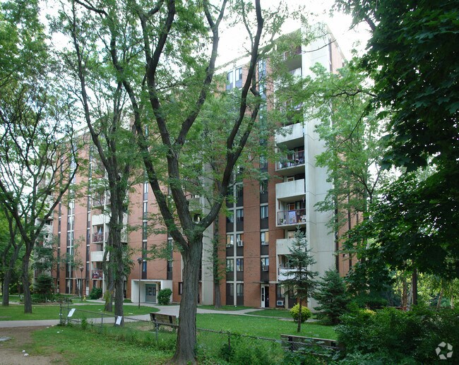
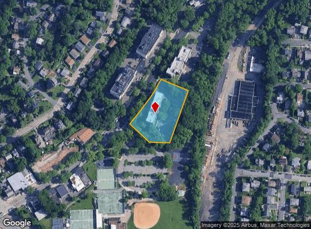
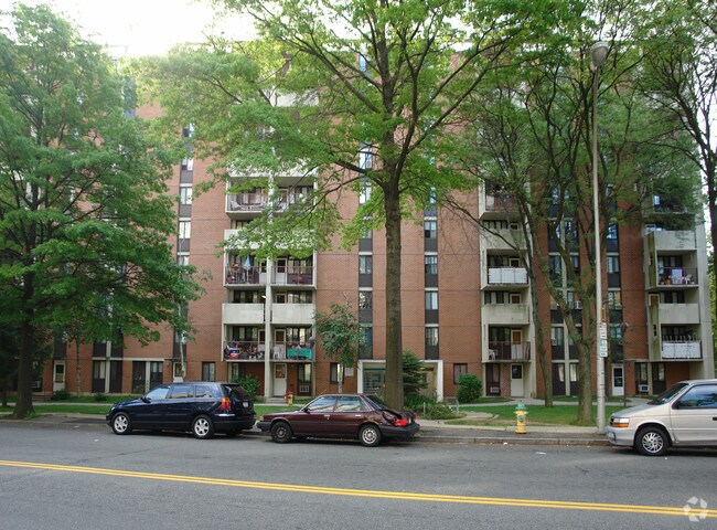
Property Record
120 Lake St, White Plains, NY 10604
NEARBY LISTINGS FOR SALE OR LEASE
Property Detail
120 Lake St
1700-126-009-00009-000-0004
Westchester
Apartment
New York
X
4.000
36119C0267F
1.64 AC
2025
North White Plains
2024
Westchester/So Connecticut
008902
New York-Jersey City-White Plains, NY-NJ
DEMOGRAPHICS near 120 Lake St
1 Mile
3 Mile
5 Mile
2024 Total Population
26,080
101,895
193,532
2029 Population
25,662
100,679
190,598
Pop Growth 2024-2029
(1.60%)
(1.19%)
(1.52%)
Average Age
42
42
42
2024 Total Households
11,669
39,997
70,899
HH Growth 2024-2029
(1.45%)
(1.18%)
(1.55%)
Median Household Inc
$103,804
$120,564
$141,468
Avg Household Size
2.10
2.40
2.60
2024 Avg HH Vehicles
1.00
2.00
2.00
Median Home Value
$499,082
$625,022
$739,984
Median Year Built
1962
1961
1960
Nearby Places
- Restaurants
- Banks
- Shops
- Fitness
- Groceries
PUBLIC TRANSPORTATION
COMMUTER RAIL
White Plains Station (Harlem Line - Metro-North Commuter Railroad Company (Metro-North))
DRIVE
WALK
Distance
White Plains Station (Harlem Line - Metro-North Commuter Railroad Company (Metro-North))
3 min
1.4 mi
North White Plains Station (Harlem Line - Metro-North Commuter Railroad Company (Metro-North))
DRIVE
WALK
Distance
North White Plains Station (Harlem Line - Metro-North Commuter Railroad Company (Metro-North))
4 min
1.8 mi
AIRPORT
Westchester County
DRIVE
WALK
Distance
Westchester County
10 min
5.1 mi
LaGuardia
DRIVE
WALK
Distance
LaGuardia
43 min
24.4 mi
John F Kennedy International
DRIVE
WALK
Distance
John F Kennedy International
49 min
32.0 mi
Freight Ports
NY - Red Hook Container Terminal
DRIVE
WALK
Distance
NY - Red Hook Container Terminal
57 min
38.3 mi
Nearby Properties
Address
Land Use
TOTAL SIZE
Lot Size
Zoning
Address
Land Use
TOTAL SIZE
Lot Size
Zoning
358.83 AC
Address
Land Use
TOTAL SIZE
Lot Size
Zoning
4.45 AC
B
Address
Land Use
TOTAL SIZE
Lot Size
Zoning
75.87 AC
R-20
Address
Land Use
TOTAL SIZE
Lot Size
Zoning
16.22 AC
UR
Address
Land Use
TOTAL SIZE
Lot Size
Zoning
22.44 AC
R-20
Address
Land Use
TOTAL SIZE
Lot Size
Zoning
7.98 AC
CA
Address
Land Use
TOTAL SIZE
Lot Size
Zoning
1,975 SF
13.80 AC
CA
Address
Land Use
TOTAL SIZE
Lot Size
Zoning
29.42 AC
PUD
Address
Land Use
TOTAL SIZE
Lot Size
Zoning
10.90 AC
UR
Address
Land Use
TOTAL SIZE
Lot Size
Zoning
3.16 AC
Address
Land Use
TOTAL SIZE
Lot Size
Zoning
64.41 AC
R-20
Address
Land Use
TOTAL SIZE
Lot Size
Zoning
477.23 AC
Address
Land Use
TOTAL SIZE
Lot Size
Zoning
1,200 SF
21.21 AC
R-20
Address
Land Use
TOTAL SIZE
Lot Size
Zoning
7.98 AC
M-14
Address
Land Use
TOTAL SIZE
Lot Size
Zoning
0.58 AC
B
Address
Land Use
TOTAL SIZE
Lot Size
Zoning
84,450 SF
3.19 AC
B
Address
Land Use
TOTAL SIZE
Lot Size
Zoning
5.43 AC
R-40
Address
Land Use
TOTAL SIZE
Lot Size
Zoning
320 SF
5.38 AC
LI
Address
Land Use
TOTAL SIZE
Lot Size
Zoning
1,348 SF
5.67 AC
CA
Address
Land Use
TOTAL SIZE
Lot Size
Zoning
6.09 AC
DS
Address
Land Use
TOTAL SIZE
Lot Size
Zoning
1,630 SF
2.64 AC
LOB
Address
Land Use
TOTAL SIZE
Lot Size
Zoning
68,616 SF
3.11 AC
Address
Land Use
TOTAL SIZE
Lot Size
Zoning
8.05 AC
R-10
Address
Land Use
TOTAL SIZE
Lot Size
Zoning
5.37 AC
R-20
Address
Land Use
TOTAL SIZE
Lot Size
Zoning
9.73 AC
OB-1
Address
Land Use
TOTAL SIZE
Lot Size
Zoning
1.21 AC
B
Address
Land Use
TOTAL SIZE
Lot Size
Zoning
8.36 AC
Address
Land Use
TOTAL SIZE
Lot Size
Zoning
3.12 AC
LI
Address
Land Use
TOTAL SIZE
Lot Size
Zoning
3.96 AC
LI
Address
Land Use
TOTAL SIZE
Lot Size
Zoning
11.13 AC
DS
The World's #1 Commercial Real Estate Marketplace
Connect with us
© 2025 CoStar Group
The information above has been obtained from sources believed reliable. While we do not doubt its accuracy we have not verified it and make no guarantee, warranty or representation about it. It is your responsibility to independently confirm its accuracy and completeness. Any projections, opinions, assumptions, or estimates used are for example only and do not represent the current or future performance of the property. The value of this transaction to you depends on tax and other factors which should be evaluated by your tax, financial, and legal advisors. You and your advisors should conduct a careful, independent investigation of the property to determine to your satisfaction the suitability of the property for your needs.