Property Record
120 N 4Th Ave, Beech Grove, IN 46107
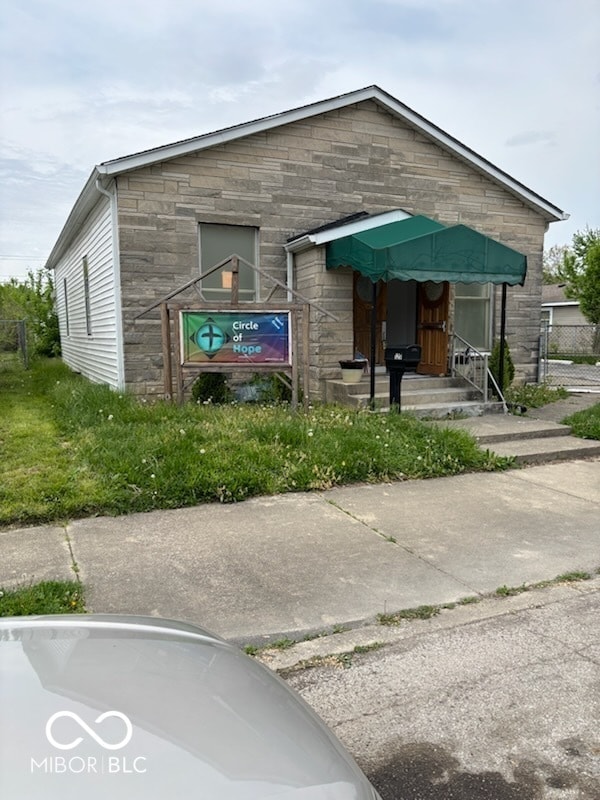

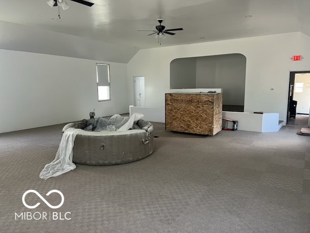
This Property Is For Sale
NEARBY LISTINGS FOR SALE OR LEASE
Property Detail
120 N 4Th Ave
Indianapolis-Carmel-Anderson, IN
Beech Grove Add Sec D
49-10-21-117-320.000-102
Marion
Sfr
Indiana
X
0.12 AC
18097C0252F
Garfield Park
880 SF
Indianapolis
DEMOGRAPHICS near 120 N 4Th Ave
1 Mile
3 Mile
5 Mile
2024 Total Population
8,000
79,019
229,554
2029 Population
7,786
78,288
229,425
Pop Growth 2024-2029
(2.68%)
(0.93%)
(0.06%)
Average Age
39
37
37
2024 Total Households
3,356
30,660
93,338
HH Growth 2024-2029
(2.80%)
(1.04%)
(0.04%)
Median Household Inc
$56,435
$53,620
$58,638
Avg Household Size
2.40
2.50
2.30
2024 Avg HH Vehicles
2.00
2.00
2.00
Median Home Value
$140,455
$145,268
$176,898
Median Year Built
1957
1963
1961
Nearby Places
Map Layers
Map Styles
 Street
 Aerial
- Restaurants
- Banks
- Shops
- Fitness
- Groceries
PUBLIC TRANSPORTATION
COMMUTER RAIL
DRIVE
WALK
Distance
11 min
5.8 mi
AIRPORT
Indianapolis International
DRIVE
WALK
Distance
Indianapolis International
31 min
16.6 mi
Nearby Properties
Address
Land Use
TOTAL SIZE
Lot Size
Zoning
Address
Land Use
TOTAL SIZE
Lot Size
Zoning
41.83 AC
ZO01
Address
Land Use
TOTAL SIZE
Lot Size
Zoning
1,202,700 SF
77.25 AC
ZO01
Address
Land Use
TOTAL SIZE
Lot Size
Zoning
19,927 SF
28.82 AC
ZO01
Address
Land Use
TOTAL SIZE
Lot Size
Zoning
9,888 SF
124.20 AC
ZO01
Address
Land Use
TOTAL SIZE
Lot Size
Zoning
80,348 SF
2.95 AC
ZO01
Address
Land Use
TOTAL SIZE
Lot Size
Zoning
3.82 AC
ZO01
Address
Land Use
TOTAL SIZE
Lot Size
Zoning
405,664 SF
35.56 AC
ZO01
Address
Land Use
TOTAL SIZE
Lot Size
Zoning
51,196 SF
50.61 AC
ZO01
Address
Land Use
TOTAL SIZE
Lot Size
Zoning
352,000 SF
22.72 AC
ZO01
Address
Land Use
TOTAL SIZE
Lot Size
Zoning
3,003 SF
3.52 AC
ZO01
Address
Land Use
TOTAL SIZE
Lot Size
Zoning
1,660 SF
15.01 AC
ZO01
Address
Land Use
TOTAL SIZE
Lot Size
Zoning
405 SF
23.81 AC
ZO01
Address
Land Use
TOTAL SIZE
Lot Size
Zoning
2,486 SF
13.75 AC
ZO01
Address
Land Use
TOTAL SIZE
Lot Size
Zoning
4,179 SF
28.11 AC
ZO01
Address
Land Use
TOTAL SIZE
Lot Size
Zoning
4,212 SF
16 AC
Address
Land Use
TOTAL SIZE
Lot Size
Zoning
208,224 SF
23.41 AC
ZO01
Address
Land Use
TOTAL SIZE
Lot Size
Zoning
4,872 SF
12.37 AC
Address
Land Use
TOTAL SIZE
Lot Size
Zoning
1,575 SF
10.24 AC
Address
Land Use
TOTAL SIZE
Lot Size
Zoning
1,040 SF
15.62 AC
ZO01
Address
Land Use
TOTAL SIZE
Lot Size
Zoning
101,122 SF
16.44 AC
Address
Land Use
TOTAL SIZE
Lot Size
Zoning
38,598 SF
2.83 AC
ZO01
Address
Land Use
TOTAL SIZE
Lot Size
Zoning
61,750 SF
18.59 AC
Address
Land Use
TOTAL SIZE
Lot Size
Zoning
209,756 SF
12.33 AC
ZO01
Address
Land Use
TOTAL SIZE
Lot Size
Zoning
87,807 SF
9.04 AC
ZO01
Address
Land Use
TOTAL SIZE
Lot Size
Zoning
151,946 SF
15.04 AC
Address
Land Use
TOTAL SIZE
Lot Size
Zoning
121,055 SF
12.71 AC
ZO01
Address
Land Use
TOTAL SIZE
Lot Size
Zoning
20,944 SF
8.27 AC
ZO01
Address
Land Use
TOTAL SIZE
Lot Size
Zoning
13,876 SF
28.93 AC
ZO01
Address
Land Use
TOTAL SIZE
Lot Size
Zoning
24,808 SF
6.90 AC
ZO01
Address
Land Use
TOTAL SIZE
Lot Size
Zoning
27,703 SF
22 AC
The World's #1 Commercial Real Estate Marketplace
Connect with us
© 2026 CoStar Group
The information above has been obtained from sources believed reliable. While we do not doubt its accuracy we have not verified it and make no guarantee, warranty or representation about it. It is your responsibility to independently confirm its accuracy and completeness. Any projections, opinions, assumptions, or estimates used are for example only and do not represent the current or future performance of the property. The value of this transaction to you depends on tax and other factors which should be evaluated by your tax, financial, and legal advisors. You and your advisors should conduct a careful, independent investigation of the property to determine to your satisfaction the suitability of the property for your needs.