Property Record
120 N Munger St, Pasadena, TX 77506


Save to a Folder
{{folder.Name}}
{{folder.ListingIds.length}} Properties
{{folder.ListingIds.length}} Property
Create a New Folder
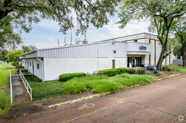
Property Detail
120 N Munger St
Houston-Pasadena-The Woodlands, TX
LTS 7 THRU 24 GUINN
0680560000007
HARRIS
Warehouse
Texas
AE The base floodplain where base flood elevations are provided. AE Zones are now used on new format FIRMs instead of A1-A30 Zones.
7-24
2025
2.85 AC
2025
East-Southeast Far
324101
Houston
29,940 SF
NEARBY LISTINGS FOR SALE OR LEASE
DEMOGRAPHICS near 120 N Munger St
1 mile
3 mile
5 mile
2025 Total Population
10,822
94,538
280,929
2030 Population
11,650
100,693
300,281
Pop Growth 2025-2030
+ 7.65%
+ 6.51%
+ 6.89%
Average Age
34
35
36
2025 Total Households
3,399
28,360
89,596
HH Growth 2025-2030
+ 7.97%
+ 6.76%
+ 7.12%
Median Household Inc
$50,317
$58,652
$54,818
Avg Household Size
3.10
3.30
3.10
2025 Avg HH Vehicles
2.00
2.00
2.00
Median Home Value
$135,287
$164,485
$174,056
Median Year Built
1962
1960
1968
Nearby Places
Map Layers
Map Styles
 Street
 Aerial
Layers
 Traffic
 Biking
Places
Listings with unknown addresses are not visible on the map
- Restaurants
- Banks
- Shops
- Fitness
- Groceries
PUBLIC TRANSPORTATION
AIRPORT
William P Hobby
Drive
Walk
Distance
William P Hobby
21 min
9.4 mi
George Bush Intcntl/Houston
Drive
Walk
Distance
George Bush Intcntl/Houston
37 min
28.3 mi
Freight Ports
Port of Houston
Drive
Walk
Distance
Port of Houston
13 min
6.7 mi
SALE & LEASE HISTORY
LISTING DATE
SALE/LEASE

Apr 14, 2021
For Lease
Apr 14, 2021
For Sale
Nearby Properties
Address
Land Use
TOTAL SIZE
Lot Size
Zoning
Address
Land Use
TOTAL SIZE
Lot Size
Zoning
Address
Land Use
TOTAL SIZE
Lot Size
Zoning
65.22 AC
Address
Land Use
TOTAL SIZE
Lot Size
Zoning
256.70 AC
Address
Land Use
TOTAL SIZE
Lot Size
Zoning
108.84 AC
Address
Land Use
TOTAL SIZE
Lot Size
Zoning
13,460,439 SF
191.66 AC
Address
Land Use
TOTAL SIZE
Lot Size
Zoning
5,379,424 SF
145.51 AC
Address
Land Use
TOTAL SIZE
Lot Size
Zoning
873,718 SF
49.59 AC
Address
Land Use
TOTAL SIZE
Lot Size
Zoning
134.46 AC
Address
Land Use
TOTAL SIZE
Lot Size
Zoning
1,456,582 SF
93.83 AC
Address
Land Use
TOTAL SIZE
Lot Size
Zoning
4,574,044 SF
102.55 AC
Address
Land Use
TOTAL SIZE
Lot Size
Zoning
1,970,716 SF
118.84 AC
Address
Land Use
TOTAL SIZE
Lot Size
Zoning
592,980 SF
20 AC
Address
Land Use
TOTAL SIZE
Lot Size
Zoning
143.17 AC
Address
Land Use
TOTAL SIZE
Lot Size
Zoning
2,019,000 SF
20 AC
Address
Land Use
TOTAL SIZE
Lot Size
Zoning
486.59 AC
Address
Land Use
TOTAL SIZE
Lot Size
Zoning
3,934,000 SF
Address
Land Use
TOTAL SIZE
Lot Size
Zoning
1,476,300 SF
39.05 AC
Address
Land Use
TOTAL SIZE
Lot Size
Zoning
4.26 AC
Address
Land Use
TOTAL SIZE
Lot Size
Zoning
165.53 AC
Address
Land Use
TOTAL SIZE
Lot Size
Zoning
158.48 AC
Address
Land Use
TOTAL SIZE
Lot Size
Zoning
72.68 AC
Address
Land Use
TOTAL SIZE
Lot Size
Zoning
3,568,104 SF
61.61 AC
Address
Land Use
TOTAL SIZE
Lot Size
Zoning
115.83 AC
Address
Land Use
TOTAL SIZE
Lot Size
Zoning
7.19 AC
Address
Land Use
TOTAL SIZE
Lot Size
Zoning
2,918,000 SF
69.31 AC
Address
Land Use
TOTAL SIZE
Lot Size
Zoning
1,978,100 SF
50.02 AC
Address
Land Use
TOTAL SIZE
Lot Size
Zoning
2,124,914 SF
243.08 AC
Address
Land Use
TOTAL SIZE
Lot Size
Zoning
4,580,000 SF
42.82 AC
Address
Land Use
TOTAL SIZE
Lot Size
Zoning
2,367,893 SF
39.85 AC
Address
Land Use
TOTAL SIZE
Lot Size
Zoning
403,776 SF
21.06 AC
The World's #1 Commercial Real Estate Marketplace
Connect with us
© 2026 CoStar Group
The information above has been obtained from sources believed reliable. While we do not doubt its accuracy we have not verified it and make no guarantee, warranty or representation about it. It is your responsibility to independently confirm its accuracy and completeness. Any projections, opinions, assumptions, or estimates used are for example only and do not represent the current or future performance of the property. The value of this transaction to you depends on tax and other factors which should be evaluated by your tax, financial, and legal advisors. You and your advisors should conduct a careful, independent investigation of the property to determine to your satisfaction the suitability of the property for your needs.