Property Record
120 N Nevarez Rd, El Paso, TX 79927

NEARBY LISTINGS FOR SALE OR LEASE
-
-
View all El Paso listings for sale on LoopNet.com
Property Detail
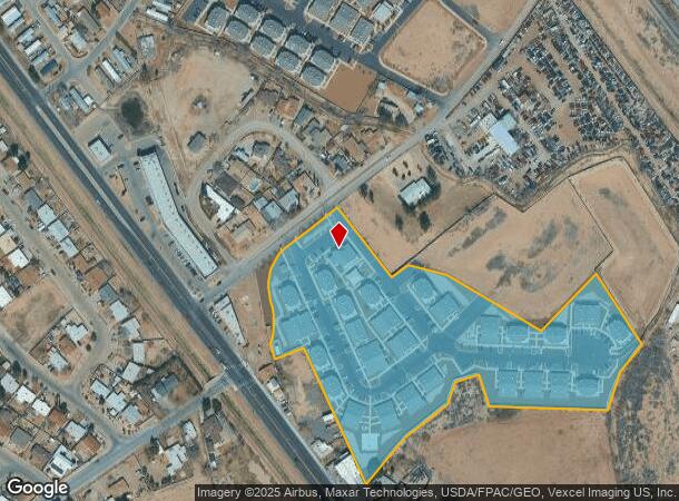
120 N Nevarez Rd
El Paso
Nevarez Palms
El Paso, TX
BLK 1 NEVAREZ PALMS LOT 1
N097-000-0010-0100
El Paso
Apartment
Texas
2024
1
2025
9.83 AC
004006
Outer Socorro
125,158 SF
DEMOGRAPHICS near 120 N Nevarez Rd
1 Mile
3 Mile
5 Mile
2024 Total Population
10,914
51,056
127,130
2029 Population
11,026
51,638
129,016
Pop Growth 2024-2029
+ 1.03%
+ 1.14%
+ 1.48%
Average Age
38
37
36
2024 Total Households
3,356
16,353
40,541
HH Growth 2024-2029
+ 0.92%
+ 1.14%
+ 1.42%
Median Household Inc
$39,393
$42,022
$47,720
Avg Household Size
3.20
3.10
3.10
2024 Avg HH Vehicles
2.00
2.00
2.00
Median Home Value
$107,710
$114,303
$135,564
Median Year Built
1988
1986
1992
Nearby Places
Map Layers
Map Styles
 Street
 Aerial
- Restaurants
- Banks
- Shops
- Fitness
- Groceries
PUBLIC TRANSPORTATION
AIRPORT
El Paso International
DRIVE
WALK
Distance
El Paso International
29 min
15.0 mi
Freight Ports
Port of Corpus Christi
DRIVE
WALK
Distance
Port of Corpus Christi
666 min
681.1 mi
Nearby Properties
Address
Land Use
TOTAL SIZE
Lot Size
Zoning
Address
Land Use
TOTAL SIZE
Lot Size
Zoning
2,562,545 SF
62.04 AC
Address
Land Use
TOTAL SIZE
Lot Size
Zoning
770,870 SF
44.65 AC
Address
Land Use
TOTAL SIZE
Lot Size
Zoning
800,449 SF
50.57 AC
Address
Land Use
TOTAL SIZE
Lot Size
Zoning
393,206 SF
66.48 AC
SU
Address
Land Use
TOTAL SIZE
Lot Size
Zoning
123,306 SF
53.62 AC
M1
Address
Land Use
TOTAL SIZE
Lot Size
Zoning
366,600 SF
21.24 AC
Address
Land Use
TOTAL SIZE
Lot Size
Zoning
392,214 SF
29.67 AC
Address
Land Use
TOTAL SIZE
Lot Size
Zoning
89,251 SF
9.39 AC
AM
Address
Land Use
TOTAL SIZE
Lot Size
Zoning
400,929 SF
30.05 AC
Address
Land Use
TOTAL SIZE
Lot Size
Zoning
652,080 SF
32.64 AC
Address
Land Use
TOTAL SIZE
Lot Size
Zoning
656,540 SF
36.94 AC
M1S
Address
Land Use
TOTAL SIZE
Lot Size
Zoning
127,840 SF
17.66 AC
Address
Land Use
TOTAL SIZE
Lot Size
Zoning
334,161 SF
20.28 AC
Address
Land Use
TOTAL SIZE
Lot Size
Zoning
230,263 SF
27.25 AC
C3S
Address
Land Use
TOTAL SIZE
Lot Size
Zoning
274,580 SF
13.86 AC
C4S
Address
Land Use
TOTAL SIZE
Lot Size
Zoning
179,391 SF
8.23 AC
SD
Address
Land Use
TOTAL SIZE
Lot Size
Zoning
253,144 SF
3 AC
C2
Address
Land Use
TOTAL SIZE
Lot Size
Zoning
180,139 SF
24.81 AC
Address
Land Use
TOTAL SIZE
Lot Size
Zoning
110,080 SF
10.36 AC
Address
Land Use
TOTAL SIZE
Lot Size
Zoning
347,235 SF
33.50 AC
A2
Address
Land Use
TOTAL SIZE
Lot Size
Zoning
215,378 SF
9.60 AC
M1
Address
Land Use
TOTAL SIZE
Lot Size
Zoning
475,547 SF
26.82 AC
Address
Land Use
TOTAL SIZE
Lot Size
Zoning
281,279 SF
14.74 AC
C4
Address
Land Use
TOTAL SIZE
Lot Size
Zoning
129,165 SF
13.17 AC
A2
Address
Land Use
TOTAL SIZE
Lot Size
Zoning
210,794 SF
13.90 AC
Address
Land Use
TOTAL SIZE
Lot Size
Zoning
79,402 SF
2.61 AC
Address
Land Use
TOTAL SIZE
Lot Size
Zoning
171,675 SF
12.66 AC
C4S
Address
Land Use
TOTAL SIZE
Lot Size
Zoning
80,499 SF
25.31 AC
Address
Land Use
TOTAL SIZE
Lot Size
Zoning
210,863 SF
10 AC
M1S
Address
Land Use
TOTAL SIZE
Lot Size
Zoning
123,256 SF
39.56 AC
C4
The World's #1 Commercial Real Estate Marketplace
Connect with us
© 2025 CoStar Group
The information above has been obtained from sources believed reliable. While we do not doubt its accuracy we have not verified it and make no guarantee, warranty or representation about it. It is your responsibility to independently confirm its accuracy and completeness. Any projections, opinions, assumptions, or estimates used are for example only and do not represent the current or future performance of the property. The value of this transaction to you depends on tax and other factors which should be evaluated by your tax, financial, and legal advisors. You and your advisors should conduct a careful, independent investigation of the property to determine to your satisfaction the suitability of the property for your needs.