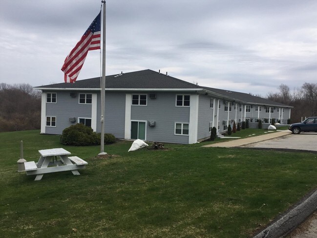
Property Record
120 Putnam Rd, Pomfret Center, CT 06259


Save to a Folder
{{folder.Name}}
{{folder.ListingIds.length}} Properties
{{folder.ListingIds.length}} Property
Create a New Folder
Property Detail
120 Putnam Rd
POMF-000009-F000000-000018
WINDHAM
Apartmenthouse5plusunits
Connecticut
RR
18.00
B and X Area of moderate flood hazard, usually the area between the limits of the 100-year and 500-year floods.
9.95 AC
2025
Windham County
2025
Hartford
902500
Willimantic, CT
28,187 SF
NEARBY LISTINGS FOR SALE OR LEASE
DEMOGRAPHICS near 120 Putnam Rd
1 mile
3 mile
5 mile
2025 Total Population
732
7,921
19,833
2030 Population
717
8,037
20,270
Pop Growth 2025-2030
(2.05%)
+ 1.46%
+ 2.20%
Average Age
39
43
43
2025 Total Households
209
3,246
8,152
HH Growth 2025-2030
(3.35%)
+ 1.66%
+ 2.33%
Median Household Inc
$126,042
$81,701
$85,000
Avg Household Size
2.40
2.30
2.40
2025 Avg HH Vehicles
2.00
2.00
2.00
Median Home Value
$452,857
$317,177
$314,221
Median Year Built
1984
1964
1967
Nearby Places
Map Layers
Map Styles
 Street
 Aerial
Layers
 Traffic
 Biking
Places
Listings with unknown addresses are not visible on the map
- Restaurants
- Banks
- Shops
- Fitness
- Groceries
PUBLIC TRANSPORTATION
AIRPORT
Worcester Regional
Drive
Walk
Distance
Worcester Regional
49 min
32.0 mi
Rhode Island Tf Green International
Drive
Walk
Distance
Rhode Island Tf Green International
59 min
43.6 mi
Freight Ports
Port of Davisville, RI
Drive
Walk
Distance
Port of Davisville, RI
71 min
52.8 mi
Nearby Properties
Address
Land Use
TOTAL SIZE
Lot Size
Zoning
Address
Land Use
TOTAL SIZE
Lot Size
Zoning
13.76 AC
M/OD
Address
Land Use
TOTAL SIZE
Lot Size
Zoning
7,883 SF
141.24 AC
PSR
Address
Land Use
TOTAL SIZE
Lot Size
Zoning
199,059 SF
31.65 AC
R-10
Address
Land Use
TOTAL SIZE
Lot Size
Zoning
16,392 SF
101.85 AC
PSR
Address
Land Use
TOTAL SIZE
Lot Size
Zoning
104,330 SF
15 AC
R-10
Address
Land Use
TOTAL SIZE
Lot Size
Zoning
119.01 AC
Address
Land Use
TOTAL SIZE
Lot Size
Zoning
17.41 AC
GC
Address
Land Use
TOTAL SIZE
Lot Size
Zoning
65,888 SF
9.40 AC
RR
Address
Land Use
TOTAL SIZE
Lot Size
Zoning
25.60 AC
PSR
Address
Land Use
TOTAL SIZE
Lot Size
Zoning
45.60 AC
RR
Address
Land Use
TOTAL SIZE
Lot Size
Zoning
92,080 SF
7.10 AC
I
Address
Land Use
TOTAL SIZE
Lot Size
Zoning
20,644 SF
80.30 AC
AG-2
Address
Land Use
TOTAL SIZE
Lot Size
Zoning
27.10 AC
BV/CB
Address
Land Use
TOTAL SIZE
Lot Size
Zoning
49,195 SF
8.57 AC
AG-2
Address
Land Use
TOTAL SIZE
Lot Size
Zoning
10.08 AC
R-10
Address
Land Use
TOTAL SIZE
Lot Size
Zoning
85,301 SF
47.97 AC
I
Address
Land Use
TOTAL SIZE
Lot Size
Zoning
80,010 SF
9 AC
I
Address
Land Use
TOTAL SIZE
Lot Size
Zoning
72,281 SF
2.84 AC
R-10
Address
Land Use
TOTAL SIZE
Lot Size
Zoning
13.06 AC
I
Address
Land Use
TOTAL SIZE
Lot Size
Zoning
3.03 AC
M/OD
Address
Land Use
TOTAL SIZE
Lot Size
Zoning
62,624 SF
14.25 AC
I
Address
Land Use
TOTAL SIZE
Lot Size
Zoning
41,730 SF
21.30 AC
RR
Address
Land Use
TOTAL SIZE
Lot Size
Zoning
135,012 SF
31.12 AC
0
Address
Land Use
TOTAL SIZE
Lot Size
Zoning
16.40 AC
PSR
Address
Land Use
TOTAL SIZE
Lot Size
Zoning
52,724 SF
6.46 AC
SZD
Address
Land Use
TOTAL SIZE
Lot Size
Zoning
15,002 SF
6.27 AC
M/OD
Address
Land Use
TOTAL SIZE
Lot Size
Zoning
65,380 SF
11.25 AC
I
Address
Land Use
TOTAL SIZE
Lot Size
Zoning
4.60 AC
I
Address
Land Use
TOTAL SIZE
Lot Size
Zoning
37,072 SF
3.79 AC
PSR
Address
Land Use
TOTAL SIZE
Lot Size
Zoning
15,859 SF
0.65 AC
GC
The World's #1 Commercial Real Estate Marketplace
Connect with us
© 2026 CoStar Group
The information above has been obtained from sources believed reliable. While we do not doubt its accuracy we have not verified it and make no guarantee, warranty or representation about it. It is your responsibility to independently confirm its accuracy and completeness. Any projections, opinions, assumptions, or estimates used are for example only and do not represent the current or future performance of the property. The value of this transaction to you depends on tax and other factors which should be evaluated by your tax, financial, and legal advisors. You and your advisors should conduct a careful, independent investigation of the property to determine to your satisfaction the suitability of the property for your needs.