Property Record
120 Rock Island Rd, East Wenatchee, WA 98802
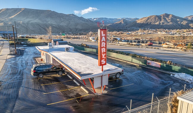
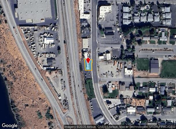
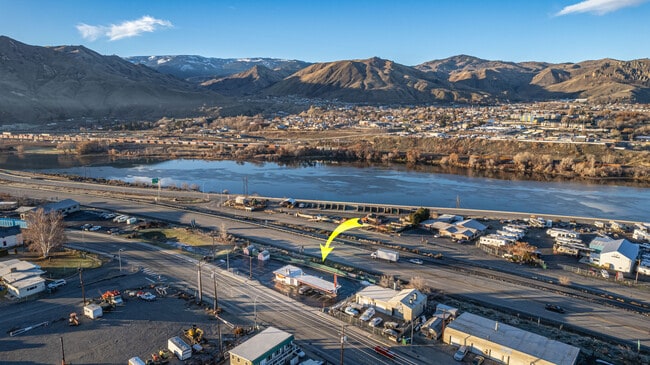
This Property Is For Sale
NEARBY LISTINGS FOR SALE OR LEASE
-
-
View all East Wenatchee listings for sale on LoopNet.com
Property Detail
120 Rock Island Rd
Other Market Areas
Gellatly Add
Wenatchee, WA
LOT 4-E OF HY.; BLK. 1; EX E 5; THAYER & GELLATLY ADD
07-30-01-00401
Douglas
Restaurantbuilding
Washington
2024
4-e
2025
0.15 AC
950800
Washington State Area
346 SF
DEMOGRAPHICS near 120 Rock Island Rd
1 Mile
3 Mile
5 Mile
2024 Total Population
9,726
55,300
73,900
2029 Population
10,220
58,120
77,550
Pop Growth 2024-2029
+ 5.08%
+ 5.10%
+ 4.94%
Average Age
35
39
39
2024 Total Households
3,265
20,327
27,436
HH Growth 2024-2029
+ 5.30%
+ 5.06%
+ 4.90%
Median Household Inc
$53,357
$65,242
$68,662
Avg Household Size
2.90
2.60
2.60
2024 Avg HH Vehicles
2.00
2.00
2.00
Median Home Value
$273,476
$355,235
$373,062
Median Year Built
1977
1976
1980
Nearby Places
- Restaurants
- Banks
- Shops
- Fitness
- Groceries
PUBLIC TRANSPORTATION
COMMUTER RAIL
Wenatchee Amtrak (Empire Builder - Amtrak)
DRIVE
WALK
Distance
Wenatchee Amtrak (Empire Builder - Amtrak)
5 min
1.9 mi
AIRPORT
Pangborn Memorial
DRIVE
WALK
Distance
Pangborn Memorial
10 min
4.8 mi
Freight Ports
Port of Seattle
DRIVE
WALK
Distance
Port of Seattle
191 min
153.6 mi
Nearby Properties
Address
Land Use
TOTAL SIZE
Lot Size
Zoning
Address
Land Use
TOTAL SIZE
Lot Size
Zoning
309,324 SF
6.84 AC
Address
Land Use
TOTAL SIZE
Lot Size
Zoning
149,177 SF
2.55 AC
Address
Land Use
TOTAL SIZE
Lot Size
Zoning
133,259 SF
11.43 AC
2
Address
Land Use
TOTAL SIZE
Lot Size
Zoning
112,254 SF
4.34 AC
Address
Land Use
TOTAL SIZE
Lot Size
Zoning
128,905 SF
8.32 AC
Address
Land Use
TOTAL SIZE
Lot Size
Zoning
130,864 SF
6.91 AC
R-M
Address
Land Use
TOTAL SIZE
Lot Size
Zoning
103,995 SF
5.51 AC
Address
Land Use
TOTAL SIZE
Lot Size
Zoning
55,723 SF
1.86 AC
2
Address
Land Use
TOTAL SIZE
Lot Size
Zoning
111,946 SF
2 AC
Address
Land Use
TOTAL SIZE
Lot Size
Zoning
203,732 SF
11.16 AC
2
Address
Land Use
TOTAL SIZE
Lot Size
Zoning
143,166 SF
13.44 AC
2
Address
Land Use
TOTAL SIZE
Lot Size
Zoning
26,374 SF
4.21 AC
G-C
Address
Land Use
TOTAL SIZE
Lot Size
Zoning
80,000 SF
18.36 AC
R-L
Address
Land Use
TOTAL SIZE
Lot Size
Zoning
57,520 SF
3.52 AC
Address
Land Use
TOTAL SIZE
Lot Size
Zoning
95,460 SF
5.80 AC
Address
Land Use
TOTAL SIZE
Lot Size
Zoning
58,254 SF
10.18 AC
2
Address
Land Use
TOTAL SIZE
Lot Size
Zoning
92,360 SF
52.91 AC
Address
Land Use
TOTAL SIZE
Lot Size
Zoning
68,169 SF
5.60 AC
Address
Land Use
TOTAL SIZE
Lot Size
Zoning
52,894 SF
1.50 AC
2
Address
Land Use
TOTAL SIZE
Lot Size
Zoning
71,846 SF
2.28 AC
Address
Land Use
TOTAL SIZE
Lot Size
Zoning
87,334 SF
2
Address
Land Use
TOTAL SIZE
Lot Size
Zoning
8,190 SF
9.63 AC
Address
Land Use
TOTAL SIZE
Lot Size
Zoning
48,132 SF
1.75 AC
2
Address
Land Use
TOTAL SIZE
Lot Size
Zoning
35.07 AC
2
Address
Land Use
TOTAL SIZE
Lot Size
Zoning
50,024 SF
3.49 AC
2
Address
Land Use
TOTAL SIZE
Lot Size
Zoning
62,270 SF
5.21 AC
Address
Land Use
TOTAL SIZE
Lot Size
Zoning
47,104 SF
4.60 AC
2
Address
Land Use
TOTAL SIZE
Lot Size
Zoning
110,036 SF
9.71 AC
Address
Land Use
TOTAL SIZE
Lot Size
Zoning
72,843 SF
2.25 AC
Address
Land Use
TOTAL SIZE
Lot Size
Zoning
58,925 SF
3.69 AC
2
The World's #1 Commercial Real Estate Marketplace
Connect with us
© 2025 CoStar Group
The information above has been obtained from sources believed reliable. While we do not doubt its accuracy we have not verified it and make no guarantee, warranty or representation about it. It is your responsibility to independently confirm its accuracy and completeness. Any projections, opinions, assumptions, or estimates used are for example only and do not represent the current or future performance of the property. The value of this transaction to you depends on tax and other factors which should be evaluated by your tax, financial, and legal advisors. You and your advisors should conduct a careful, independent investigation of the property to determine to your satisfaction the suitability of the property for your needs.