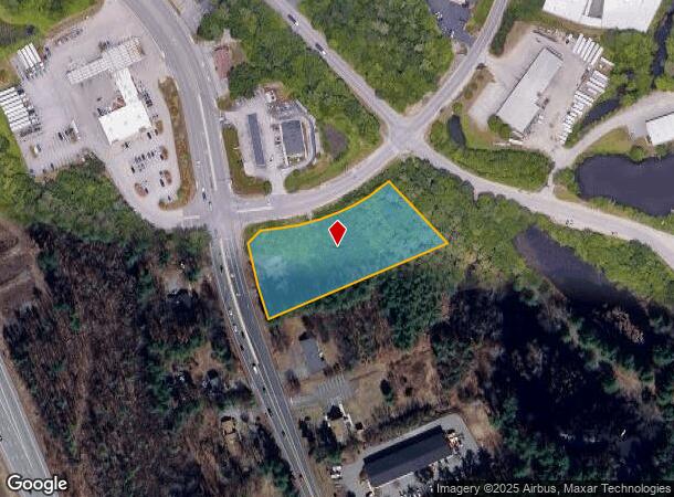
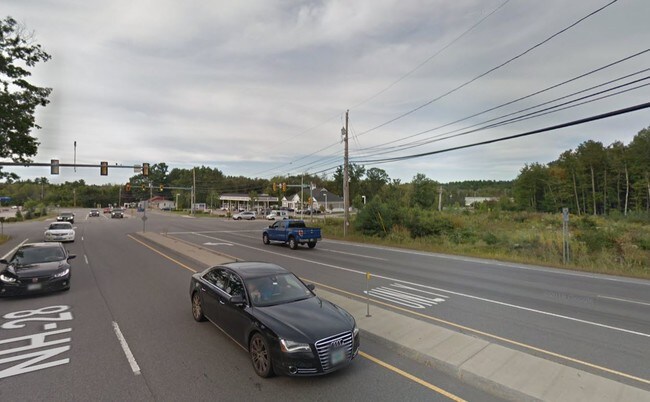
Property Record
120 Rockingham Rd, Londonderry, NH 03053

NEARBY LISTINGS FOR SALE OR LEASE
Property Detail
120 Rockingham Rd
LOND-000016-000000-000079
Rockingham
Commercialacreage
New Hampshire
X
79-0
33015C0336E
1.71 AC
2024
Rockingham
2024
Boston
003703
Boston-Cambridge-Newton, MA-NH
DEMOGRAPHICS near 120 Rockingham Rd
1 Mile
3 Mile
5 Mile
2024 Total Population
1,858
23,585
61,998
2029 Population
1,959
24,638
64,254
Pop Growth 2024-2029
+ 5.44%
+ 4.46%
+ 3.64%
Average Age
40
40
41
2024 Total Households
763
9,131
24,505
HH Growth 2024-2029
+ 5.37%
+ 4.35%
+ 3.55%
Median Household Inc
$97,321
$103,732
$96,349
Avg Household Size
2.40
2.50
2.50
2024 Avg HH Vehicles
2.00
2.00
2.00
Median Home Value
$495,485
$394,278
$358,436
Median Year Built
2003
1984
1982
Nearby Places
Map Layers
Map Styles
 Street
 Aerial
- Restaurants
- Banks
- Shops
- Fitness
- Groceries
PUBLIC TRANSPORTATION
AIRPORT
Manchester Boston Regional
DRIVE
WALK
Distance
Manchester Boston Regional
16 min
7.0 mi
Portsmouth International at Pease
DRIVE
WALK
Distance
Portsmouth International at Pease
64 min
45.2 mi
Freight Ports
Port of Boston
DRIVE
WALK
Distance
Port of Boston
72 min
47.5 mi
SALE & LEASE HISTORY
LISTING DATE
SALE/LEASE

Sep 18, 2019
For Lease
Feb 12, 2019
For Lease
Nearby Properties
Address
Land Use
TOTAL SIZE
Lot Size
Zoning
Address
Land Use
TOTAL SIZE
Lot Size
Zoning
43.88 AC
MHDR
Address
Land Use
TOTAL SIZE
Lot Size
Zoning
15.44 AC
AR-I
Address
Land Use
TOTAL SIZE
Lot Size
Zoning
8,064 SF
34.29 AC
Address
Land Use
TOTAL SIZE
Lot Size
Zoning
1,710 SF
65 AC
AR-I
Address
Land Use
TOTAL SIZE
Lot Size
Zoning
180,600 SF
14.19 AC
IND-I
Address
Land Use
TOTAL SIZE
Lot Size
Zoning
366,008 SF
41.69 AC
IND-I
Address
Land Use
TOTAL SIZE
Lot Size
Zoning
487,970 SF
79.74 AC
IND-I
Address
Land Use
TOTAL SIZE
Lot Size
Zoning
133,188 SF
1.53 AC
AR-I
Address
Land Use
TOTAL SIZE
Lot Size
Zoning
23.03 AC
GC
Address
Land Use
TOTAL SIZE
Lot Size
Zoning
166,979 SF
22.08 AC
MHDR
Address
Land Use
TOTAL SIZE
Lot Size
Zoning
119,139 SF
25.87 AC
IND-I
Address
Land Use
TOTAL SIZE
Lot Size
Zoning
244,637 SF
27.28 AC
IND-II
Address
Land Use
TOTAL SIZE
Lot Size
Zoning
117,412 SF
12.86 AC
C-II
Address
Land Use
TOTAL SIZE
Lot Size
Zoning
33.45 AC
IND4
Address
Land Use
TOTAL SIZE
Lot Size
Zoning
154,551 SF
55.80 AC
IND4
Address
Land Use
TOTAL SIZE
Lot Size
Zoning
86,168 SF
17 AC
MDR
Address
Land Use
TOTAL SIZE
Lot Size
Zoning
90,406 SF
24.78 AC
AR-I
Address
Land Use
TOTAL SIZE
Lot Size
Zoning
79,447 SF
6.83 AC
GC2
Address
Land Use
TOTAL SIZE
Lot Size
Zoning
69,266 SF
6.02 AC
MHDR
Address
Land Use
TOTAL SIZE
Lot Size
Zoning
42,956 SF
2.31 AC
Address
Land Use
TOTAL SIZE
Lot Size
Zoning
125,060 SF
8.76 AC
IND-I
Address
Land Use
TOTAL SIZE
Lot Size
Zoning
16.50 AC
C-II
Address
Land Use
TOTAL SIZE
Lot Size
Zoning
121,108 SF
14.89 AC
IND4
Address
Land Use
TOTAL SIZE
Lot Size
Zoning
722 SF
65 AC
Address
Land Use
TOTAL SIZE
Lot Size
Zoning
3.09 AC
IND4
Address
Land Use
TOTAL SIZE
Lot Size
Zoning
2.73 AC
IND4
Address
Land Use
TOTAL SIZE
Lot Size
Zoning
2.21 AC
GC
Address
Land Use
TOTAL SIZE
Lot Size
Zoning
9.18 AC
IND4
Address
Land Use
TOTAL SIZE
Lot Size
Zoning
71,810 SF
12.37 AC
Address
Land Use
TOTAL SIZE
Lot Size
Zoning
54,940 SF
3.78 AC
MHDR
The World's #1 Commercial Real Estate Marketplace
Connect with us
© 2025 CoStar Group
The information above has been obtained from sources believed reliable. While we do not doubt its accuracy we have not verified it and make no guarantee, warranty or representation about it. It is your responsibility to independently confirm its accuracy and completeness. Any projections, opinions, assumptions, or estimates used are for example only and do not represent the current or future performance of the property. The value of this transaction to you depends on tax and other factors which should be evaluated by your tax, financial, and legal advisors. You and your advisors should conduct a careful, independent investigation of the property to determine to your satisfaction the suitability of the property for your needs.