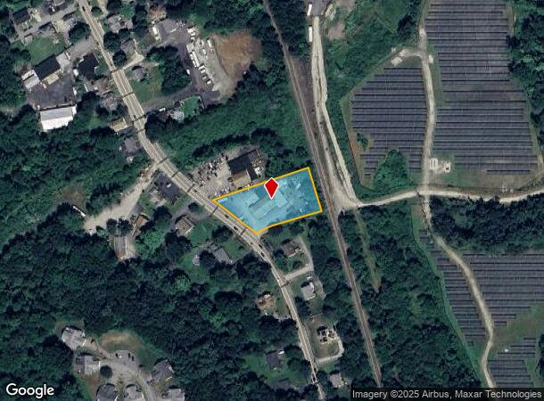
Property Record
120 S Main St, Uxbridge, MA 01569


NEARBY LISTINGS FOR SALE OR LEASE
Property Detail
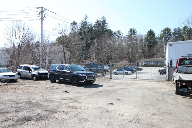
120 S Main St
Autorepair
Worcester
X
Massachusetts
25021C0300E
0.91 AC
2025
Outlying Worcester
2025
Boston
749100
Worcester, MA
8,605 SF
UXBR-000250-002685
DEMOGRAPHICS near 120 S Main St
1 mile
3 mile
5 mile
2024 Total Population
4,828
16,400
40,761
2029 Population
4,840
16,400
40,675
Pop Growth 2024-2029
+ 0.25%
0.00%
(0.21%)
Average Age
42
43
42
2024 Total Households
1,892
6,416
15,581
HH Growth 2024-2029
+ 0.11%
(0.09%)
(0.28%)
Median Household Inc
$122,188
$112,741
$112,063
Avg Household Size
2.50
2.50
2.60
2024 Avg HH Vehicles
2.00
2.00
2.00
Median Home Value
$425,381
$415,378
$416,318
Median Year Built
1980
1981
1980
Nearby Places
Map Layers
Map Styles
 Street
 Aerial
Transit
 Traffic
 Biking
Places
Listings with unknown addresses are not visible on the map
- Restaurants
- Banks
- Shops
- Fitness
- Groceries
PUBLIC TRANSPORTATION
AIRPORT
Worcester Regional
Drive
Walk
Distance
Worcester Regional
40 min
24.0 mi
Rhode Island Tf Green International
Drive
Walk
Distance
Rhode Island Tf Green International
45 min
30.4 mi
Freight Ports
Port of Davisville, RI
Drive
Walk
Distance
Port of Davisville, RI
58 min
42.3 mi
SALE & LEASE HISTORY
LISTING DATE
SALE/LEASE

Mar 22, 2022
For Sale
Jul 24, 2018
For Sale
Aug 19, 2019
For Sale
Nearby Properties
Address
Land Use
TOTAL SIZE
Lot Size
Zoning
Address
Land Use
TOTAL SIZE
Lot Size
Zoning
450,800 SF
56.41 AC
I
Address
Land Use
TOTAL SIZE
Lot Size
Zoning
158,722 SF
77.55 AC
Address
Land Use
TOTAL SIZE
Lot Size
Zoning
108.65 AC
RC
Address
Land Use
TOTAL SIZE
Lot Size
Zoning
192,817 SF
36.30 AC
RA
Address
Land Use
TOTAL SIZE
Lot Size
Zoning
48,071 SF
44.42 AC
I
Address
Land Use
TOTAL SIZE
Lot Size
Zoning
50.49 AC
Address
Land Use
TOTAL SIZE
Lot Size
Zoning
75,977 SF
12.90 AC
RB
Address
Land Use
TOTAL SIZE
Lot Size
Zoning
67,716 SF
42.39 AC
Address
Land Use
TOTAL SIZE
Lot Size
Zoning
119,200 SF
16.15 AC
I
Address
Land Use
TOTAL SIZE
Lot Size
Zoning
93,424 SF
6.90 AC
I
Address
Land Use
TOTAL SIZE
Lot Size
Zoning
28,468 SF
1.24 AC
I
Address
Land Use
TOTAL SIZE
Lot Size
Zoning
25,100 SF
7.40 AC
I
Address
Land Use
TOTAL SIZE
Lot Size
Zoning
41,071 SF
0.61 AC
RA
Address
Land Use
TOTAL SIZE
Lot Size
Zoning
25,601 SF
9.26 AC
RB
Address
Land Use
TOTAL SIZE
Lot Size
Zoning
Address
Land Use
TOTAL SIZE
Lot Size
Zoning
28,170 SF
2.02 AC
RC
Address
Land Use
TOTAL SIZE
Lot Size
Zoning
45,960 SF
2.88 AC
RA
Address
Land Use
TOTAL SIZE
Lot Size
Zoning
35,706 SF
2.87 AC
RB
Address
Land Use
TOTAL SIZE
Lot Size
Zoning
37,580 SF
14.10 AC
RB
Address
Land Use
TOTAL SIZE
Lot Size
Zoning
64,110 SF
6 AC
I
Address
Land Use
TOTAL SIZE
Lot Size
Zoning
70,000 SF
5.84 AC
I
Address
Land Use
TOTAL SIZE
Lot Size
Zoning
33,552 SF
7.87 AC
I
Address
Land Use
TOTAL SIZE
Lot Size
Zoning
53,875 SF
5.42 AC
C
Address
Land Use
TOTAL SIZE
Lot Size
Zoning
7,176 SF
4.55 AC
I
Address
Land Use
TOTAL SIZE
Lot Size
Zoning
56.47 AC
RES
Address
Land Use
TOTAL SIZE
Lot Size
Zoning
25,702 SF
7.04 AC
AG
Address
Land Use
TOTAL SIZE
Lot Size
Zoning
117,586 SF
18.85 AC
B
Address
Land Use
TOTAL SIZE
Lot Size
Zoning
22,680 SF
29.31 AC
RC
Address
Land Use
TOTAL SIZE
Lot Size
Zoning
44,302 SF
7.10 AC
RA
Address
Land Use
TOTAL SIZE
Lot Size
Zoning
17,987 SF
I
The World's #1 Commercial Real Estate Marketplace
Connect with us
© 2026 CoStar Group
The information above has been obtained from sources believed reliable. While we do not doubt its accuracy we have not verified it and make no guarantee, warranty or representation about it. It is your responsibility to independently confirm its accuracy and completeness. Any projections, opinions, assumptions, or estimates used are for example only and do not represent the current or future performance of the property. The value of this transaction to you depends on tax and other factors which should be evaluated by your tax, financial, and legal advisors. You and your advisors should conduct a careful, independent investigation of the property to determine to your satisfaction the suitability of the property for your needs.