Property Record
110 Se 19Th St, Moore, OK 73160


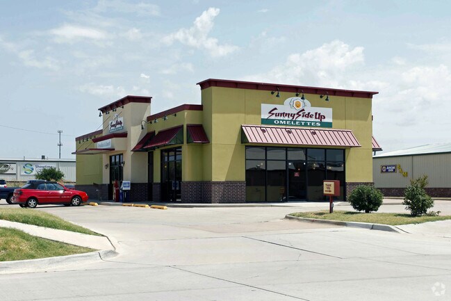
Property Detail
110 Se 19Th St
Oklahoma City, OK
CRYSTAL CROSSING PUD AMENDED LT 1 & PRT LT 3 BLK 1 AKA BEG 327.33E & S 03D E50.08 NW/C NE/4 26-10-3W S 03D E233.39 W84.41 N32.86 W200 N175 N 45D E35.42 E245.35 POB
R0191299
CLEVELAND
Restaurantbuilding
Oklahoma
B and X Area of moderate flood hazard, usually the area between the limits of the 100-year and 500-year floods.
1
2025
1.32 AC
2025
Norman
202203
Oklahoma City
NEARBY LISTINGS FOR SALE OR LEASE
DEMOGRAPHICS near 110 Se 19Th St
1 mile
3 mile
5 mile
2025 Total Population
8,492
71,652
130,162
2030 Population
8,645
72,827
132,782
Pop Growth 2025-2030
+ 1.80%
+ 1.64%
+ 2.01%
Average Age
36
38
39
2025 Total Households
3,362
27,048
49,999
HH Growth 2025-2030
+ 1.96%
+ 1.78%
+ 2.19%
Median Household Inc
$85,085
$82,132
$82,521
Avg Household Size
2.50
2.60
2.50
2025 Avg HH Vehicles
2.00
2.00
2.00
Median Home Value
$219,854
$224,996
$250,388
Median Year Built
1999
1993
1995
Nearby Places
Map Layers
Map Styles
 Street
 Aerial
Transit
 Traffic
 Biking
Places
Listings with unknown addresses are not visible on the map
- Restaurants
- Banks
- Shops
- Fitness
- Groceries
PUBLIC TRANSPORTATION
AIRPORT
Will Rogers World
Drive
Walk
Distance
Will Rogers World
24 min
13.7 mi
Nearby Properties
Address
Land Use
TOTAL SIZE
Lot Size
Zoning
Address
Land Use
TOTAL SIZE
Lot Size
Zoning
Address
Land Use
TOTAL SIZE
Lot Size
Zoning
Address
Land Use
TOTAL SIZE
Lot Size
Zoning
3,246 SF
10 AC
Address
Land Use
TOTAL SIZE
Lot Size
Zoning
44,478 SF
2.44 AC
Address
Land Use
TOTAL SIZE
Lot Size
Zoning
Address
Land Use
TOTAL SIZE
Lot Size
Zoning
31,216 SF
10 AC
Address
Land Use
TOTAL SIZE
Lot Size
Zoning
11.36 AC
C4
Address
Land Use
TOTAL SIZE
Lot Size
Zoning
10.81 AC
Address
Land Use
TOTAL SIZE
Lot Size
Zoning
554,068 SF
71.81 AC
Address
Land Use
TOTAL SIZE
Lot Size
Zoning
Address
Land Use
TOTAL SIZE
Lot Size
Zoning
2,200 SF
12.41 AC
Address
Land Use
TOTAL SIZE
Lot Size
Zoning
33,780 SF
17.24 AC
Address
Land Use
TOTAL SIZE
Lot Size
Zoning
29.38 AC
Address
Land Use
TOTAL SIZE
Lot Size
Zoning
9.50 AC
Address
Land Use
TOTAL SIZE
Lot Size
Zoning
1.85 AC
Address
Land Use
TOTAL SIZE
Lot Size
Zoning
0.77 AC
Address
Land Use
TOTAL SIZE
Lot Size
Zoning
0.89 AC
Address
Land Use
TOTAL SIZE
Lot Size
Zoning
1.86 AC
Address
Land Use
TOTAL SIZE
Lot Size
Zoning
18.41 AC
Address
Land Use
TOTAL SIZE
Lot Size
Zoning
34,400 SF
5.03 AC
Address
Land Use
TOTAL SIZE
Lot Size
Zoning
29,174 SF
16.62 AC
Address
Land Use
TOTAL SIZE
Lot Size
Zoning
25,590 SF
14.96 AC
Address
Land Use
TOTAL SIZE
Lot Size
Zoning
18,672 SF
8.53 AC
Address
Land Use
TOTAL SIZE
Lot Size
Zoning
0.64 AC
Address
Land Use
TOTAL SIZE
Lot Size
Zoning
1.40 AC
Address
Land Use
TOTAL SIZE
Lot Size
Zoning
3.54 AC
Address
Land Use
TOTAL SIZE
Lot Size
Zoning
146,155 SF
23.34 AC
Address
Land Use
TOTAL SIZE
Lot Size
Zoning
Address
Land Use
TOTAL SIZE
Lot Size
Zoning
1.34 AC
Address
Land Use
TOTAL SIZE
Lot Size
Zoning
210,816 SF
10.45 AC
The World's #1 Commercial Real Estate Marketplace
Connect with us
© 2026 CoStar Group
The information above has been obtained from sources believed reliable. While we do not doubt its accuracy we have not verified it and make no guarantee, warranty or representation about it. It is your responsibility to independently confirm its accuracy and completeness. Any projections, opinions, assumptions, or estimates used are for example only and do not represent the current or future performance of the property. The value of this transaction to you depends on tax and other factors which should be evaluated by your tax, financial, and legal advisors. You and your advisors should conduct a careful, independent investigation of the property to determine to your satisfaction the suitability of the property for your needs.