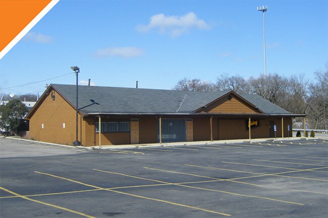
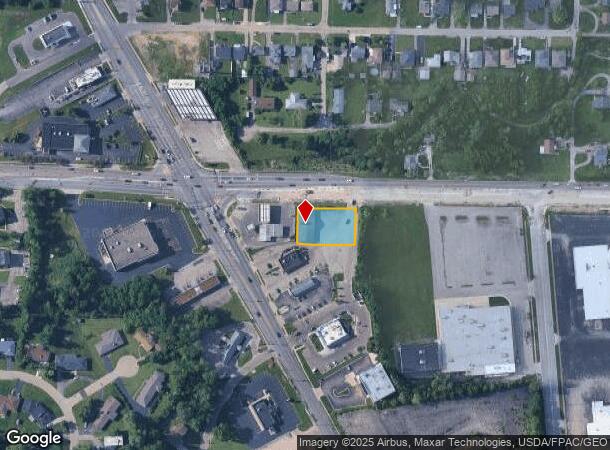
Property Record
120 Shoup Mill Rd, Dayton, OH 45415


NEARBY LISTINGS FOR SALE OR LEASE
Property Detail
120 Shoup Mill Rd
E20-01008-0213
6-2-8 213E (.0700AC)
Storebuilding
Montgomery
X
Ohio
39113C0161E
0.57 AC
2023
North Dayton
2024
Cincinnati/Dayton
080400
Dayton, OH
4,000 SF
DEMOGRAPHICS near 120 Shoup Mill Rd
1 Mile
3 Mile
5 Mile
2024 Total Population
8,197
72,040
156,968
2029 Population
8,144
72,644
158,462
Pop Growth 2024-2029
(0.65%)
+ 0.84%
+ 0.95%
Average Age
43
40
40
2024 Total Households
3,917
31,117
69,039
HH Growth 2024-2029
(0.69%)
+ 0.67%
+ 0.90%
Median Household Inc
$44,445
$41,083
$40,922
Avg Household Size
2.00
2.20
2.20
2024 Avg HH Vehicles
2.00
1.00
1.00
Median Home Value
$129,131
$90,679
$101,988
Median Year Built
1959
1956
1958
Nearby Places
Map Layers
Map Styles
 Street
 Aerial
- Restaurants
- Banks
- Shops
- Fitness
- Groceries
PUBLIC TRANSPORTATION
AIRPORT
James M Cox Dayton International
DRIVE
WALK
Distance
James M Cox Dayton International
16 min
7.9 mi
SALE & LEASE HISTORY
LISTING DATE
SALE/LEASE

Sep 25, 2016
For Lease
Sep 24, 2016
For Sale
Nearby Properties
Address
Land Use
TOTAL SIZE
Lot Size
Zoning
Address
Land Use
TOTAL SIZE
Lot Size
Zoning
923.52 AC
Address
Land Use
TOTAL SIZE
Lot Size
Zoning
22,133 SF
47.58 AC
Address
Land Use
TOTAL SIZE
Lot Size
Zoning
573,962 SF
1,128.84 AC
Address
Land Use
TOTAL SIZE
Lot Size
Zoning
5.92 AC
Address
Land Use
TOTAL SIZE
Lot Size
Zoning
144,340 SF
91.38 AC
Address
Land Use
TOTAL SIZE
Lot Size
Zoning
20.16 AC
Address
Land Use
TOTAL SIZE
Lot Size
Zoning
170,977 SF
8.65 AC
Address
Land Use
TOTAL SIZE
Lot Size
Zoning
100,716 SF
4.31 AC
Address
Land Use
TOTAL SIZE
Lot Size
Zoning
505,736 SF
45.42 AC
Address
Land Use
TOTAL SIZE
Lot Size
Zoning
313,421 SF
19.55 AC
Address
Land Use
TOTAL SIZE
Lot Size
Zoning
558,933 SF
19.55 AC
Address
Land Use
TOTAL SIZE
Lot Size
Zoning
183,333 SF
5.12 AC
Address
Land Use
TOTAL SIZE
Lot Size
Zoning
10.87 AC
Address
Land Use
TOTAL SIZE
Lot Size
Zoning
220,548 SF
23.11 AC
Address
Land Use
TOTAL SIZE
Lot Size
Zoning
509,060 SF
31.03 AC
Address
Land Use
TOTAL SIZE
Lot Size
Zoning
12,924 SF
51.33 AC
Address
Land Use
TOTAL SIZE
Lot Size
Zoning
6.25 AC
Address
Land Use
TOTAL SIZE
Lot Size
Zoning
94,671 SF
6.42 AC
Address
Land Use
TOTAL SIZE
Lot Size
Zoning
106,375 SF
2.26 AC
Address
Land Use
TOTAL SIZE
Lot Size
Zoning
23.29 AC
Address
Land Use
TOTAL SIZE
Lot Size
Zoning
6.57 AC
Address
Land Use
TOTAL SIZE
Lot Size
Zoning
101,698 SF
19 AC
Address
Land Use
TOTAL SIZE
Lot Size
Zoning
193,311 SF
9.37 AC
Address
Land Use
TOTAL SIZE
Lot Size
Zoning
243,256 SF
13.58 AC
Address
Land Use
TOTAL SIZE
Lot Size
Zoning
46,592 SF
5.32 AC
Address
Land Use
TOTAL SIZE
Lot Size
Zoning
17.54 AC
Address
Land Use
TOTAL SIZE
Lot Size
Zoning
263,022 SF
19.33 AC
Address
Land Use
TOTAL SIZE
Lot Size
Zoning
57,467 SF
5.33 AC
Address
Land Use
TOTAL SIZE
Lot Size
Zoning
68,196 SF
3.55 AC
Address
Land Use
TOTAL SIZE
Lot Size
Zoning
92,782 SF
12.44 AC
The World's #1 Commercial Real Estate Marketplace
Connect with us
© 2025 CoStar Group
The information above has been obtained from sources believed reliable. While we do not doubt its accuracy we have not verified it and make no guarantee, warranty or representation about it. It is your responsibility to independently confirm its accuracy and completeness. Any projections, opinions, assumptions, or estimates used are for example only and do not represent the current or future performance of the property. The value of this transaction to you depends on tax and other factors which should be evaluated by your tax, financial, and legal advisors. You and your advisors should conduct a careful, independent investigation of the property to determine to your satisfaction the suitability of the property for your needs.