Property Record
120 Wauregan Rd, Danielson, CT 06239

Property Detail
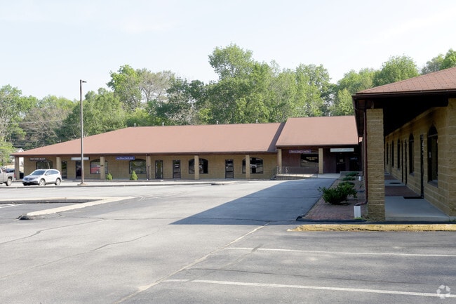
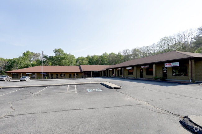
120 Wauregan Rd
Regionalshoppingcenterormallwithanchorstore
Northeastern Ct
GC
Connecticut
A Areas with a 1% annual chance of flooding and a 26% chance of flooding over the life of a 30-year mortgage.
3.88 AC
2025
Windham County
2025
Hartford
904500
Willimantic, CT
23,075 SF
KILL-000220-000000-000021
NEARBY LISTINGS FOR SALE OR LEASE
DEMOGRAPHICS near 120 Wauregan Rd
1 mile
3 mile
5 mile
2025 Total Population
3,651
14,772
29,909
2030 Population
3,752
15,205
30,694
Pop Growth 2025-2030
+ 2.77%
+ 2.93%
+ 2.62%
Average Age
41
43
43
2025 Total Households
1,573
6,079
11,958
HH Growth 2025-2030
+ 2.86%
+ 3.04%
+ 2.74%
Median Household Inc
$51,905
$82,523
$88,544
Avg Household Size
2.30
2.30
2.40
2025 Avg HH Vehicles
2.00
2.00
2.00
Median Home Value
$311,165
$278,813
$295,743
Median Year Built
1950
1964
1970
Nearby Places
Map Layers
Map Styles
 Street
 Aerial
Layers
 Traffic
 Biking
Places
Listings with unknown addresses are not visible on the map
- Restaurants
- Banks
- Shops
- Fitness
- Groceries
Nearby Properties
Address
Land Use
TOTAL SIZE
Lot Size
Zoning
Address
Land Use
TOTAL SIZE
Lot Size
Zoning
203,150 SF
21 AC
LD
Address
Land Use
TOTAL SIZE
Lot Size
Zoning
22 AC
I
Address
Land Use
TOTAL SIZE
Lot Size
Zoning
62 AC
LD
Address
Land Use
TOTAL SIZE
Lot Size
Zoning
53,306 SF
1.60 AC
BI
Address
Land Use
TOTAL SIZE
Lot Size
Zoning
54.70 AC
RA
Address
Land Use
TOTAL SIZE
Lot Size
Zoning
227 AC
LD
Address
Land Use
TOTAL SIZE
Lot Size
Zoning
147,139 SF
25.48 AC
PC
Address
Land Use
TOTAL SIZE
Lot Size
Zoning
148,118 SF
17 AC
BRHD
Address
Land Use
TOTAL SIZE
Lot Size
Zoning
59,552 SF
4.28 AC
GC
Address
Land Use
TOTAL SIZE
Lot Size
Zoning
50,707 SF
10.50 AC
BRHD
Address
Land Use
TOTAL SIZE
Lot Size
Zoning
67,994 SF
8.30 AC
GC
Address
Land Use
TOTAL SIZE
Lot Size
Zoning
15 AC
I
Address
Land Use
TOTAL SIZE
Lot Size
Zoning
9.77 AC
PC
Address
Land Use
TOTAL SIZE
Lot Size
Zoning
45,960 SF
1.40 AC
MD
Address
Land Use
TOTAL SIZE
Lot Size
Zoning
19.85 AC
R30
Address
Land Use
TOTAL SIZE
Lot Size
Zoning
12.20 AC
MD
Address
Land Use
TOTAL SIZE
Lot Size
Zoning
18,958 SF
1.52 AC
BGC
Address
Land Use
TOTAL SIZE
Lot Size
Zoning
9.12 AC
R10
Address
Land Use
TOTAL SIZE
Lot Size
Zoning
13,472 SF
1.40 AC
PC
Address
Land Use
TOTAL SIZE
Lot Size
Zoning
14,524 SF
0.92 AC
RHD
Address
Land Use
TOTAL SIZE
Lot Size
Zoning
4.60 AC
BRHD
Address
Land Use
TOTAL SIZE
Lot Size
Zoning
33,486 SF
4.10 AC
MMUDD
Address
Land Use
TOTAL SIZE
Lot Size
Zoning
28,678 SF
0.95 AC
BRHD
Address
Land Use
TOTAL SIZE
Lot Size
Zoning
4.80 AC
RHD
Address
Land Use
TOTAL SIZE
Lot Size
Zoning
Address
Land Use
TOTAL SIZE
Lot Size
Zoning
13 AC
I
Address
Land Use
TOTAL SIZE
Lot Size
Zoning
17,473 SF
3.49 AC
PC
Address
Land Use
TOTAL SIZE
Lot Size
Zoning
2.83 AC
GC
Address
Land Use
TOTAL SIZE
Lot Size
Zoning
25,942 SF
3.52 AC
R10
Address
Land Use
TOTAL SIZE
Lot Size
Zoning
7,116 SF
2.10 AC
BGC
The World's #1 Commercial Real Estate Marketplace
Connect with us
© 2026 CoStar Group
The information above has been obtained from sources believed reliable. While we do not doubt its accuracy we have not verified it and make no guarantee, warranty or representation about it. It is your responsibility to independently confirm its accuracy and completeness. Any projections, opinions, assumptions, or estimates used are for example only and do not represent the current or future performance of the property. The value of this transaction to you depends on tax and other factors which should be evaluated by your tax, financial, and legal advisors. You and your advisors should conduct a careful, independent investigation of the property to determine to your satisfaction the suitability of the property for your needs.