Property Record
120 Woodland Ave, Reno, NV 89523
NEARBY LISTINGS FOR SALE OR LEASE
-
-
View all Reno listings for lease on LoopNet.com
Property Detail
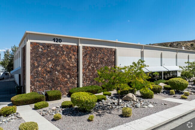
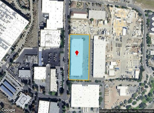
120 Woodland Ave
Reno, NV
_Unspecified
212-050-11
PM 427 LT A
Industrialgeneral
Washoe
X
Nevada
32031C3019G
a
2025
2.95 AC
2026
West Reno
002302
Reno/Sparks
61,600 SF
DEMOGRAPHICS near 120 Woodland Ave
1 Mile
3 Mile
5 Mile
2024 Total Population
3,677
49,904
111,112
2029 Population
3,855
52,859
117,045
Pop Growth 2024-2029
+ 4.84%
+ 5.92%
+ 5.34%
Average Age
42
42
42
2024 Total Households
1,720
20,732
49,434
HH Growth 2024-2029
+ 5.00%
+ 6.11%
+ 5.46%
Median Household Inc
$73,492
$91,062
$74,835
Avg Household Size
2.00
2.40
2.20
2024 Avg HH Vehicles
2.00
2.00
2.00
Median Home Value
$568,731
$543,136
$545,198
Median Year Built
2000
1995
1986
Nearby Places
- Restaurants
- Banks
- Shops
- Fitness
- Groceries
PUBLIC TRANSPORTATION
COMMUTER RAIL
DRIVE
WALK
Distance
11 min
5.2 mi
AIRPORT
Reno/Tahoe International
DRIVE
WALK
Distance
Reno/Tahoe International
33 min
12.7 mi
SALE & LEASE HISTORY
LISTING DATE
SALE/LEASE

Sep 25, 2016
For Lease
Jun 12, 2020
For Lease
Nearby Properties
Address
Land Use
TOTAL SIZE
Lot Size
Zoning
Address
Land Use
TOTAL SIZE
Lot Size
Zoning
55,187 SF
116.12 AC
GC
Address
Land Use
TOTAL SIZE
Lot Size
Zoning
477,926 SF
54.37 AC
MF14
Address
Land Use
TOTAL SIZE
Lot Size
Zoning
306,626 SF
17.61 AC
MF14 44% /
Address
Land Use
TOTAL SIZE
Lot Size
Zoning
331,462 SF
20.10 AC
PD
Address
Land Use
TOTAL SIZE
Lot Size
Zoning
304,344 SF
10.24 AC
GC
Address
Land Use
TOTAL SIZE
Lot Size
Zoning
317,507 SF
19.43 AC
MF14
Address
Land Use
TOTAL SIZE
Lot Size
Zoning
305,060 SF
23.90 AC
SPD
Address
Land Use
TOTAL SIZE
Lot Size
Zoning
272,580 SF
18.90 AC
MF21
Address
Land Use
TOTAL SIZE
Lot Size
Zoning
260,382 SF
18.77 AC
PD
Address
Land Use
TOTAL SIZE
Lot Size
Zoning
303,512 SF
20.60 AC
MF30
Address
Land Use
TOTAL SIZE
Lot Size
Zoning
293,364 SF
21.87 AC
MF14
Address
Land Use
TOTAL SIZE
Lot Size
Zoning
182,838 SF
8.02 AC
MS
Address
Land Use
TOTAL SIZE
Lot Size
Zoning
254,180 SF
15.99 AC
MF14
Address
Land Use
TOTAL SIZE
Lot Size
Zoning
259,461 SF
16.24 AC
MF30
Address
Land Use
TOTAL SIZE
Lot Size
Zoning
213,835 SF
12.53 AC
MF21
Address
Land Use
TOTAL SIZE
Lot Size
Zoning
342,672 SF
18.39 AC
MS
Address
Land Use
TOTAL SIZE
Lot Size
Zoning
92,930 SF
2.68 AC
MF21
Address
Land Use
TOTAL SIZE
Lot Size
Zoning
205,916 SF
22.44 AC
GC
Address
Land Use
TOTAL SIZE
Lot Size
Zoning
247,315 SF
20.74 AC
MF14
Address
Land Use
TOTAL SIZE
Lot Size
Zoning
77,545 SF
4.82 AC
PF
Address
Land Use
TOTAL SIZE
Lot Size
Zoning
170,791 SF
9.37 AC
MF30
Address
Land Use
TOTAL SIZE
Lot Size
Zoning
62,792 SF
3.98 AC
MF21
Address
Land Use
TOTAL SIZE
Lot Size
Zoning
116,495 SF
4.99 AC
MF30
Address
Land Use
TOTAL SIZE
Lot Size
Zoning
27.54 AC
PSP
Address
Land Use
TOTAL SIZE
Lot Size
Zoning
200,840 SF
40.35 AC
LLR1
Address
Land Use
TOTAL SIZE
Lot Size
Zoning
159,063 SF
8.39 AC
SPD
Address
Land Use
TOTAL SIZE
Lot Size
Zoning
166,421 SF
8.93 AC
GC
Address
Land Use
TOTAL SIZE
Lot Size
Zoning
125,620 SF
12.96 AC
PF
Address
Land Use
TOTAL SIZE
Lot Size
Zoning
102,040 SF
10.98 AC
PD
Address
Land Use
TOTAL SIZE
Lot Size
Zoning
62,066 SF
13.42 AC
PF
The World's #1 Commercial Real Estate Marketplace
Connect with us
© 2025 CoStar Group
The information above has been obtained from sources believed reliable. While we do not doubt its accuracy we have not verified it and make no guarantee, warranty or representation about it. It is your responsibility to independently confirm its accuracy and completeness. Any projections, opinions, assumptions, or estimates used are for example only and do not represent the current or future performance of the property. The value of this transaction to you depends on tax and other factors which should be evaluated by your tax, financial, and legal advisors. You and your advisors should conduct a careful, independent investigation of the property to determine to your satisfaction the suitability of the property for your needs.