Property Record
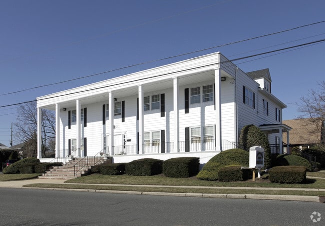
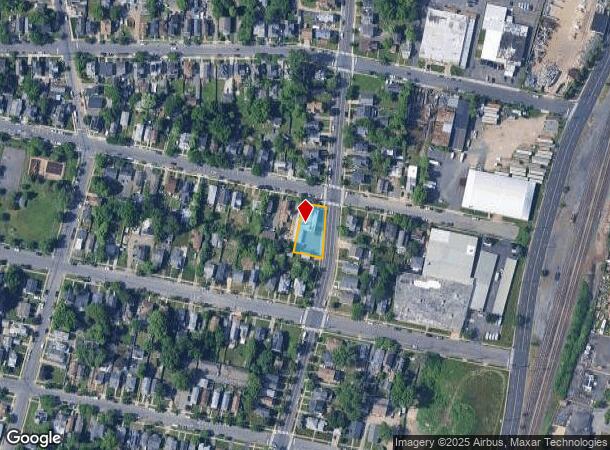
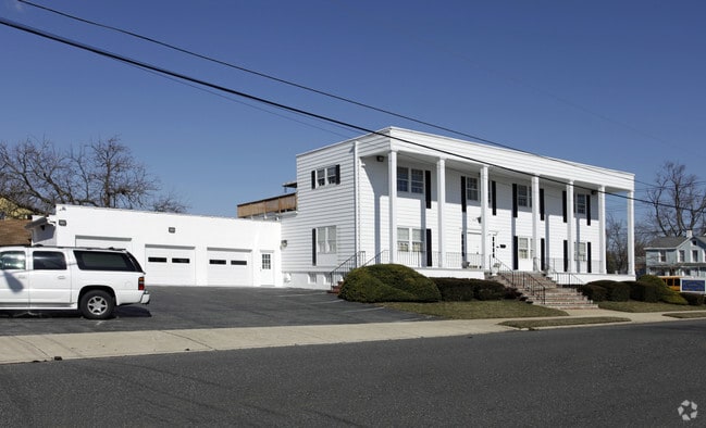
1200 10Th Ave, Neptune, NJ 07753
Property Detail
1200 10Th Ave
35-00403-0000-00014
L15
Funeralhome
Monmouth
SF05
New Jersey
B and X Area of moderate flood hazard, usually the area between the limits of the 100-year and 500-year floods.
14
2024
0.27 AC
2025
Southern Monmouth
807500
Northern New Jersey
8,189 SF
Lakewood-New Brunswick, NJ
NEARBY LISTINGS FOR SALE OR LEASE
DEMOGRAPHICS near 1200 10Th Ave
1 mile
3 mile
5 mile
2025 Total Population
26,259
80,204
138,903
2030 Population
26,867
81,947
141,606
Pop Growth 2025-2030
+ 2.32%
+ 2.17%
+ 1.95%
Average Age
42
44
44
2025 Total Households
11,559
35,308
59,505
HH Growth 2025-2030
+ 2.79%
+ 2.37%
+ 1.87%
Median Household Inc
$77,019
$98,186
$103,989
Avg Household Size
2.20
2.20
2.30
2025 Avg HH Vehicles
1.00
2.00
2.00
Median Home Value
$588,623
$644,463
$685,086
Median Year Built
1953
1960
1968
Nearby Places
Map Layers
Map Styles
 Street
 Aerial
Layers
 Traffic
 Biking
Places
Listings with unknown addresses are not visible on the map
- Restaurants
- Banks
- Shops
- Fitness
- Groceries
PUBLIC TRANSPORTATION
COMMUTER RAIL
Bradley Beach (North Jersey Coast Line - NJ Transit Commuter Rail (NJ Transit))
Drive
Walk
Distance
Bradley Beach (North Jersey Coast Line - NJ Transit Commuter Rail (NJ Transit))
1 min
8 min
0.4 mi
Asbury Park (North Jersey Coast Line - NJ Transit Commuter Rail (NJ Transit))
Drive
Walk
Distance
Asbury Park (North Jersey Coast Line - NJ Transit Commuter Rail (NJ Transit))
2 min
14 min
0.7 mi
Freight Ports
New York Container Terminal
Drive
Walk
Distance
New York Container Terminal
56 min
42.8 mi
Nearby Properties
Address
Land Use
TOTAL SIZE
Lot Size
Zoning
Address
Land Use
TOTAL SIZE
Lot Size
Zoning
26,282 SF
4.59 AC
MU0
Address
Land Use
TOTAL SIZE
Lot Size
Zoning
5,776 SF
25.50 AC
PB
Address
Land Use
TOTAL SIZE
Lot Size
Zoning
739,651 SF
27.89 AC
C
Address
Land Use
TOTAL SIZE
Lot Size
Zoning
113.60 AC
WBA
Address
Land Use
TOTAL SIZE
Lot Size
Zoning
14,632 SF
111.60 AC
C50
Address
Land Use
TOTAL SIZE
Lot Size
Zoning
1,846 SF
23.23 AC
SF10
Address
Land Use
TOTAL SIZE
Lot Size
Zoning
320,341 SF
57.85 AC
C
Address
Land Use
TOTAL SIZE
Lot Size
Zoning
32.19 AC
MF08
Address
Land Use
TOTAL SIZE
Lot Size
Zoning
271,456 SF
1.61 AC
SF05
Address
Land Use
TOTAL SIZE
Lot Size
Zoning
279,420 SF
2.01 AC
MU24
Address
Land Use
TOTAL SIZE
Lot Size
Zoning
168,732 SF
2.35 AC
MU24
Address
Land Use
TOTAL SIZE
Lot Size
Zoning
108,641 SF
10.64 AC
C-6
Address
Land Use
TOTAL SIZE
Lot Size
Zoning
1,288 SF
25.49 AC
HD-R
Address
Land Use
TOTAL SIZE
Lot Size
Zoning
5,228 SF
0.02 AC
C-3
Address
Land Use
TOTAL SIZE
Lot Size
Zoning
3,094 SF
277.60 AC
MU0
Address
Land Use
TOTAL SIZE
Lot Size
Zoning
224,683 SF
21.56 AC
CHS
Address
Land Use
TOTAL SIZE
Lot Size
Zoning
91,173 SF
4.07 AC
R3
Address
Land Use
TOTAL SIZE
Lot Size
Zoning
254,714 SF
3.40 AC
WPRA
Address
Land Use
TOTAL SIZE
Lot Size
Zoning
Address
Land Use
TOTAL SIZE
Lot Size
Zoning
1,487 SF
7.50 AC
R-B
Address
Land Use
TOTAL SIZE
Lot Size
Zoning
133,831 SF
18.38 AC
C50
Address
Land Use
TOTAL SIZE
Lot Size
Zoning
106,096 SF
0.88 AC
C0
Address
Land Use
TOTAL SIZE
Lot Size
Zoning
8.82 AC
R2
Address
Land Use
TOTAL SIZE
Lot Size
Zoning
18,556 SF
163.40 AC
SF40
Address
Land Use
TOTAL SIZE
Lot Size
Zoning
Address
Land Use
TOTAL SIZE
Lot Size
Zoning
27,328 SF
6.79 AC
HB12
Address
Land Use
TOTAL SIZE
Lot Size
Zoning
0.76 AC
R-1
Address
Land Use
TOTAL SIZE
Lot Size
Zoning
7.39 AC
R2
Address
Land Use
TOTAL SIZE
Lot Size
Zoning
8.76 AC
R1
Address
Land Use
TOTAL SIZE
Lot Size
Zoning
86,328 SF
5.96 AC
OB0
The World's #1 Commercial Real Estate Marketplace
Connect with us
© 2026 CoStar Group
The information above has been obtained from sources believed reliable. While we do not doubt its accuracy we have not verified it and make no guarantee, warranty or representation about it. It is your responsibility to independently confirm its accuracy and completeness. Any projections, opinions, assumptions, or estimates used are for example only and do not represent the current or future performance of the property. The value of this transaction to you depends on tax and other factors which should be evaluated by your tax, financial, and legal advisors. You and your advisors should conduct a careful, independent investigation of the property to determine to your satisfaction the suitability of the property for your needs.